
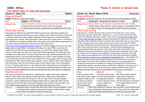
Sketch maps of the local area and plans of homes and other places will help their link school friends understand the children’s daily lives as described in their diaries. Look at OS maps and street plans. Children use symbols and a key to clarify their maps and plans.
Suitable for years 5 and 6.
Suitable for years 5 and 6.
Something went wrong, please try again later.
Thanks I like the street map link. The OS maptivity site has changed though.
Good ideas for a local studies lesson. Great link to the Ordnance Survery website which also has lots of resources.
A good practical lesson with children using their map skills to find out about their local area.
Report this resourceto let us know if it violates our terms and conditions.
Our customer service team will review your report and will be in touch.
£0.00