 Quick ViewQuick View
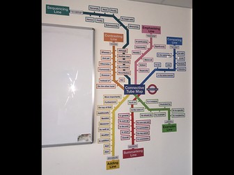 Quick View
Conjunctions Tube Map Display
Everything you need to create a display to remind students to use conjunctions in their writing. Designed in the style of a London Underground or tube map, each line of the map represents a different conjunction group with the stations represented by the conjunctions themselves, all colour coded. Note that the title in the middle will say ‘Conjunction Tube Map’ (not ‘Connective’). Simply print, laminate, cut and put up your display. It can be organised in whatever way you choose, but an image is supplied as a guide or suggestion. Hope you find it useful!
 Quick View
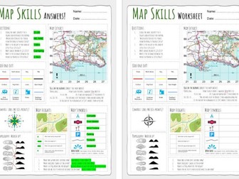
Map Skills Worksheet 1
Up to date worksheet for map skills for any Geography curriculum and Key Stage.
Includes:
4fig grid references
6fig grid references
direction
compass
scale
map symbols
and more
 Quick View
Reception Long Term Curriculum Map
This is our Reception Long Term Planning - important dates for each half term are identified (which help shape our planning), each area of learning is identified on the planning and what we cover in each half term; this also includes additional information on how children are assessed throughout the year and how the curriculum is implemented. Fully editable - microsoft word document.
World Map with Coordinates
A simple coloured world map with coordinates. Children can use the map to become familiar with countries, continents, oceans and seas! Also using their coordinates skills. Can be printed A4/A3 depending on use.
undefined
The Very Hungry Caterpillar Story Map
The Very Hungry Caterpillar Story Map- Simple pictures taken from the book to help sequencing of the story when writing.
 Quick View
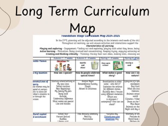
EYFS Reception Long Term Curriculum Map Plan
This comprehensive Reception Curriculum Map provides a clear overview of teaching and learning across the entire academic year, covering all areas of the EYFS.
It outlines half-termly themes, key questions and lines of enquiry, alongside carefully planned learning opportunities across every subject area, including Literacy, Maths, Understanding the World, Expressive Arts and Design, and more. The map also highlights progression in skills, ensuring a well-sequenced and purposeful curriculum that supports children from their starting points through to end-of-year expectations.
Cultural capital and enrichment opportunities are thoughtfully woven throughout, including celebrations, trips, visitors and real-life experiences that broaden children’s understanding of the world. Curriculum enhancements such as themed days, role play opportunities and high-quality texts further enrich learning and deepen engagement.
The document also embeds the Characteristics of Effective Learning, ensuring children are supported to play, explore, think critically and develop independence across all areas of provision. It is designed to be flexible, allowing adaptations based on children’s interests while maintaining clear curriculum intent.
Perfect for Reception practitioners, this resource supports long-term planning, ensures curriculum coverage, and helps create a rich, engaging and well-balanced EYFS provision.
© 2026 EYFS with Mrs S. All rights reserved.
 Quick View
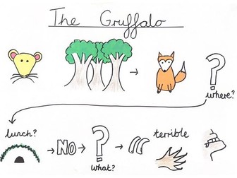
The Gruffalo Story Map
Hand drawn full story map of the Gruffalo story to help with sequencing and retelling.
Can be used for Talk for Writing approach, or to help with sequencing of the story.
 Quick View
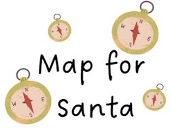
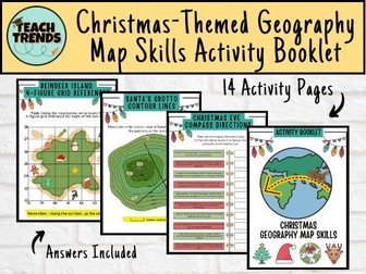
Christmas-Themed Geography Map Skills Activity Booklet
Are you ready to turn this holiday season into a global adventure for your young explorers? Introducing our enchanting Christmas-themed geography map skills activity booklet, specially crafted for curious minds aged 10-14!
Festive Learning Fun: Transform geography lessons into a holiday celebration! Each activity is designed to weave Christmas magic into essential map skills, making learning both educational and joyous.
Engaging and Age-Appropriate: Tailored for 9-12 year olds, our activities strike the perfect balance between challenge and entertainment. Watch as your child hones their map-reading skills while embracing the holiday spirit.
Santa’s Global Adventure: Follow Santa’s journey around the world! From the North Pole to bustling cities and exotic landmarks, each activity unveils a new destination, fostering cultural awareness and geographical knowledge.
Map Skills Included:
Grid References
Scale & Distance
Compass Directions
Contour Lines
Time Zones
A total of 14 activity pages with answers included.
 Quick View
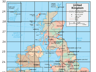
UK Grid Reference Map
Differentiated maps of the UK with grid references - children are to identify locations in each grid reference
 Quick View
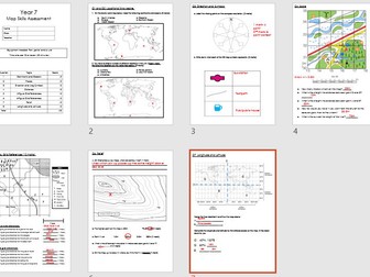 Quick View
Map Skills End of Topic Assessment
An end of unit test for year 7.
Includes all major map skills such as compass points, grid references, scale, longitude/latitude and relief. Also includes mark scheme, self reflection sheet and differentiated. DIRT tasks require foundations textbook or could be adapted to suit.
 Quick View
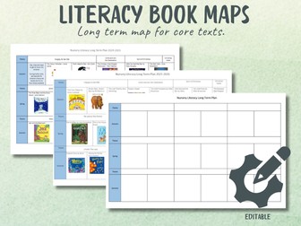
Literacy Long Term Book Maps
Map out your core texts with clarity and intention.
This editable Literacy Long Term Plan template helps you map your core books across the academic year.
Designed for Nursery and EYFS, it lets you sequence your focus texts term by term, link them to your themes (if you use them), and build a language-rich curriculum that values depth, repetition and ambitious vocabulary.
What’s included:
An editable long term literacy map template
Clear term-by-term layout (Autumn, Spring, Summer)
Space to organise core texts and themes
My completed plans from the last two academic years (2024–2025 and 2025–2026) for real-life examples and inspiration.
These are the actual documents I use to organise our core story approach - mapped carefully, reviewed regularly and adapted when the children need something different.
Perfect for:
EYFS teachers refining their literacy spine
Settings developing a strong core book approach
Subject leaders reviewing curriculum intent
Anyone who wants clarity without rewriting everything from scratch
Use it as it is, tweak it, or completely reshape it to match your curriculum. It’s fully editable.
 Quick View
 Quick View
Nursery Long Term Curriculum Map
This is our Nursery Long Term Planning - important days in each half term are identified (which help shape our planning), each area of learning is identified on the planning and what we cover in each half term; this also includes additional information on how children are assessed throughout the year and how the curriculum is implemented. Fully editable - microsoft word document.
Bundle
 Quick View
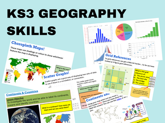
KS3 Map Skills
Full unit of work for map and graph skills. All lessons are fully resourced. Lessons are designed to last for 50-60 minutes. Lessons are resourced with videos, extension questioning, deep thinking and uses graphs/images to aid learning.
These lessons follow the Oxford KS3 curriculum and look at;
Continents & Countries
Map Skills
Directions
Distance & Scale
Grid References
Longitude & Latitude
Height
OS Symbols
Graph Skills
Each lesson includes a starter, lesson objective, plenary and various student led activities.
If you liked this resource please check out my other resources at https://www.tes.com/teaching-resources/shop/SimpleGeography
 Quick View
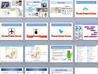
Introduction to OS map skills and map symbols
Lesson covers what maps are used for and how to read map symbols
Map Skills - Map Symbols
This map skills lesson is about map symbols. It is suitable for key stage 2 and 3 and takes 50 mins to 1 hour. The lesson includes some creative writing where students substitute words for map symbols. Within the presentation are all the printable material to support this lesson
It contains:
Three Three levels of differentiation
Starter and plenary
Printable material
Engaging game activity
Printable resource
 Quick View
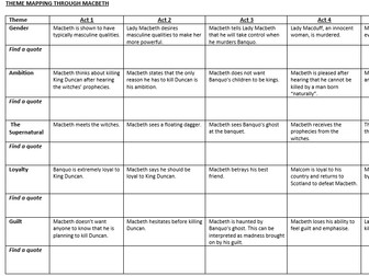
Macbeth Theme Mapping Sheet
A worksheet for students to use when studying themes in Macbeth. They must find a quote representing each theme for every act of the play.
Asdan Bronze Curriculum Mapping
This is an Asdan mapping spreadsheet for the Asdan Bronze Award challenges.
It maps the challenges into programmes of study for PSHE and assessment focuses for English (Reading, Writing, S&L), Maths and ICT.
It is not complete, as I have only done it for the challenges/modules that I am currently delivering, but it can be added to!