

Tour The Acropolis of Athens, Greece with Google Earth Tours
Make a virtual field trip to one of the world’s most ancient landmarks; the Acropolis. You will be using Google Earth to watch a pre-recorded tour of the four famous structures that sit atop the Acropolis. Learn all about the Parthenon, the Temple of Athena Nike, the Erechtheum and the Propylaea.
You will also visit four other edifices that have neighbored the Acropolis for millennia: the Theatre of Dionysus, the Odeon Herodes Atticus, the Temple of Olympian Zeus, and the Temple of Hephaestus.
The product includes a document of about 55 talking points and interesting facts about the ancient Greek site and it’s buildings.
The tour is also accompanied by a PDF file that describes what you are seeing based on the corresponding minutes in the video. This is so you can pause the tour at the given time stamp and let the class know what they are looking at.
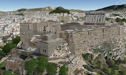
For example the document says at, “3:28 – 3:41 – The camera looks due West.
The old museum is in the foreground. If you look to the right of the museum a little bit you can make out a flag rising up from the edge of the Acropolis.
It is said that when the Nazis took over Athens during WWII, they ordered a Greek soldier who was guarding the flag to take it down. He took it down, wrapped himself in the flag, and jumped over the side of the precipice to his death in a personal protest.”
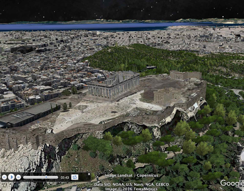
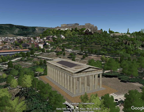
The tour begins with a view of Europe from outer space. You are then zoomed in to the site’s locations to see it from a variety of different viewpoints. The angles are chosen so the students can get a good idea of the four structures’ locations, as well as, their physical relationships to each other in their setting. Finally, you are taken back out to a long shot of Europe.
* Your computer must have Google Earth to watch these tours.
Feel free to visit some other famous landmarks in North America.
1. The Golden Gate Bridge (3:29)
2. Chichen Itza (5:38)
3. Niagara Falls (2:10)
4. Panama Canal (3:02)
5. Statue of Liberty (2:07)
6. Gateway Arch in St. Louis, Missouri (1:06)
Here are some European landmarks.
1. Stonehenge (3:29)
2. The Acropolis (5:38)
3. The Colosseum
4. The Leaning Tower of Pisa
5. The Eiffel Tower (3:15)
Tour some African sites.
1. The Egyptian Pyramids and the Great Sphinx of Giza (3:15)
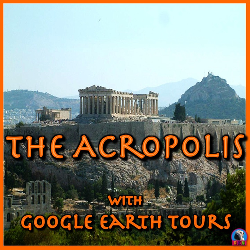
The cover photo is by Salonica84 and has a Creative Commons license. The photo can be found @ https://commons.wikimedia.org/wiki/File:Acropolis-Athens34.jpg
Google Earth Tour Map Attribution
Map Data: Google, Image Landsat / Copernicus
Data SIO, NOAA, U.S. Navy, NGA, GEBCO
Image IBCAO
Image U.S. Geological Survey
Image © 2016 TerraMetrics
Image © 2016 DigitalGlobe
Make a virtual field trip to one of the world’s most ancient landmarks; the Acropolis. You will be using Google Earth to watch a pre-recorded tour of the four famous structures that sit atop the Acropolis. Learn all about the Parthenon, the Temple of Athena Nike, the Erechtheum and the Propylaea.
You will also visit four other edifices that have neighbored the Acropolis for millennia: the Theatre of Dionysus, the Odeon Herodes Atticus, the Temple of Olympian Zeus, and the Temple of Hephaestus.
The product includes a document of about 55 talking points and interesting facts about the ancient Greek site and it’s buildings.
The tour is also accompanied by a PDF file that describes what you are seeing based on the corresponding minutes in the video. This is so you can pause the tour at the given time stamp and let the class know what they are looking at.
For example the document says at, “3:28 – 3:41 – The camera looks due West.
The old museum is in the foreground. If you look to the right of the museum a little bit you can make out a flag rising up from the edge of the Acropolis.
It is said that when the Nazis took over Athens during WWII, they ordered a Greek soldier who was guarding the flag to take it down. He took it down, wrapped himself in the flag, and jumped over the side of the precipice to his death in a personal protest.”
The tour begins with a view of Europe from outer space. You are then zoomed in to the site’s locations to see it from a variety of different viewpoints. The angles are chosen so the students can get a good idea of the four structures’ locations, as well as, their physical relationships to each other in their setting. Finally, you are taken back out to a long shot of Europe.
* Your computer must have Google Earth to watch these tours.
Feel free to visit some other famous landmarks in North America.
1. The Golden Gate Bridge (3:29)
2. Chichen Itza (5:38)
3. Niagara Falls (2:10)
4. Panama Canal (3:02)
5. Statue of Liberty (2:07)
6. Gateway Arch in St. Louis, Missouri (1:06)
Here are some European landmarks.
1. Stonehenge (3:29)
2. The Acropolis (5:38)
3. The Colosseum
4. The Leaning Tower of Pisa
5. The Eiffel Tower (3:15)
Tour some African sites.
1. The Egyptian Pyramids and the Great Sphinx of Giza (3:15)
The cover photo is by Salonica84 and has a Creative Commons license. The photo can be found @ https://commons.wikimedia.org/wiki/File:Acropolis-Athens34.jpg
Google Earth Tour Map Attribution
Map Data: Google, Image Landsat / Copernicus
Data SIO, NOAA, U.S. Navy, NGA, GEBCO
Image IBCAO
Image U.S. Geological Survey
Image © 2016 TerraMetrics
Image © 2016 DigitalGlobe
Something went wrong, please try again later.
This resource hasn't been reviewed yet
To ensure quality for our reviews, only customers who have purchased this resource can review it
Report this resourceto let us know if it violates our terms and conditions.
Our customer service team will review your report and will be in touch.
$3.99