Hello.
My methodology for lesson planning consists of three key concepts;
Simplicity for the teacher - I aim to plan lessons that are paper-resource light.
Clarity of understanding for the student - I aim to plan lessons that are clear in their sequencing.
Professional appearance - I aim to plan lessons that are designed for students rather than the board room.
I teach my lessons successfully and with enjoyment, but not every teacher is the same. I always appreciate constructive feedback :-)
LESSON COVERS:
why Rio was able to host the world cup and the economic opportunities available to it as a result. includes positives and negatives.
LESSON INVOLVES:
Main task involves students using a tourist map of Rio, and their grid referencing skills to locate and find features of the city that can give rise to economic development (depending on quality of printer - you may need to work through and point some out on the board). They then use an info sheet to annotate those places with detail and facts. They first look at the positives, then a video and a further back up info sheet helps them understand the negatives. The lesson ends with an exam question. (There is also an opportunity to review grid referencing skills before the main task)
RESOURCES:
A3 map sheet with grid referencing table. HA (higher ability) and MA (middle ability) info sheets, with negatives sheet.
NOTES;
the link to the video is embedded, just put in slide show mode and click on the video image. The keys represent key words. It is sometimes easier to put the big map up on the screen, it depends on the quality of your print out as to whether or not they can locate the places.
LESSON COVERS:
strategies used in London to overcome congestion, including: the London Underground, the Emirates skyline, the buses and the Santander hire bikes.
LESSON INVOLVES:
starts with exploring some facts about congestion identifying the trend that congestion is increasing. A video highlighting congestion issues in London is a precursor to a task where student look at different congestion strategies, rating them on a diamond graph with 4 axis, explaining how they've rated them, and looking for a pattern that shows the most effective strategy. Lesson ends with an exam question.
RESOURCES:
The diamond graph can be drawn from scratch by higher ability students, but there is a ready made copy if support is required. The video is accessed by putting the powerpoint in slide show mode and clicking on the screen grab. The strategy sheets can be printed (double sided) on different colour paper to enable them to be more identified, equally they can be put up on the board for students to work through altogether. Text on the strategy cards is differentiated.
NOTES:
Blank boxes on slides 4 and 7 are for the teacher to type in ideas as students are contributing them.
Please review with any feedback :-)
THIS IS NOW FOR THE OLD AQA A SPEC (some parts can be used depending on areas of study chosen in new spec - file can also be modernised/updated)
Colourful, memorable slides with attached questions to help geography students remember key case study information.
USES: I use them as starter memory-style quizes at the start of revision lessons, as a one-slide way to re-teach a case study and have uploaded them as a revision resource for the students.
They are all hyperlinked, so it can be used like a website when in slideshow mode. Completely editable so you can change the questions, facts, etc as best suits what you have taught.
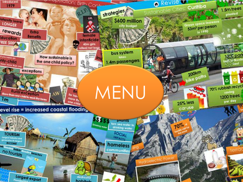
INCLUDED CASE STUDIES: Restless Earth: The Alps, Montserrat, Yellowstone super volcano,Indian Ocean Tsunami, Haiti, Kobe. Coasts: The Maldives, Holderness (erosion and management), Studland. Population: China, Kerala, UK. Tourism: Lake District, Jamaica, Antarctica. Urban: Curitiba, Cabot Circus Bristol, Favela Barrio. Rivers: Somerset Level, Bangladesh, Rutland Water.
ALSO AVAILABLE AS PART OF A BUMPER REVISION PACK HERE https://www.tes.com/teaching-resource/bumper-exam-question-pack-revision-extras-aqa-a-gcse-geography-11470618
Please leave a review and feel free to include any feedback for improvements :-)
LESSON COVERS:
Exploring what a super volcano is, how they are formed and how they are different to other volcanoes, and the potential extent of the effects of a super eruption (local vs. global)
LESSON INVOLVES:
Exploring the definition of a super volcano, using a video to introduce the concept and look at how they are formed. Developing map skills and data skills through comparing eruption size to regular eruptions. This task has a support graph for students to use. Using a video to introduce the idea of local and global effects, using notes taken from these videos to add information to maps of the world or North America - depending on ability.
RESOURCES:
Support graph template is available to complete or simply use as a guide for students to create their own. The two types of maps are in the same file on different slides - print as required.
NOTES:
The link the video is embedded, put the slides into slide show mode and then click on the video screen grab.
Please review with any feedback or if you spot any weevils in the lesson :-)
LESSON COVERS:
A range of impacts of climate change, including: increased drought, extreme weather events, spread of disease, sea level rise, extinction, etc. As well as how these impact each other.
LESSON INVOLVES:
A starts with a range of images of impacts, asking students to think about how they are connected. The main activity is a round the room information hunt with different posters on different impacts (the text on these is differentiated) students then create a visual representation in their books of how these effect human, plants and animals, and in turn how the impacts are interconnected. Last task is an exam question.
RESOURCES:
The posters are differentiated with simpler text and more complex text (the key is on the slides). These can also be simply displayed on the screen or given out as information packs. There are also a selection of graphs for more able students to use to add specifics to their impact descriptions.
NOTES:
The images on the first slide are on a timer. Click to make the first image appear, the rest will then appear in turn automatically after 15 seconds or so.
Please review with any feedback :-)
LESSON COVERS
Improvements to the UK transport infrastructure including: HS2, motorway upgrades, Heathrow third runway, Liverpool port improvements. Going on to look the challenges this presents for sustainability and Torr Quarry as an example of sustainable economic development.
LESSON INVOLVES
Watching a series of videos and making differentiated targeted notes on the different improvements in transport identified above. Then an exam question to identify that the increase in economic development leads to increased emissions. After this students then create a differentiated mini infographic on Torr Quarry as an example or where development can be sustainable - taking into account social, environmental and economic impacts. Final task is an exam question. Peer assessment mini plenaries, starter and final plenary are also included.
LESSON RESOURCES
There are sheets for students to make their video notes on, as well as template for the mini infographic.
IMPORTANT - for the infographic task the lesson uses the Blue Oxford GCSE Geography AQA text book (edited by S. Ross). If you don’t use this text book the infogRaphic task can be adapted for whichever case study you choose to use.
The lesson also includes a 5 minute “Review Previous Learning” task, as a revision tool - feel free to omit or adapt.
Please review with any feedback or if you spot any weevils in the lesson :-)
LESSON COVERS:
the definition of and difference between adaptation and mitigation and examples of how each in being employed in relation to climate change.
LESSON INVOLVES:
the main part of the lesson involves watching a selection of short videos or sections of hyperlinked videos. students make notes on a choice of two template sheets and categorise the video as an example of mitigation, adaptation, or both. Following this they choose a role from the COP21 meetings in Paris and write a speech using what they have learnt within the context of their role (prompts for what to include are on the screen).
RESOURCES:
all the videos are hyperlinked, to access them put the powerpoint in slide show mode and click on the screen grabs. Some videos have a note underneath saying which parts of the video to watch (if they are too long). Pre-teach the term "desalinisation" before showing the desalinisation video. The sheets the students can use to make notes are differentiated - the blank venn diagram is for more able students.
Please review with any feedback :-)
LESSON COVERS:
The environmental impacts of development (rapid urbanisation, deforestation, oil extraction) juxtaposed against the improvements in quality of life.
LESSON INVOLVES:
Students start off by matching images to facts and then to explanations of the environmental issue identified above. They then annotate these images with what they have learned. They then add sketches/doodles to a sketch of a Nigerian person to outline their improvements in quality of life. The final task is to create a proportional symbols map to demonstrate the impacts vs. improvement, leading the students to make a judgement over whether the development is actually worth it.
RESOURCES:
There is the picture to cut out and annotate, as well as the template of a person to trace (or print and cut out). There is also a map of Nigeria for their proportional symbols task, and the proportional symbols to either cut out or trace.
IMPORTANT: For one of the tasks the challenge extension and additional (but not crucial) support material refers to the Oxford GCSE Geography text book (blue cover) if you don’t use this these elements can be deleted or changed.
The lesson also includes a 5 minute “Review Previous Learning” task, as a revision tool - feel free to omit or adapt.
Please review with any feedback or if you spot any weevils in the lesson :-)
Here are differentiated key word sheets for the below AQA units. Each word has a space for students to write definitions.
AQA UNITS COVERED: (sheets are fully editable if you teach different units)
PAPER 1: Natural Hazards – Living World – UK Physical Landscapes
PAPER 2: Urban Issues and challenges – Economic World – Resource Management
RESOURCE CODE: HA = HIGHER ABILITY, MA = MIDDLE ABILITY
LESSON COVERS:
the location of the dam, how a dam works, the advantages and disadvantages of the dam and how it may impacts people and the environment.
LESSON INVOLVES:
students first generate questions for themselves about the dam which they then come back to answer later. The dam is then located by slowly zooming in on google earth (students to identify when they can see it). There is a video to make notes from on how a dam works, then a video for students to collect advantages and disadvantages (each video is hyperlinked if you click on the screen grab once in slide show mode). Students then read people profiles and plot each person on a graph to show how they are effected by the dam (differentiated). The final task is to write a letter as the president to the dam designer arguing for or against the dam's construction in the first place.
RESOURCES
There is an extra information sheet for any students wanting ore information.
Please review with any feedback :-)
LESSON COVERS
the major changes in the UKs economy including deindustrialisation, the post industrial economy and the move towards service industries, science and business parks.
LESSON INVOLES
the majority of the lesson is taken up by the creation of a timeline (differentiated by target)- first looking at what happened and when, then using different colours to explain why the things happened/are happening or will happen. The final task is to put these pieces together into a short story supported by mixed up sentences.
LESSON RESOURCES
the timeline activity is supported by some information sheets that are intrinsically differentiated (some info boxes are easier to read, some more complex).
The lesson also includes a 5 minute "Review Previous Learning" task, as a revision tool - feel free to omit or adapt.
Please review with any feedback or if you spot any weevils in the lesson :-)
LESSON COVERS
The evidence of and strategies for addressing the social and economic North South Divide.
LESSON INVOLVES
Starter involves adding economic data to a UK map. The primary teaching task requires students to note down key terms and numbers and then to watch a video do discover what those key terms mean in the context of a North South divide. The main task provides the students with timed slides (7 minutes each) with information about three strategies to address the North South divide: HS2, Enterprise Zones and LEPs (local enterprise partnerships) and are asked the record the information of the slides in specific ways according to target grade. Students then colour code the strategies to link it to the information learned earlier in the video, evaluating the strategies, matching them to specific issues. The final plenary uses a video. It has a bad word in it – my students can handle that but feel free to omit if wish!
LESSON RESOURCES
Videos are hyperlinked to the video screen shots. Simply put into slide show mode and then click on them.
The lesson also includes a 5 minute “Review Previous Learning” task, as a revision tool - feel free to omit or adapt.
Please review with any feedback or if you spot any weevils in the lesson :-)
LESSON COVERS
What longitude and latitude is and how it can be used to locate countries. The different characteristics of countries including biomes, temperature and other features.
LESSON SUMMARY
Lesson starts with a “quick maths” task where students are asked to come up with various numbers (no.of reindeer, continents etc) and add/subtract them to come up with an answer (closest wins as they rarely get it right, but have fun trying).
First main task introduces Longitude and Latitude using a very catchy video, and then gives students a chance to locate countries using these coordinates. The second main task asks students to use their list of countries to plot Santa’s trip and describe the places he visits using information maps (biomes, temperature and other features, as well as your own atlas if you wish).
The lesson is Christmassy themed throughout, with extension and differentiation, and there is a grid reference support task for those who are struggling with longitude and latitude.
LESSON RESOURCES
For the video click on the word “video when it is in slide show mode”. Students need to use the map template in conjunction with an atlas to work out which countries they land on (if you don’t have atlases you can print world maps from the internet). The information maps can be put up on the board if you’d rather not print in colour, equally you could ignore them altogether and use your own biome maps, or other information from your own atlases.
LESSON COVERS
How goats can be bought through Oxfam, Goat Aid operating countries, benefits of goats for reducing the development gap, as well as possible negatives.
LESSON SUMMARY
Students are initially presented with an image of a goat and asked for ideas on the advantages of goat ownership. This is followed by a 3 mark map-based exam question. Main concept is presented through 3 short videos. Students are then required to shade advantages and disadvantages of the scheme on a sheet with a challenge task for more able students to write the advantages and disadvantages from the sheet as paragraphs. Following this students then create a visual representation of the positive impacts, and knock-on positive impacts of goat ownership, with higher ability students asked to analyse the value of these benefits. Finally there is a 6 mark exam question.
LESSON RESOURCES
The videos are all hyperlinked into the word “video” which can be clicked on in slideshow mode. The “goat benefits tree” example document can be edited or used for scaffolding/for lower ability students. If you’d rather not print the shading sheet students can copy comments down into a table instead.
LESSON COVERS:
discovering what sinkholes are, why they happen and the dangers they pose for humans
LESSON INVOLVES:
students form questions about a sinkhole photo to start the lesson - they then come back and answer these questions at the end. A video introduces the concept and then definition and key words are explored. A map is used to explore and describe where they occur. Another video then explains how they occur, students then explain in their own terms through annotated diagrams. To end there is a writing exercise where students imagine they are the brother of a man swallowed by a sink hole.
SKILLS:
-Map skills with direction and continent and country location.
-Diagram drawing and annotations
RESOURCES:
the lesson includes link to videos. If you put the lesson in slide show mode and click on the screen grab of the video it will take you to the video itself. Or you can click on the image and go to insert>hyperlink across the top and copy and paste the link out of the box.
NOTES:
most activities are differentiated and/or have challenge and support options
Please review with any feedback/improvements required :-)
LESSON COVERS
How the Fairtrade process works, the positive impacts for producers, and an overview of product pricing.
LESSON INVOLVES
Starter asks students to think about and list where they may have seen the Fairtrade logo. The concept of Fairtrade is then introduced (key indicates key word). Main task uses an infographic of how Fairtrade profits and premium are spent to improve quality of life. Students either answer questions (target 4-5) or create flow charts (target 6+) to indicate how Fairtrade can reduce the development gap. The challenge version of this task gives students the option to create a flow chart with option boxes. Following this students evaluate product price comparisons – Fairtrade vs. other products. The lesson ends with an exam question with an example answer that is fully editable to suit the techniques you teach.
LESSON RESOURCES
Videos are hyperlinked to the word “video” on the slide. Put into slide show mode and then click on them.
Please review with any feedback or if you spot any weevils in the lesson :-)
LESSON COVERS:
historic and current causes of climate change, both natural and human
LESSON INVOLVES:
starts with a graph task identifying trends in climate, bulk of lesson involves students using a differentiated Fact Pack containing visual and written information on human and natural causes of climate change. At the end of the research task there is a review and do section where each cause can be summarised by students completing sentence starters and looking at a piece of evidence (this can be led to a greater or lesser extent by the teacher depending on class need). There lesson ends with a piece of written work where students have to back and debate either human or natural causes.
RESOURCES:
The fact pack includes two types of text boxes - one with simpler language and one with more complex (the key for each is on the task slide). The link to the video can be accessed by putting the powerpoint in slide show mode and clicking on the screen grab. There are also two versions of the causes template that can be used depending on ability - equally you can simply ask students to make notes in their books.
Please review with any feedback :-)
LESSON COVERS:
the causes (meteorological) and effects of the Boscastle flash flood
LESSON INVOLVES:
starts with a spot the difference activity, then shows a video of flood footage from which students have to note down effects (and knock on effects as a challenge). They then use a video and a differentiated selection of key words to write an explanation for why it happened (looking purely at weather conditions). They then practice the skills of annotation to music (you can modify this task however you wish - I play "Barbara Streisand" by Duck Sauce and get them to pass their annotation sheet on every time they hear the words "Barbara Streisand". I make sure they know who to pass to to create a whole class chain. They love it - it generates a lot of excitement and hurried writing - the song is hyperlinked to the text box). The lesson ends with a task menu for different skill sets.
RESOURCES:
there are sheets for the annotation task and an extra info sheet for the final demonstration task if student feel they need it.
Please review with any feedback :-)
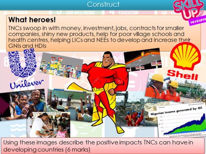
LESSON COVERS:
the positives and negative impacts of TNCs operating in a LIC/NEE (Shell) and the role of international aid (Action Aid). Considering which best assists development.
LESSON INVOLVES:
Students start off by defining TNCs and considering their positive and negative impacts. They then are prompted to focus on the positives using an exam question to practice gleaning information from images. The negatives are presented through a video (hyperlinked - accessible in slideshow mode) and students asked to differentiate between making a point and showing understanding. Aid is introduced by a video (hyperlinked) on Action Aid and then an activity using a differentiated article on a health centre case study. The lesson ends with an exam question.
RESOURCES:
There are 2 articles: the one denoted "MA" is for middle - lower ability, "HA" is for higher ability.
The lesson also includes a 5 minute "Review Previous Learning" task, as a revision tool - feel free to omit or adapt.
Please review with any feedback or if you spot any weevils in the lesson :-)
LESSON COVERS:
DOUBLE LESSON...the cause and result of urban industrial decline and the consequent urban regeneration, as well as the causes of urban sprawl and the advantages and disadvantages of commuter settlements. Case studies used are Bradley Stoke (commuter settlement) and Bristol Harbourside (urban regeneration).
LESSON INVOLVES:
looking at key terms: housing demand, greenfield site, urban sprawl, regeneration, brownfield site. Link to a video to find positives and negatives for developing both greenfield and brownfield sites, with back up photocopy resource. A verbal domino task gives the back story for industrial decline of Bristol's harbourside. Students then create their own dominoes with Q&As on the regeneration of the harbourside and the commuter settlement, Bradley Stoke. Bradely Stoke is explored more with a statement match up task before finishing with an exam question.
RESOURCES:
There are dominoes templates of two different sizes for students who write in different levels of detail/size of handwriting. The case study sheets are saved separately as HIGHER files for more able students, and a DIFFERENTIATED version in simpler text.
NOTES:
probably a double lesson. Youtube video link can be accessed by clicking on the video screen grab while in slide show mode. Dominoes for industrial decline can be handed out and read out for the whol class to hear, or can be given out in pairs or groups.
Please review with any feedback :-)