Thank you for visiting! Here you will find a selection of printable, interactive worksheets for your classroom: Basic Geography worksheets with simple maps, ESL, Spanish, Bible, Reading Comprehension and more. I hope you find the resources useful! Reviews are welcome and very much appreciated. Thank you so much.
Thank you for visiting! Here you will find a selection of printable, interactive worksheets for your classroom: Basic Geography worksheets with simple maps, ESL, Spanish, Bible, Reading Comprehension and more. I hope you find the resources useful! Reviews are welcome and very much appreciated. Thank you so much.
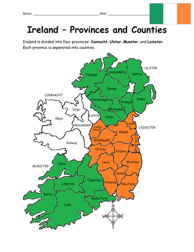
Introduce your learners to the 4 provinces and 32 counties of Ireland! Your students will use the map of Ireland to answer 10 multiple-choice questions on page 2. Answer key included. Basic Geography worksheet with a simple map to introduce the provinces and counties of Ireland. 2 worksheets (plus answer key).
Provinces and Counties included:
Connacht: Galway, Leitrim, Mayo, Roscommon, Sligo
Ulster: Antrim, Armagh, Cavan, Donegal, Down, Fermanagh, Londonderry, Monaghan, Tyrone
Munster: Cork, Kerry, Limerick, Tipperary, Waterford, Clare
Leinster: Carlow, Dublin, Kildare, Kilkenny, Laois, Longford, Louth, Meath, Offaly, Westmeath, Wexford, Wicklow
Thank you so much for using my Geography worksheets! I hope you find them useful. Reviews are welcome and very much appreciated. Please browse this store for a selection of worksheets to introduce your learners to the countries of the world!
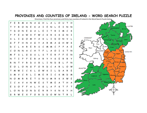
Using the map of Ireland, find the four provinces and thirty-two counties of Ireland in the Word Search Puzzle! They can be found forward or backward.
Provinces and Counties included:
Connacht: Galway, Leitrim, Mayo, Roscommon, Sligo
Ulster: Antrim, Armagh, Cavan, Donegal, Down, Fermanagh, Londonderry, Monaghan, Tyrone
Munster: Cork, Kerry, Limerick, Tipperary, Waterford, Clare
Leinster: Carlow, Dublin, Kildare, Kilkenny, Laois, Longford, Louth, Meath, Offaly, Westmeath, Wexford, Wicklow
One printable word search puzzle (plus answer key).
You may also be interested in:
IRELAND - INTRODUCTORY GEOGRAPHY WORKSHEET
IRELAND - PROVINCES AND COUNTIES INTRODUCTORY WORKSHEET
Thank you so much for using my Geography worksheets to introduce your learners to the countries of the world! I hope you find them useful. Reviews are welcome and very much appreciated.
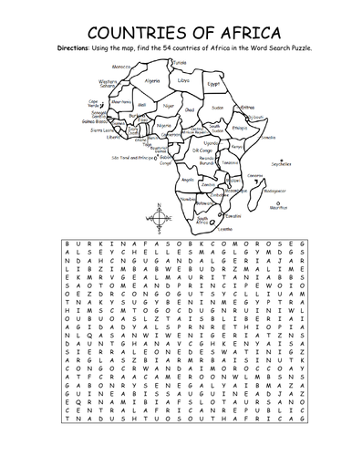
Using the map, find the 54 countries of Africa in this printable Word Search Puzzle! One printable word search puzzle with map (plus answer key).
Countries to find: ALGERIA, ANGOLA, BENIN, BOTSWANA, BURKINA FASO, BURUNDI, CAMEROON, CAPE VERDE, CENTRAL AFRICAN REPUBLIC, CHAD, COMOROS, DJIBOUTI, ESWATINI, GABON, KENYA, EGYPT, EQUATORIAL GUINEA, ERITREA, ETHIOPIA, DR CONGO, CONGO, THE GAMBIA, GHANA, GUINEA, GUINEA-BISSAU, IVORY COAST, LESOTHO, LIBERIA, LIBYA, MADAGASCAR, MALAWI, MALI, MAURITANIA, MAURITIUS, MOROCCO, MOZAMBIQUE, NAMIBIA, NIGER, NIGERIA, RWANDA, SAO TOME AND PRINCIPE, SENEGAL, SEYCHELLES, SIERRA LEONE, SOMALIA, SOUTH AFRICA, SOUTH SUDAN, SUDAN, TANZANIA, TOGO, TUNISIA, UGANDA, WESTERN SAHARA, ZIMBABWE
To introduce your learners to each country of Africa, please browse this store for printable worksheets!
Thank you so much for using my Geography worksheets in your classroom! I hope you find them useful. Reviews are welcome and very much appreciated.
Introduce your students to the countries and capitals of South America! This printable handout of 4 pages includes a list of the 12 countries and capitals and the 3 dependent territories and capitals of South America. Your students will read a brief introduction to South America, write the capital of each country on the map, color the map, and answer the questions that follow. Answer key included.
For worksheets for each country of South America, please check out this discounted bundle: https://www.tes.com/teaching-resource/resource-12525113
Thank you so much for using my Geography worksheets in your classroom! I hope you find them useful. Reviews are welcome and very much appreciated!
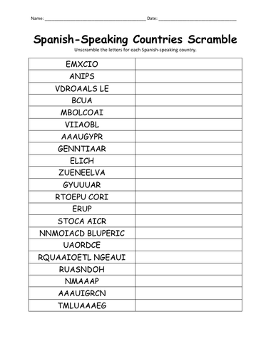
Unscramble each Spanish-speaking country using the list of countries on page 2. Countries included: Argentina, Bolivia, Chile, Colombia, Costa Rica, Cuba, Dominican Republic, Ecuador, El Salvador, Equatorial Guinea, Guatemala, Honduras, Mexico, Nicaragua, Panama, Paraguay, Peru, Puerto Rico, Spain Uruguay, Venezuela. Answer key included.
Thank you so much for using my handouts in your classroom!
Introduce your learners to Italy with this printable handout of two worksheets (plus answer key). Your students will read a brief introduction to Italy (location, capital, flag, language), write ‘Rome’ next to the star on the map to show the location of the capital, color the small map and flag, and use the map and compass to answer 7 questions on page 2. Colored pencils and a pen or pencil are needed for this activity. No other prep needed. Basic Geography worksheet with a simple map to introduce Italy and practice cardinal and ordinal directions.
For use with Interactive Notebooks: After completing the worksheets for Italy, students can cut out the map and flag and paste into the notebook under the topic of Europe/Sub-topic: Italy. Under the map and flag, students can write a summary in their own words of what they now know about this country. Collect worksheets for other countries of Europe to add to the notebook! Please browse this store for a selection of worksheets for other countries of Europe (and beyond!).
Thank you so much for using my Geography worksheets in your classroom to introduce your students to countries around the world! I hope you find them useful and fun. Reviews are welcome and very much appreciated!
Printable handout of the map of the United States. Write the name of each state on the map (the first letter of each state is listed on the map as clues). Answer key included.
Introduce your learners to India with this printable handout of two worksheets (plus answer key). Your students will read a brief introduction to India (location, capital, flag, language), write ‘New Delhi’ next to the star on the map to show the location of the capital, color the small map and flag, and use the map and compass to answer 8 questions on page 2. Colored pencils and a pen or pencil are needed for this activity. No other prep needed. Basic Geography worksheet with a simple map to introduce India and practice cardinal and ordinal directions.
For use with INTERACTIVE NOTEBOOKS: After the worksheets are completed, students can cut out the map and flag and paste into the notebook under the topic of Asia/subtopic: India. Under the map and flag, students can write a summary in their own words of what they now know about this country. Collect worksheets for other countries of Asia to add to the notebook. Please browse this store for a selection of worksheets for other countries of Asia (and beyond!).
Thank you so much for using my Geography worksheets in your classroom! I hope you find them useful. Reviews are welcome and very much appreciated!
India and surrounding: Indian Ocean, Arabian Sea, Bay of Bengal, Pakistan, Afghanistan, China, Nepal, Bhutan, Bangladesh, Myanmar. Official language is Hindi.
Introduce your students to Uganda with two worksheets (plus answer key). Your students will read a brief introduction to Uganda (location, capital, flag, language), write ‘Kampala’ next to the star on the map to show the location of the capital, color the small map, and use the map and compass to answer 8 questions on page 2. Colored pencils and a pen or pencil are needed for this activity. No other prep needed. Basic Geography worksheet with a simple map to introduce the country of Uganda and practice cardinal/ordinal directions.
For use with Interactive Notebooks: After the worksheets are completed, students can cut out the map and flag and paste into the notebook under the topic of Africa / Sub-topic: Uganda. Under the map and flag, your students can write a summary in their own words of what they now know about this country. Collect worksheets for other countries of Africa to add to the notebook! Please browse this store for a selection of worksheets for other countries of Africa (and beyond!).
Thank you so much for using my Geography worksheets in your classroom! I hope you find them useful. Reviews are welcome and very much appreciated!
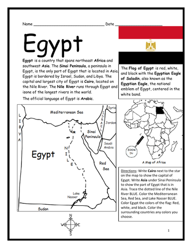
Introduce your students to Egypt with two worksheets (plus answer key). Your students will read a brief introduction to Egypt (location, capital, flag, language), write ‘Cairo’ next to the star on the map to show the location of the capital, write ‘Asia’ under the Sinai Peninsula to show the part of Egypt that is located in Asia, trace the dotted line of the Nile River, color the small map, and use the map and compass to answer 9 questions on page 2. Colored pencils and a pen or pencil are needed for this activity. No other prep needed. Basic Geography worksheet with a simple map to introduce the country of Egypt and practice cardinal/ordinal directions.
For use with Interactive Notebooks: After the worksheets are completed, students can cut out the map and flag and paste into the notebook under the topic of Africa, Asia, or Middle East / Sub-topic: Egypt. Under the map and flag, your students can write a summary in their own words of what they now know about this country. Collect worksheets for other countries of Africa, Asia or the Middle East to add to the notebook! Please browse this store for a selection of worksheets for countries of Africa or Asia (and beyond!)
Thank you so much for using my Geography worksheets in your classroom! I hope you find them useful. Reviews are welcome and very much appreciated.
Introduce your students to Ethiopia with two worksheets (plus answer key). Your students will read a brief introduction to Ethiopia (location, capital, flag, language), write ‘Addis Ababa’ next to the star on the map to show the location of the capital, color the small map, and use the map and compass to answer 8 questions on page 2. Colored pencils and a pen or pencil are needed for this activity. No other prep needed. Basic Geography worksheet includes a simple map to introduce the country of Ethiopia and practice cardinal/ordinal directions.
For use with Interactive Notebooks: After the worksheets are completed, students can cut out the map and flag and paste into the notebook under the topic of Africa / Sub-topic: Ethiopia. Under the map and flag, your students can write a summary in their own words of what they now know about Ethiopia. Collect worksheets for other countries of Africa to add to the notebook! Please browse this store for worksheets for other countries of Africa (and beyond!).
Thank you so much for using my Geography worksheets in your classroom! I hope you find them useful. Reviews are welcome and very much appreciated!
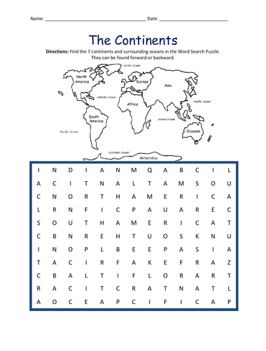
Introduce your students to the 7 continents with this printable handout of 2 worksheets (plus answer key). Your students will write the name of each continent on the map: Africa, Antarctica, Asia, Europe, North America, Oceania (Australia), and South America, trace the line of the equator, color the small map, and use the map and compass to answer 7 questions. Colored pencils and a pen or pencil are needed for this activity. No other prep needed. Basic geography worksheet with a simple map to introduce the continents and practice cardinal and ordinal directions.
For use with Interactive Notebooks: After the handout is completed, students can cut out the map of the 7 continents and paste into the notebook. Under the map, students can write a summary in their own words of what they now know about the continents. Collect handouts for countries of Africa, Antarctica, Asia, Europe, North America, Oceania/Australia, and South America to add to the notebook! Please browse this store for a selection of printable handouts.
Thank you so much for using my Geography worksheets in your classroom! I hope you find them useful!
Find the 7 continents and surrounding oceans in the Word Search Puzzle. They can be found forward or backward: Africa, Antarctica, Asia, Europe, North America, Oceania, South America, Arctic, Atlantic, Indian, Pacific, Southern.
Thank you for using my worksheets in your classroom! Please browse this store for a selection of printable worksheets: Geography, Spanish, Reading Comprehension, Bible, and more.
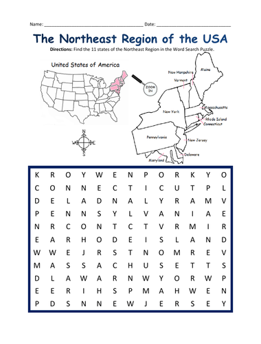
Introduce your students to the NORTHEAST REGION of the United States with this printable handout of one page (plus answer key). Using the map of the Northeast Region, find the eleven states in the word search puzzle: Connecticut, Maine, Massachusetts, New Hampshire, Rhode Island, Vermont, Delaware, Maryland, New Jersey, New York, Pennsylvania.
Other regions also available! Please browse this store for printable handouts for other regions of the United States and other Geography worksheets!
-SOUTHWEST REGION MAP AND WORD SEARCH
-MIDWEST REGION MAP AND WORD SEARCH
-SOUTHEAST REGION MAP AND WORD SEARCH
-WEST REGION MAP AND WORD SEARCH
Thank you so much for using my Geography worksheets in your classroom!
Using the map of the Middle East, fill in the blank letters for each of the 17 countries: Bahrain, Cyprus, Egypt, Iran, Iraq, Israel, Jordan, Kuwait, Lebanon, Oman, Palestine, Qatar, Saudi Arabia, Syria, Turkey, UAE (United Arab Emirates), Yemen.
Thank you for using my printable handouts in your classroom! Please browse this store for a selection of Geography worksheets for countries of the Middle East (and beyond!).
Introduce your learners to the country of CAMBODIA in Southeast Asia with this printable or digital handout of two worksheets (plus answer key). Your students will read a brief overview of Cambodia (location, capital, language, flag), write ‘Phnom Penh’ next to the star on the map to show the capital, trace the lines of the Tonle Sap and Mekong River, color the small map, and use the map and compass to answer 8 true/false questions on page 2. Colored pencils and a pen or pencil are needed for this activity. No other prep needed. Basic Geography worksheet with a simple map to introduce Cambodia and practice cardinal and ordinal directions.
For use with Interactive Notebooks: After your students complete the worksheets, they can cut out the map and flag of Cambodia and paste into the notebook under the topic of Asia / Sub-topic: Cambodia. Under the map, students can write a summary in their own words of what they now know about this country. Collect worksheets for other countries of Asia to add to the notebook! Please browse this store for a selection of printable worksheets for other countries of Asia (and beyond!)
Thank you so much for using my Geography worksheets in your classroom! Reviews are welcome and very much appreciated.
Included: Thailand, Laos, Vietnam, Buddhism, Angkor Wat, Khmer, Mekong River
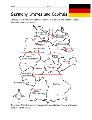
Introduce your students to the 16 states and capital cities of Germany with three worksheets (plus answer key). Using the list of states and capitals on page 2, your students will write the capital city of each state on the map of Germany (page 1). Then answer 8 true/false questions on page 3.
States - Capitals included:
Baden-Württemberg - Stuttgart
Bavaria - Munich
Berlin - Berlin
Brandenburg - Potsdam
Bremen - Bremen
Hamburg - Hamburg
Hesse - Wiesbaden
Lower Saxony - Hanover
Mecklenburg-Vorpommern - Shwerin
North Rhine-Westphalia - Düsseldorf
Rhineland-Palatinate - Mainz
Saarland - Saarbrücken
Saxony - Dresden
Saxony-Anhalt - Magdeburg
Schleswig-Holstein - Kiel
Thuringia - Erfurt
Thank you so much for using my worksheets in your classroom! I hope you find them useful. Reviews are welcome and very much appreciated. Please browse this store for more Geography worksheets!
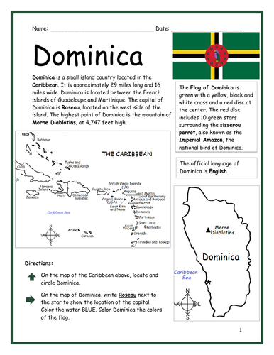
Introduce your learners to the island country of Dominica with two printable worksheets (plus answer key). Simple map activity and reading comprehension questions. Your students will read a brief introduction to Dominica (location, capital, flag, language), locate and circle Dominica on the map of the Caribbean (map 1), write ‘Roseau’ next to the star on the map of Dominica (map 2) to show the location of the capital, color the map, and use the reading passage, maps and compass to answer 10 true/false questions on page 2. Colored pencils and a pen or pencil are needed for this activity. No other prep needed. Basic Geography worksheet with a simple map to introduce Dominica and practice cardinal and ordinal directions. Print and Go!
For use with Interactive Notebooks: After the worksheets are completed, students can cut out the map and flag and paste into the notebook under the topic of (example) The Caribbean / Sub-topic: Dominica. Under the map, your students can write a summary in their own words of what they now know about Dominica. Collect worksheets of other countries of the Caribbean (or North America) to add to the notebook! All available in this store.
Thank you so much for using my Geography worksheets in your classroom! I hope you find them useful. Reviews are welcome and very much appreciated! Please browse this store for more worksheets to introduce your learners to the countries of the world!
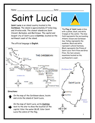
Introduce your learners to Saint Lucia with two printable worksheets (plus answer key). Simple map activity and reading comprehension questions. Your students will read a brief introduction to Saint Lucia (location, capital, flag, language), locate and circle Saint Lucia on the map of the Caribbean (map 1), write ‘Castries’ next to the star on the map of Saint Lucia (map 2) to show the location of the capital, color the map, and use the reading passage, maps and compass to answer 9 true/false questions on page 2. Colored pencils and a pen or pencil are needed for this activity. No other prep needed. Basic Geography worksheet with a simple map to introduce Saint Lucia and practice cardinal and ordinal directions. Print and Go!
For use with Interactive Notebooks: After the worksheets are completed, students can cut out the map and flag and paste into the notebook under the topic of (example) The Caribbean / Sub-topic: Saint Lucia. Under the map, your students can write a summary in their own words of what they now know about this country. Collect worksheets of other countries of the Caribbean (or North America) to add to the notebook! All available in this store!
Thank you so much for using my Geography worksheets in your classroom! I hope you find them useful. Reviews are welcome and very much appreciated! Please browse this store for more worksheets to introduce your learners to the countries of the world!
Included: Petite Piton and Gros Piton.
SPED, Resource Room Teacher, Primary school, elementary.
Introduce your students to Bolivia with this printable handout of two worksheets (plus answer key). Your students will read a brief overview of Bolivia (location, capital, flag, language), write 'Sucre' next to the star on the map to show the capital, color the small map and flag, and use the map and compass to answer 7 questions. Colored pencils and a pen or pencil are needed for this activity. No other prep needed. Basic Geography worksheet with a simple map to introduce Bolivia and practice cardinal and ordinal directions.
For use with Interactive Notebooks: After the handout is completed, students can cut out the map and flag and paste into the notebook under the topic of South America/Sub-topic: Bolivia. Under the map, students will write a summary in their own words of what they now know about this country. Collect handouts for other countries of South America to add to the notebook! Please browse this store for a selection of printable handouts for other countries of South America (and beyond!).
Thank you so much for using my Geography worksheets in your classroom!