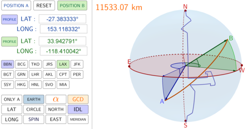


This program will show the Great Circle line between any two GPS coordinates over the surface of the Earth. It has been designed for use in Geogebra v5.0 (install version). Simply enter two GPS coordinates and the program will calculate the great circle distance and sweep angle between your two locations. You can also display a 2D circle in a 3D plane to show students how the Great Circle line wraps around the circumference of the circle.
You can highlight the latitude and longitude components of your GPS locations so that students can easily visualise how this navigation system works. Simply click on the “SPIN” button and your students will get a 360 degree view of the situation. I have also pre-programmed some GPS locations for quick access.
This is an excellent tool to help your students visualise a 3D enivronment on a 2D surface.
Something went wrong, please try again later.
This resource hasn't been reviewed yet
To ensure quality for our reviews, only customers who have purchased this resource can review it
Report this resourceto let us know if it violates our terms and conditions.
Our customer service team will review your report and will be in touch.
£2.00