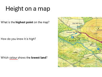


This lesson provides a clear and engaging introduction to height and relief on Ordnance Survey maps. Students first complete a joint task using a realistic OS map extract to identify height through spot heights, colour shading, and contour lines. The lesson then focuses in depth on contour lines, helping pupils understand how maps show the shape of the land and how to recognise steep and gentle slopes. Carefully structured explanations, practical tasks, and clear geographical language ensure students build secure map‑reading skills with confidence. Ideal for KS3 and easily adaptable for KS2.
Get this resource as part of a bundle and save up to 50%
A bundle is a package of resources grouped together to teach a particular topic, or a series of lessons, in one place.
Something went wrong, please try again later.
This resource hasn't been reviewed yet
To ensure quality for our reviews, only customers who have purchased this resource can review it
Report this resourceto let us know if it violates our terms and conditions.
Our customer service team will review your report and will be in touch.
£1.50