Updated version: Only English. Used with students for locational knowledge. Timer already set so you don’t need to press anything and check the students/ control behaviour. You can adjust timer settings.
40minutes - 1hr class: alter to suit your needs/ wants to adjust timing.
This has PPT, an answer sheet for you, 1 page quiz worksheet (or they can write numbers and answers, depending on the ability of students or your resources), a video (which is already embedded in the PPT but you have this as an in case).
Powerpoint is already timed, so you only need to get the class into groups, give them a worksheet and the slides will go through. I monitor the classroom and if they already answered, then I would forward it to next slide to provide more discussion time at end.
Guess the country (flags made with their food)
Name the colours of the flag
Real or Fake flag
Short video clip about flags: memory test
At the end, you can mark answers by going through with students and having them swap their sheets with another group. You can even expand on each section/ answer by asking about the image which brings into cultural food and famous things of each country, or even some facts that students may know.
You can decide how they get full marks. For example, correct spelling only etc. Literacy is important in UK schools and you gain points for correct spelling in exams so you might want to factor your lessons.
I used this for English class where they had to translate it from their own language to English so I didn’t mark for spelling but gave them points for trying to spell (usually they would have the word in their langauge). Their geography level are good so I usually did forward the slides.
I used this as a reward day which is fun, engaging and has competition between teams. You can give rewards to the winning team if you like, usually candy or in UK it would be commendations.
A 2 truths and 1 lie game. There is a total of 5 rounds. Answers are animated to appear when you click. It comes up with the correct fact, or an interesting fact that is related to the statement.
Title with icons. Rules included with images. This makes it understandable for all abilities, including EAL.
2024 statistics. Extremely fun and is perfect.
A range of different GCSE questions to help with subject knowledge, KS4 year 10 and 11 revision skills, and practice exam questions.
Please leave reviews for the resource :)
Tropical Rainforest Information
4 tasks
Team work option (if students are good)
Pair work option (if you need more control)
Homework available if 4th task is too much.
Homework available if all tasks finished.
Height on maps
Gapfill and word banks
Spot height
Layer colouring
Contour lines
Explanation through colour coding, animations and different perspectives
Example drawing
2 minute video summarising
Option to draw contour lines on landscapes
Short tasks
Worksheet applying map skills onto OS map
All answers pop up
Includes higher thinking skills for those who need challenges
Gapfill plenary
Helpsheet available for low ability
Arrived at Manaus (chapter 3 onwards)
Adaptations based on the story.
Literacy based.
Science included.
Worksheet available.
Homework included (unless you want to do in class. It is also differentiated if needed).
Updated shorter version: Climate graph creation using template, and compared or interpreted with climate of South Africa. Lots of scaffolding included and animations step by step (otherwise consider visualiser for some parts). Climate graph template allows them enough to do it on their own with prompts, brilliant for a first time use and repetition if done again or removed as they get use to it.
Climate graphs of different biomes
Read climate graphs
Fill in pyramid task based on biomes
Address misconceptions (lots of images)
Draw climate graphs from blank
Lots of different helpsheets depending on students’ ability - line/ bar/ climate graph template
Pyramid template
Challenges included
Plenary on reading climate graphs, easy to assess
Can be 1hour to 2 hour lesson
2024 Statistics
NASA night lights 2024
Interesting fun facts
Gap fill with word bank
Worksheet available for scaffolding
Definitions of words in detail
Lots of images
Lots of assessment for learning
Visual modelling with students possible
Mind map
Writing task (factors)
Density calculation
Numeracy included
Challenges included
Plenary: challenge both views
Self-assess
Helpsheets available
Both SEN, low ability and high ability covered
Climate graph recap
Map recap using TEA (gapfill, images and prompts)
Pairwork
Literacy task
Optional background information
Optional adjustable information for lower ability (information as hidden slides)
Silent work
Students teach each other
Comprehension
Well controlled activity
Support low ability (with more time/ prompts)
Gap fill
Worksheets
Challenge (can adapt to involve GCSE geography answers instead)
Fun and supportive class activity
Quick plenary to assess all
Spelling test
Introduction (maps)
Adjectives about it
Video
Adjectives now
Discussion about perception - address all the misconceptions
Describe location (gapfill) and challenges
Images and guessing if it’s in the area or not - discussion and address misconceptions again after
Video
Development indicators
Atlas use - engaging and exploring for students (assist if needed e.g. page number after a while)
Fill in the table (challenges included)
Time limit and show answers - address misconceptions
Compare it to UK. Example on board (gapfill). Lower ability can use board example with gapfill. Higher ability can make their own.
Plenary, which statement is a lie. AFL fingers.
Starter: List as many countries in Asia as you can (prior knowledge)
Peer assess, add 5 to list allows them to learn more within cognitive load
Learning intentions (referred to throughout lesson)
Colour coded map and compass. Think/ Pair/ Share
Students act as the teachers and point out the regions.
Gapfill
What do you need to pack on holiday travelling in Asia?
Video
Image prompts to allow time (EAL, lower ability, SEND). Challenge included for others.
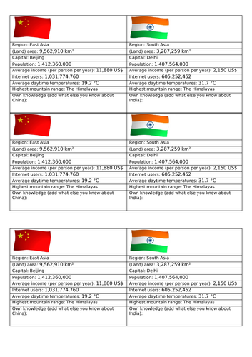
Similarities and differences between China and India (handouts)
Highlight information
Add own facts
2 paragraphs writing (sentence starters)
Answers on board
Bingo key words plenary but teacher uses definitions so students need to think
Fun dingbats game. Example together first.
Learning objectives
Key terms (challenge included)
Explanation - sparse/dense
AFL thumbs
Lots of images - address misconceptions
Information on Asia (China) - Whats the differences discussion
Mind map - example together on board first. (challenge included)
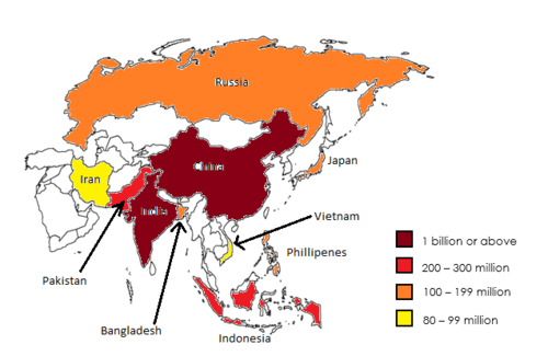
Choropleth map introduction
Create your own (challenge included) - use Atlas
After a while - have countries on board to assist lower ability/ SEND and get them on pace
Answers on board - self check
Describe the distribution - copy example. Students write their own (help lower ability if needed). Challenge included. Having the example already in books allows them to have something available to refer to.
Plenary.
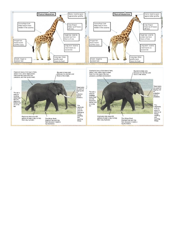
Animals in the Savanna - Lion King Remake of animals - Students well engaged and excited
Learning objectives - command words - meanings
Map of Savanna (students to add to their maps from previous lesson - Physical Geography of Africa). If you don’t have this, the maps (6 to a page) are also included if you wish to make this into an activity to shade in the biome and label the latitudes.
Video about the Savanna - Notes about the biome
Animal adaptation - I do (Lion), We do (Elephant), You do (Giraffe and Warthog). Challenges included.
All students are able to complete giraffe, lower ability may struggle with warthog so I had them think more about the giraffe. Remind them of Pumba from Lion King.
Answers on board - Students to add 3 more to their animals. Handouts available for students who can’t read, lower ability/ SEND to assist them. My students did not stick them in, they used it as help.
YOU ARE A GEOGRAPHER (Science advanced and you create your own animal!)
Choose 3 characteristics (timer them). Explain why those three and how they adapt to the Savanna.
Criteria and levels (on the board I have 5 and 6). On paper (handouts or printouts or you can adapt depending on your class/ student) I have level 3-7 success criteria.
Key words on the board, connectives on the board, challenges on the board, examples (sentences and images) on the board.
Sentence builders (shared between students) allows every student able to complete the task. Higher abilities will not use it but have it as a reference.
Students will be working at different paces due to ability. My higher ability asked to do more characteristics but only because they completed it. My lower ability/ SEND I expected at least 3 sentences (this is because this is in their assessment so they need to have this). Students who finished are able to sketch their animal. Higher rewards given as motivation.
Peer assessing. Students peer assess the presenter (visualiser if you have). We used fingers due to time, but if you have longer lessons or extend another class they can use the peer assessment handouts where students assess themselves, and then peer assess. They can then improve upon feedback.
Many students loved the task, wanted to share and spend their 15 minutes break continuing.
Full terminology
Starter: key term with word bank
Map reading skills
Describe locations
Examples I do, we do, you do
Peer assessment
Hinge questions AFL
Biome information to read - optional methods/ tasks/ printouts if wanted
Map included for biome annotations
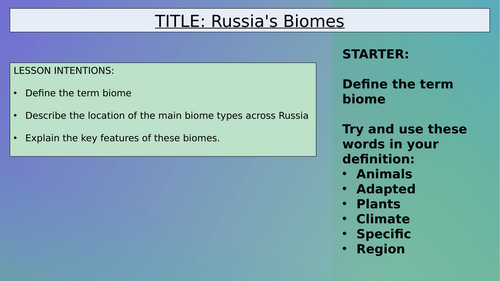
Journey through Russia Map (A, B, C, D)
Describe the biomes, what you see, etc throughout your journey
Success Criterion
Example (I do)
We do - together example
Answers for peer assessment
Plenary
Challenges included: these may be considered “hard” for KS3 but you can teach it or adapt them.
Engaged, fun task. You may need to finish earlier as students tend to not want to finish/ rush and continue/ willing to work into their breaks (but I don’t want them with me at break).
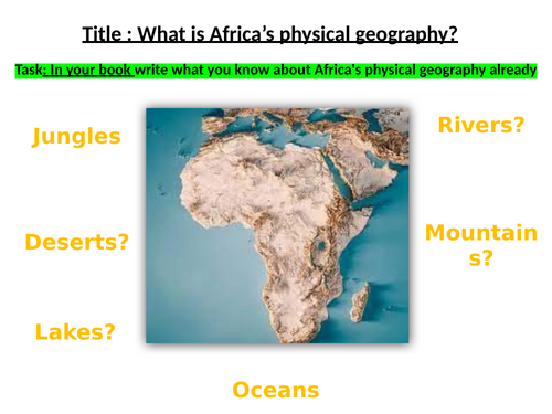
Rivers, Mountains, Deserts, Plains etc.
Prior knowledge check
Video - add to knowledge
Map creation - colour coded and Atlas use
2 versions - 1. blank (students had to really look and discover/ engage with the Atlas), they will ask for help or you can give prompts for harder ones. 2. Marked map (labelled)
Note: I only gave easier maps to students who go to special centres but my low ability and SEND students still did the blank map (they don’t complete it but they learn how to search and use the Atlas well). I did this because it is not in their assessment to know every part and map skills is more valuable for them.
Answers on board for marking
Reading information
Plenary
Extra version of map with key provided for lower ability/ SEND if you wish to use.