Hero image

The Flash Store

Average Rating4.37
(based on 253 reviews)

I am a teacher specialising in Geography and Religious Studies with over 4 years experience to date. I pride myself on designing lessons that engages students in their learning, with an enquiry-based focus being at the forefront. Any lesson that you download is fully resourced and differentiated ready to use in a flash. I hope they make a real contributing to your own classroom like they have done to mine.

221Uploads

259k+Views

349k+Downloads

I am a teacher specialising in Geography and Religious Studies with over 4 years experience to date. I pride myself on designing lessons that engages students in their learning, with an enquiry-based focus being at the forefront. Any lesson that you download is fully resourced and differentiated ready to use in a flash. I hope they make a real contributing to your own classroom like they have done to mine.
Sustainability Starter
occold25occold25

Sustainability Starter

(1)
This is an active starter for pupils when introducing the topic of sustainability. INSTRUCTIONS: Walk around the room finding students who match up to one of these sustainability statements, and then get their signature in the square The first one to get BINGO (horizontal, vertical, diagonal) wins! FEEDBACK: What have you learnt about yourself or other people from this experience? What do all these statements have in common? Why are these things important? Suggest what you think the word ‘sustainability’ means
Food insecurity in Africa
occold25occold25

Food insecurity in Africa

(1)
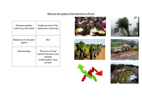
This contains a fully resourced, differentiated lesson on food insecurity in Africa. It focuses on what is meant by food insecurity, its causes and they create an awareness campaign to highlight the issue.
Settlement Test
occold25occold25

Settlement Test

(0)
This contains an end-of-unit test that can be used to assess progress on the core content in a Settlement unit, aimed primarily at KS3 level. This test covers the following topics: settlement hierarchies, services, factors that can affect the site of a settlement, functions of a settlement, Burgess model and urban land use, urbanisation. It can easily be adapted to suit your own school’s local Geography if desired.
What Makes A Good Site For A Settlement
occold25occold25

What Makes A Good Site For A Settlement

(0)
This contains a fully resourced, differentiated lesson on the factors that make a good site for a settlement. The main part of the lesson involves a brief written exercise to consider the factors that are important when considering the site of a settlement, then an interactive group task (involving dice!) where students create the location of a site of a settlement and have to discuss its advantages and disadvantages, and lastly decide whether it is an appropiate site for a settlement or not. Learning Objectives: To describe the factors that can influence the site of a settlement. To explain the advantages and disadvantages of these factors. To evaluate whether these factors make it an appropriate site or not.
How is the UK linked with the rest of the world
occold25occold25

How is the UK linked with the rest of the world

(0)
A fully resourced lesson on how the UK is linked with the rest of the world (interdependance). *Starter- Students listen to the story of Lizzie, and how morning routine is linked to products worldwide. *Main- Students produce an ideas map showing how the UK is linked to the rest of the world, categorising those links. *Main- They then use the task sheet to create an informative poster to explain why countries are reliant on each other for food. *Plenary- What might happen if we cut off our links to the rest of the world?
Sources of Deforestation
occold25occold25

Sources of Deforestation

(0)
This contains a fully resourced lesson on the sources of deforestation, focusing on research, group work and consolidation. Worked very well with my Year 9 groups. Learning Objectives are: To identify different sources of deforestation. To investigate the reasons for deforestation. To draw tentative conclusions about the effects of deforestation.
Treasure Island
occold25occold25

Treasure Island

(0)
This contains a fully resourced, differentiated lesson on consolidating map skills, including compass directions, scale, symbols, and four/six-figure grid references. This is done by students having to create their own treasure islands with a hidden treasure that can only be found by carefully following their designed set of instructions. Learning Objective: To apply map skills learned so far to produce a treasure map.
What Is Geography All About
occold25occold25

What Is Geography All About

(0)
This contains a fully resourced, differentiated lesson which acts as an introduction to Geography at KS3, although it can be easily adapted for KS3. It primarily focuses on the different branches of Geography, in which students have to group different Geographical topics and then explain potential connections between them. Learning Objectives: To describe the different types of Geography. To explain connections between different Geographical topics.
Energy Scheme Of Work
occold25occold25

Energy Scheme Of Work

7 Resources
This contains a fully resourced, differentiated scheme of work on ‘Energy’. All lessons contain a set of clear activities to meet a set of differentiated learning objectives. They should be taught in the following order: Where Does Our Energy Come From? Why Is Using Renewable Energy Important? Are Biofuels Really A Good Source of Energy? What Are The Problems With Using Fossil Fuels? Is Wind Power A Good Source of Energy? (Two Lessons) What Makes A Good Site For A Wind Turbine? Wind Turbine Data Collection Wind Turbine Report (Two Lessons)
What Are The Causes Of Rain In The UK?
occold25occold25

What Are The Causes Of Rain In The UK?

(0)
This contains a fully resourced, differentiated lesson on the causes of rain in the UK. In the main part of the lesson students use a video and information presented on the Powerpoint to explain how each type of rainfall forms - there are three different sheets of varying difficulty to complete depending on how confident each student feels. Learning Objectives: To identify the three types of rainfall and its causes. To explain how it rains in detail. To analyse where the types of rainfall would be found in UK regions.
How Does a Stump Form?
occold25occold25

How Does a Stump Form?

(0)
This contains a fully resourced, differentiated lesson on the sequence of events that leads to the formation of stumps. The main part of the lesson contains a critical thinking exercise where students have to indicate what order they believe the images should be organised in (leading to the formation of a stump), a statement ordering task, and a small group exercise where students construct a model coastline out of plasticine showing how a stump forms. Learning Objectives: To explain the sequence of formation leading to a stump. To recreate this process through the construction of a labelled model.
Coasts Scheme of Work
occold25occold25

Coasts Scheme of Work

11 Resources
This contains a fully resourced, differentiated scheme of work on ‘Coasts’. All lessons contain a set of clear activities to meet a set of differentiated learning objectives. They should be taught in the following order: Why Are Coastlines Important? How Is The Coastline Weathered? How Is The Coastline Eroded? What Causes Waves? How Do Headlands and Bays Form? How Does a Stump Form? What Is Longshore Drift? How Do Spits, Bars and Tombolos Form? How Can We Protect The Coast? How Do Coastal Defences Affect People? Should Happisburgh Be Protected From Coastal Erosion?
The Characteristics of Urban Areas
occold25occold25

The Characteristics of Urban Areas

(0)
This contains a fully resourced lesson which explores the characteristics of urban areas, and how they change from the urban fringe to the central business district. This uses Ipswich as an example, although it could be easily adapted to study other cities.
How Is The Coastline Eroded
occold25occold25

How Is The Coastline Eroded

(0)
This contains a fully resourced, differentiated lesson on coastal erosion. The main part of the lesson involves students producing their own labelled diagrams to show the different ways in which the waves erode the coastline, then do a class quiz-quiz trade (QQT) activity on the factors that affect coastal erosion then complete a written exercise afterwards. Learning Objectives: To describe the different ways in which the coastline is eroded. To explain the different factors that can affect the rate of coastal erosion.
How Do Spits, Bars And Tombolos Form
occold25occold25

How Do Spits, Bars And Tombolos Form

(0)
This contains a fully resourced, differentiated lesson on the main depositional landforms created by longshore drift. The main part of the lesson includes a discussion and written task on how spits form, followed by students using an information sheet to produce their own diagrams as to how bars and tombolos form. Learning Objectives: To understand how the process of longshore drift forms spits. To explain the formation of bars and tombolos.
Contour Island Practical Lesson
occold25occold25

Contour Island Practical Lesson

(1)
This contains a fully resourced, differentiated lesson on contours. This lesson, well situated after a lesson on the basics of contours, involves students creating their own 3D cardboard models to show how contours can show the height and shape of the land. It contains a full set of step-by-step instructions and supporting visuals to assist students with this. Learning Objectives: To identify how contours can be represented through 3D modelling. To describe the relief of your models using appropriate geographical terminology.
How Do We Find Places On A Map (4-Figure Grid References)
occold25occold25

How Do We Find Places On A Map (4-Figure Grid References)

(0)
This contains a fully resourced, differentiated lesson on how to locate features on a map using four-figure grid references. The main part of the lesson involves a brief class demonstration and exercise followed by an independent learning exercise. The plenary involves students competing with each other playing battleships using four-figure grid references.
How Do We Know Where We Are (Geography of the British Isles)
occold25occold25

How Do We Know Where We Are (Geography of the British Isles)

(0)
This contains a fully resourced, differentiated lesson on the key geographical features of the British Isles. The main part of the lesson consists of a mapping task (cities and towns, seas and oceans) which is assessed through an interactive quiz included. It also includes a section on students writing a paragraph to describe the location of an English town using appropriate geographical methodology (this start with a class discussion on how this is best approached to create a list of success criteria on the board), leading to peer assessment as a plenary. Learning Objectives: To plot the key Geographical features of the British Isles. To describe our location using appropriate Geographical terminology.
Why Is It Important To Study Geography
occold25occold25

Why Is It Important To Study Geography

(0)
This contains a fully resourced, differentiated lesson on the importance of studying Geography. It would act particularly well as an early lesson at the start of Year 7. In the main part of the lesson students have to generate their own responses to the question, using small case studies and prompts on the Powerpoint to guide them. This then leads to the second main task where students have to produce a piece of work persuading other Year 7's that it is an important subject to study. Learning Objectives: To explain how Geography can help us to make sense of the world. To analyse how it can affect the actions we make in life.
How Is Africa’s Physical Environment Threatened?
occold25occold25

How Is Africa’s Physical Environment Threatened?

(0)
This contains a fully resourced, differentiated lesson on one way in which Africa’s physical environment is threatened by human activity, namely animal hunting for sport by tourists or wealthy individuals. The main part of the lesson consists of students having to use information cards placed around the room to organise the impacts of hunting (positive/negative for less able, with positive/negative alongside social/economic/environmental categories for more able), a continuum line where students position themselves according to their personal viewpoint on animal hunting in Africa, finished with students drafting a letter to the United Nations (could be amended to an entry in a School Newsletter) where they explain in extended writing form their viewpoint towards animal hunting. Learning Objectives: To explain the impacts of animal hunting in Africa. To evaluate whether you believe animal hunting in Africa should be allowed.