Geography Case Study
We are meant to eat our Five a Day.
The UK only produces 17% of the fruit
and 55% of the vegetables that are bought in British shops.
40% of UK food is produced abroad.
Between 2023 and 2024, the Trussell Trust food banks distributed three million food parcels
to British people.
So what is going on?
This resource includes a variety of lesson activities to pick and choose:
Which Geography keyword (farming types) is the odd one out?
Which grass (cereals) is the odd one out?
In which photo of farming are you most likely to see agrichemicals being used? (vs Golden Rice).
%Ws & 1H - Battery hens (for class discussion).
Comparison of farming today with a 14th c. illustration.
Link to Channel 4 News video: ‘Millions in UK need to double income to escape poverty’.
Lateral Thinking about food supplies - ‘Discuss how these four photographs are linked… Then write three sentences to explain your ideas’ (climate change, floods, empty shekves, container ship).
Development compass worksheet: ‘Food security’.
Info sheet: ‘UK Food Security’ - to help complete…
Question Grid: ‘UK Food Security’.
Role play group sheets:
HM Government
UK farmers
Egyptian farmers
UK families
UK supermarkets
UK food bank organisers
Each sheet has some background info, two possible questions and space for students’ own questions to prepare before the role play itself.
Stakeholders’ conclusions: Worksheet folowing the role play
Worksheet: complete a divided bar graph showing ‘UK Food Imports’. Then students read the text, highlighting the main reasons why the UK’s food security is a problem.
Finally, they write a conclusion to explain what they have learned about the UK’s food security.
Worksheet: ‘Geo-Hexagons: Food Security’ - war, climate, money, Europe, inflation, shopping. Students explain in detail how each image is linked geographically.
Worksheet - Living Graph: ‘UK Households Experiencing Food Insecurity’ (with 20 clues to choose from).
Point, Evidence, Explanation, Link activity - ’ Food Imports to the UK’ (info sheet including proportional area map, worksheet to complete bar graph showing origin of foodstuffs, PEEL worksheet to complete).
Worksheet - ‘True for who? UK Food Security’
Worksheet - deBono’s ‘Six Hats: Food Security in the UK’.
Worksheet - ‘Thought Chains: Food Security in the UK’. Activity trains students to analyse data in detail using connectives. (Imports, sustainability, food bank use in the UK).
Food Security mystery: ‘Why are UK food prices so high?’
32 clues to distribute amongst students. Includes Ukraine War, changing diets, inflation, food waste).
Worksheet - ‘Geography Web: Food Security in the UK’.
Part filled-in to show how students should complete the activity. Links to be made between: Food supplies, the UK, Ukraine, Russia, migrant workers, petrochemicals).
Teachers’ Background Information: Includes links to original BBC article, academic articles.
Geography Case Study
45.5% of the workforce in India are employed in agriculture, and yet only produces 15% of the nation’s wealth.
68% of Indian farmers own less than 1 hectare of land , leading to each farming family receiving an average annual income of less than U$300.
India is the World’s largest milk producer, its dairy herds create (deposit?) 730 million tonnes of manure every year!
So what can be done?
This resource includes a variety of lesson activities to pick and choose:
Photographic Analysis: Maharashtra Farmer making ‘cow cakes’ to dry in the sun before burning as fuel. (Photo & worksheet)
Which energy keyword is the odd one out?
Which chemical compound is the odd one out?
(Both activities promote discussion and thought processes)
Lateral Thinking about Cow dung! (Find ways to link the four images… Then write three sentences to explain your ideas)
Several slides to project to help set the scene (Dezi the Cow from Maharashtra)
Indian Cow Dung Hexagons. (Explain what is NO so good about manure)
Concept Map: ‘Manure to Energy’ - 35 facts to sort and colour code (Locations; Causes; Effects; Management; Supporting Data)
Geography Web: ‘Manure to Energy’ - Using knowledge learned so far, make links between six features (eg Indian dairy farmer, climate change, British citizen) and then explain the links.
Link to video: ‘Biogas: From Grass to Gas’
Annotate the diagram: ‘Dung Power!’ - Two-sided worksheet: a) information to be sorted; b) diagram of an anaerobic digester / bioreactor.
Teachers’ Background Information: Includes links to original BBC article, academic articles
Geography Case Study
NEOM is a planned urban development in north-west Saudi Arabia
When completed it will cover 26,500 km² which is larger than the whole of Wales
Why does Saudi Arabia want to build Neom?
Why is the Huwaitat tribe extremely worried?
Abdul Rahim al-Hwaiti: terrorist or martyr?
This resource includes a variety of lesson activities to pick and choose:
Photographic Analysis: The Line (includes worksheet)
Which Geography keyword is the odd one out?
Which country is the odd one out?
Several slides to project and set the scene (locational knowledge, artists’ impressions of the planned districts)
Links to videos of the Neom development: ‘Saudi Arabia’s mega project’; ‘“The Line” under construction in Saudi Arabia’; ‘Neom: The dark side’
Question Grid: Neom (Who? What? Where? etc, vs is… did… can… etc)
The death of Abdul Rahim al-Hwaiti, a Huwaitat tribesman from the area where the Saudi government wants to build Neom. Abdul posted a video on YouTube saying he did not want money to leave his home. A day later and he was shot dead by the Saudi Army
Concept Map: Neom (35 facts, to be colour coded - Locations; Causes; Effects; Management; Supporting Data
Illustrated glossary: Neom (Peak Oil; Economic diversification; Population density; Desalination plant) - definitions given, students to draw their understanding
Thought Chains: Neom - using knowledge learned so far, students complete boxes (because… and so… Therefore… For example…) to show understanding using scaffolding for higher level answers (eg ‘Saudi Arabia needs to DIVERSIFY its industries…’; ‘The region currently has a POPULATION DENSITY of just 6 people per km²’; ‘Neom is / is not ENVIRONMENTALLY sustainable
(‘Planet’)…’)
Geo-Trinity: Neom - students show similarities and differences between the Saudi government, Huwaitat tribespeople and foreign tourists
‘Six Hats’: Neom: - de Bono’s critical thinking technique
Design a sustainable hotel for Neom - choose five (from twenty-four) features of a sustainable resort, then explain the decision (eg eShuttle buses between the hotel and public transportation hubs; Install ‘smart’ showers that limit their usage to a pre-set time; Stock locally-made Fair Trade hotel souvenirs rather than branded/designer items)
Stakeholders conclusion: Neom - students compare different opinions of the development with their own
Teachers’ background information: links to websites, including the original BBC News story and the official Neom site
Geography Case Study
April - May, 2024
Meteorologists confirmed that Hidaya is the strongest tropical cyclone ever observed in this part of the south Indian Ocean
Floods in Kenya killed 257 and injured 188 people; 56,000 homes destroyed
Activities concentrate on the Mukuru slum in the south of Nairobi
Flooding made worse by: Nairobi built on flood plain by the British colonisers + climate change + Indian Ocean Dipole + informal housing along river banks + saturated soil + impermeable concrete + infilling of Nairobi Dam
5Ws &1H: satellite photo of Tropical Cyclone Hidaya
Which settlement type is the ODD ONE OUT?
Which weather event is the ODD ONE OUT?
Lateral Thinking about the KENYAN FLOODS: Write three geographical sentences linking four photographs
Which photograph shows Kenya? Write a sentence to explain reasoning. (Actually a trick question: They ALL show different aspects of Kenya)
Over a dozen slides to set the scene and prompt discussion: photos of Nairobi and Mukuru, graph showing precipitation (to spot the two rainy seasons)
Links to videos for further knowledge
Mystery: Why did the Mwangi family have to leave their home?
Two slides of clues to help solve the mystery
Worksheet: annotate the map of Nairobi to explain the causes of the floods
Concept hexagons: explain the links between the icons (people, housing, cyclone, rain, flood, death)
Worksheet: Conclusion - Hypothesis “The Kenyan government were right to demolish the houses in Mukuru”
TEACHERS’ BACKGROUND INFORMATION sheets (x2) with further links and detail
Geography Case Study
Lithium is key to green technologies.
The “Lithium Triangle” of Argentina, Bolivia and Chile, holds most of the world’s lithium reserves.
Chinese businesses face allegations of the violation of the rights of local communities, damage to ecosystems and unsafe working conditions.
Argentinian lithium miners surrounded their Chinese managers’ compound and blockaded the entrance with flaming tyres.
This resource includes a variety of lesson activities to pick and choose:
Which Geography keyword is the ODD ONE OUT?
5Ws &1H about Tesla Motors and Elon Musk
5Ws &1H about a photo of lithium salt mounds
In which photo would you be most likely to … meet a worker whose health is at risk?
Critical Thinking: write THREE sentences to LINK these four images (technology: manufacturing, sales, use, waste)
Worksheet and data to construct a dot distribution map of China’s lithium mines around the World
PQE: China’s Lithium Mines - worksheet to analyse the dot distribution map using critical thinking (Patterns, Quantify, Exceptions)
Several slides for screen projection: encourages class evaluation of the positives vs negatives of dot distribution
Slide showing annotated map of Global North vs Global South - encourages analysis of correlation between lithium mining and socio-economic development
Link to video: “Argentina indigenous groups
protest against lithium mining”
Concept Map: The Lithium Triangle (35 snippets of info, to be colour-coded according to Locations, Causes, Effects, Management, Supporting Data)
The concept map info can then be used for:
Thought Chains: The Lithium Triangle - complete the scaffolding to complete six pieces of analysis…
“Chinese firms have been buying lithium mines in South America because…”
“The lithium mining industry in South America is SOCIALLY unsustainable because…”
“The lithium mining industry in South America is ECONOMICALLY unsustainable because…”
“The lithium mining industry in South America is ENVIRONMENTALLY unsustainable because…”
“Electric car makers buy Chinese lithium-ion batteries because…”
“Electric cars are not yet completely sustainable because…”
Geography Web: The Lithium Triangle
Pupils link feature and analyse the connections between the Lithium Triangle and China, Argentina’s government, indigenous people, Tesla Motors
TEACHERS’ BACKGROUND INFORMATION sheets (x3) with links to relevant articles and original BBC News story
Geography Case Study
Hoad’s Wood, near Ashford in Kent, is a site of specialscientific interest (SSSI).
Parts of the nature reserve have experienced serious damage from unconsented felling and fly-tipping of waste material, including hazardous material.
All natural features are presently lost and the ground level has been raised by several feet.
This resource includes a variety of lesson activities to pick and choose:
Which organism is the ODD ONE OUT ?
ILLUSTRATED GLOSSARY: ‘Pollution’ worksheet
PHOTOGRAPHIC ANALYSIS worksheet
QUESTION GRID: Hoad’s Wood (5Ws &1H)
TRUE FOR WHO?
Link to TV spotlight on Hoad’s Wood pressure group
Six worksheets for CLASS ROLE PLAY (local builder, mobile tyre fitter, local family with young children, local Residents’ Association, Kent Police Force, Kent Wildlife Trust)
Hoad’s Wood (stakeholders’ conclusion) worksheet
TEACHERS’ BACKGROUND INFORMATION (3+ pages)
Each page is set up so there is room to add revision notes. The idea is that each page contains one case study so that exam revision can be condensed and is hopefully generic enough for any school’s chosen case studies. Topics are straight from the AQA syllabus…
TECTONIC HAZARDS IN A DEVELOPED COUNTRY
TECTONIC HAZARDS IN A DEVELOPING COUNTRY
TROPICAL STORMS
EXTREME WEATHER IN THE UK
CLIMATE CHANGE IN THE QUATERNARY PERIOD
SMALL SCALE UK ECOSYSTEMS
TROPICAL RAINFORESTS
HOT DESERTS
COLD ENVIRONMENTS
COASTAL LANDFORMS IN THE UK
COASTAL MANAGEMENT IN THE UK
RIVER LANDFORMS IN THE UK
FLOOD MANAGEMENT SCHEMES IN THE UK
GLACIAL LANDFORMS IN THE UK
TOURISM IN A GLACIATED UPLAND AREA OF THE UK
A MAJOR CITY IN A DEVELOPING COUNTRY
IMPROVING QUALITY OF LIFE FOR THE URBAN POOR
A MAJOR CITY IN THE UK
AN URBAN REGENERATION PROJECT
GROWTH OF TOURISM IN DEVELOPING COUNTRIES
RAPID ECONOMIC DEVELOPMENT (Parts One & Two)
SUSTAINABLE INDUSTRY IN THE UK
A LARGE-SCALE AGRICULTURAL DEVELOPMENT
SUSTAINABLE FOOD AND WATER IN DEVELOPING COUNTRIES
A LARGE-SCALE WATER TRANSFER SCHEME
EXTRACTION OF FOSSIL FUELS
RENEWABLE ENERGY IN DEVELOPING COUNTRIES
GEOGRAPHICAL APPLICATIONS: PHYSICAL FIELDWORK
GEOGRAPHICAL APPLICATIONS: HUMAN FIELDWORK
GLOSSARY OF KEY GEOGRAPHICAL TERMS IN THE AQA SYLLABUS
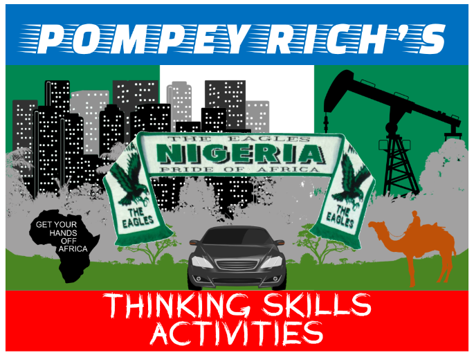
I have made a range of topic-specific resources based upon activities in David Leat’s ‘Thinking Through Geography’. They can be dropped into individual lessons or into a ‘Nigeria’/‘Africa’ scheme of work.
NIGERIA OR BRITAIN
Pairs of images for students to discuss, with interesting Nigerian trivia
WHAT COMES NEXT?
Six sets of Nigeria-related photos to discuss and suggest the next feature
ODD-ONE-OUT
Six sets of Nigeria-related keywords, place names, etc. Can be used as starters
LATERAL THINKING
Six Nigeria-related dilemmas to solve (if possible!)
ODD-ONE-OUT
Six sets of Nigeria-related images, can be used as starters
LIVING GRAPH
Choose 10 clues from 20 to annotate graphs of Nigeria’s oil revenues
MIND MOVIE STORYBOARD
Script (and images) about a family affected by the oil industry in the Niger Delta
CLASSIFICATION
32 facts about malaria in Nigeria to sort into a Case Study sheet
MOST LIKELY TO…
Six sets of Nigeria-related photos with a decision making element
WHO? WHAT? WHY? WHEN?
Photos of Nigeria to help formulate ‘W’ questions and prompt discussion
IT’S A MYSTERY
32 facts for a pair-share activity about high-level corruption in Nigeria
MIND MOVIE SCRIPT
The story of a Nigerian migrant attempting to reach Europe
THOUGHT CHAINS
Using a concept map about the Great Green Wall to construct logical analysis
HEXAGONS AND GEOG WEB
Make links to explain terrorism (Boko Haram, Niger Delta Avengers) in Nigeria
MAKING A…
Choose from a menu of features to design a sustainable Sahelian school
DECISION MAKING
Use a variety of resources to choose a low tech way to halt desertification
ROLE PLAY
Resources to help decide if the Eko Atlantic development should be completed
Reading Photos
Twelve photos to promote discussion and connect Geographical features
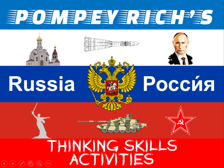
I have made a range of topic-specific resources based upon activities in David Leat’s ‘Thinking Through Geography’. They can be dropped into individual lessons or a ‘Russia’ scheme of work.
RUSSIA OR BRITAIN
Pairs of images for students to discuss, with interesting Russian trivia
WHAT COMES NEXT?
Six sets of Russia-related photos to discuss and suggest the next feature
ODD-ONE-OUT
Six sets of Russia-related keywords, place names, etc. Can be used as starters
LATERAL THINKING
Six Russia-related dilemmas to solve (if possible!)
ODD-ONE-OUT
Six sets of Russia-related photos, can be used as starters
LIVING GRAPH
Choose 10 clues from 20 to annotate demographic graphs of Russia
MIND MOVIE STORYBOARD
Script (and images) about the the volcanoes and industry in Kamchatka
CLASSIFICATION
32 facts about the Siberian industry to sort into a Case Study sheet
MOST LIKELY TO…
Five sets of Russia-related photos with a decision making element
WHO? WHAT? WHY? WHEN?
Photos of Russia to help formulate ‘W’ questions and prompt discussion
IT’S A MYSTERY
32 facts for a pair-share activity about the Russian annexation of Crimea
MIND MOVIE SCRIPT
Choices facing a Nenets teenager in rapidly-developing Siberia
THOUGHT CHAINS
Using a concept map about Siberian Tigers to construct logical analysis
HEXAGONS AND GEOG WEB
Make links to explain the effects of climate change on Russia’s Polar Bears
MAKING A…
Choose from a menu of features to design a sustainable Black Sea resort
DECISION MAKING
Use a variety of resources to decide on the best Russian city for UK tourists
ROLE PLAY
Resources to help decide on the exploitation of Siberian fossil fuel reserves
Reading Photos
Twelve photos to promote discussion and connect Geographical features
I have made a range of topic-specific resources based upon activities in David Leat’s ‘Thinking Through Geography’. They can be dropped into individual lessons or a ‘China’ scheme of work.
WHAT COMES NEXT?
Four sets of China-related photos to discuss and suggest the next feature
ODD-ONE-OUT
Six sets of China-related keywords, place names, etc. Can be used as starters
LATERAL THINKING
Six China-related dilemmas to solve (if possible!)
ODD-ONE-OUT
Six sets of China-related photos, can be used as starters
LIVING GRAPH
Choose 10 clues from 20 to annotate demographic graphs of China
MIND MOVIE STORYBOARD
Script (and images) about the plight of the Uyghurs in China
CLASSIFICATION
32 facts about the Great Sichuan earthquake to sort into a Case Study sheet
MOST LIKELY TO…
Five sets of China-related photos with a decision making element
WHO? WHAT? WHY? WHEN?
Photos of China to help formulate ‘W’ questions and prompt discussion
IT’S A MYSTERY
32 facts for a pair-share activity about the effects of the Three Gorges Dam
MIND MOVIE SCRIPT
The immediate after-effects of a typhoon hitting the Yangtze Delta
THOUGHT CHAINS
Using a concept map about Foxconn electronics to construct logical analysis
HEXAGONS AND GEOG WEB
Make links to explain China’s territorial claims in the South China Sea
MAKING A…
Choose from a menu of urban features to design a sustainable Chinese city
DECISION MAKING
Use a variety of resources to locate a new electronic car factory in China
ROLE PLAY
Resources to help decide on ‘Pandas or profit’ in China
Reading Photos
Twelve photos to promote discussion and connect Geographical features
Powerpoint and activities investigating how reservoirs help secure water supplies (but also damage the environment)
“Chat/info stations” about the Three Gorges Dam in China:
Location
Water supply
Sediment
Waste
Wildlife
Forced migration
Each info station has Blooms and 9-1 differentiated questions/activities
eg Grades 1-2 (Knowledge): Describe the location of the Three Gorges Dam. Make a list of the ways in which the Three Gorges Dam has harmed Chinese wildlife
Grades 8-9 (Evaluation): Explain the criteria you would use to assess the siting of the Three Gorges HEP project. Justify your choice of ONE animal to protect that is endangered by the Three Gorges Dam
Powerpoint and activities outlining how deforestation and mining provide energy but also damage the environment
Blooms and 9-1 differentiated questions/activities
eg Grades 1-2 (Knowledge): (a) Use the data to complete the two divided bar graphs (causes of tropical deforestation & global energy consumption). (b) Fill in the blanks on the separate sheet to analyse your completed divided bar graphs
Grades 8-9 (Evaluation): (a) Read about firewood, mining, fracking and biofuels (highlight the main environmental effects as you go). (b) Compare and evaluate the effects of those four human activities. (Write three paragraphs for 8 marks)
Completing and analysing divided graphs
Find out why humanity’s growing demand for energy supplies can lead to deforestation
Find out how human activities involved in the energy industry can cause serious environmental damage
Powerpoint and activities outlining how the mechanisation of farming and commercial fishing provide food
Blooms and 9-1 differentiated questions/activities
eg Grades 1-2 (Knowledge): You each have at least one clue… swap ideas to help you complete the following task. Describe how modern farming affects the environment by completing the labels surrounding the photo
Grades 8-9 (Evaluation): Use the picture of ‘The Environmental Effects of Commercial Fishing’ to: (a) Identify six problems caused by fishing (number them on the picture). (b) In your book, assess the harm done to ocean ecosystems by trawlers, then explain the criteria you would use to assess the six impacts
Find out how the farms we get our food from damages the environment (annotate photo)
Find out how eating fish causes damage to the environment
Powerpoint and activities outlining the factors leading to demand outstripping the supply of food, energy and water
Blooms and 9-1 differentiated questions/activities
eg Grades 1-2 (Knowledge): Complete the line graph showing World population growth. Describe how the World’s population has changed since 1800 (try to write two paragraphs for 6 marks)
Grades 8-9 (Evaluation): Complete the line graph showing Global water consumption’. Complete the table showing ‘Global oil extraction’. Which resource (oil or water) would be the most important to find new source for the 21st century? Justify your answer
Drawing and analysing line graphs
PLEASE NOTE: the TES preview does not display the font correctly!
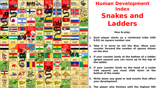
Based on the classic game
Players move around the board trying to develop their country
Move up the ladders and down the snakes according to geographical events
Squares based on real countries and their 2018 HDI scores
Took the idea from geographypods.com and made my own version
(Suggest board is printed A4 and laminated)
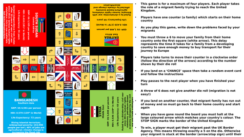
PLEASE NOTE: the TES preview does not display the font correctly!
Based on the classic game but with added random event cards
Players try to get their migrant family from the home country to the UK
Random events represent the problems of international migration
Includes board, rules and event cards
(Suggest the board is printed A4 and then all parts are laminated)
Factors affecting tourism
Resort Life Cycle Model
Blackpool coastal resort case study
Lake District UK tourism case study
Positive and negative mass tourism impacts
Kenya mass tourism case study
Tourism in extreme environments
Antarctica extreme tourism case study
Ecotourism
Sarawak, East Malaysia ecotourism case study
Migration in richer and poorer countries
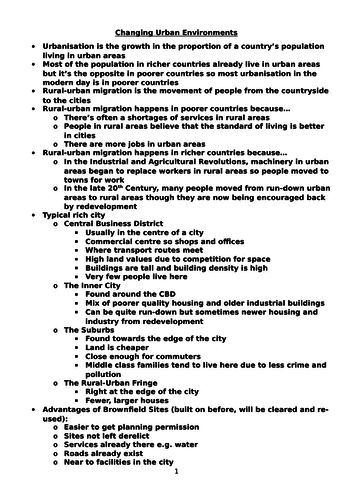
Typical rich city model (CBD, inner city, suburbs, rural-urban fringe)
Brownfield and greenfield sites
Problems in richer urban areas
Solutions to tackle housing shortages in richer urban areas
Revitalising CBDs
Ethnic segregation
Dharavi, Mumbai, India squatter settlement case study
Environmental issues with urbanisation in richer countries
Air pollution
Water pollution
Sustainability in cities
Birmingham CBD development case study
Newcastle inner city redevelopment case study
Vauban, Freiburg, Germany sustainable cities case study
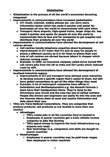
ICT and transportation improvements
Call centres abroad
Localised industrial regions
Advantages and disadvantages of TNCs
Apple Inc case study
Reasons for increased manufacturing in Newly Industrialising Countries
China manufacturing case study
Impacts of producing more energy
Impacts of producing and importing more food
Renewable energy
Spain wind energy case study
Kyoto Protocol