I'm a teacher and the Author of the Amazon e-book;' Time Smart Teaching' and my mission is to create Geography resources to help teachers save time and reduce their workload. I am sharing additional time saving tips for teachers on my YOUTUBE channel ' Time Smart Teaching' if you fancy dropping by!
I'm a teacher and the Author of the Amazon e-book;' Time Smart Teaching' and my mission is to create Geography resources to help teachers save time and reduce their workload. I am sharing additional time saving tips for teachers on my YOUTUBE channel ' Time Smart Teaching' if you fancy dropping by!
Differentiated resource to allow students to show what they know about the causes effects and solutions to climate change (global warming).
There is a level assesment criteria and a writing frame to help less able students.
Suitable for years 7 and 8
This resource has been brought to you by the author of the Amazon Kindle ebook ’ Time Smart Teaching: 8 Insider Tips to reduce your workload that Schools don’t tell you!. 100% free for Amazon Unlimited subscribers and available to download at the following link;
https://www.amazon.co.uk/Time-Smart-Teaching-Insider-Workload-ebook/dp/B082ZBLFQQ/ref=sr_1_1?keywords=time+smart+teaching&qid=1577972903&s=digital-text&sr=1-1
The introductory chapters are FREE to read on my tes shop page.
Land use refers to what is built on the land at a specific point or the way in which humans use it; for example- residential, industrial, commerce and so on. Land use patterns vary considerably between HIc’s and Lic’s and this lesson examines the Hoyt and Burgess model with a focus task on Brazil. Students must place phototgraphs around their models base on their knowlege of land use patterns. They will start with a quick recap on keywords linked to the theme of urbanisation and urban environments. Fiinally a 4 mark exam question wil test their ability to compare land use between HIc’s and LIC’s. Written for the older AQA GCSE Geography syllabus, but still relevant today.
A bundle of map skills activities for KS3 classes, of mixed ability including using maps to create stories, and analyse human and physical landscapes. Map skills developed includes reading contour lines, using compass directions, concordant coastlines, maps symbols to describe land use and grid references with scale.
Map skills are enabling people to make sense of the world around them by studying spatial patterns and change in a variety of natural and man made landscapes.
This 6th lesson in our cold climate series aimed at year 7 / 8 examines why Arctic sea ice is reducing year on year due to climate change. Students develop their timeline skills to collect information on how ice cores show changes in air quality over time. Students then utilise their completed time line on sea ice to answer questions to test their understanding of the issues presented in the lesson.
Monitoring Climate Change in the Oceans - Geo-stationary Satellites Lesson for Year 9
A full lesson looking at how geo-stationary satelites are used to monitor the impact of climate change in our oceans and a worksheet with questions linked to an article on GIS technology within the NOAA (National Oceanic and Atmospheric Administration).
Description:
Dive into the world of climate change monitoring with our comprehensive lesson on the utilization of geo-stationary satellites. Tailored for year 9 students, this resource offers an in-depth exploration of how these satellites play a pivotal role in understanding and tracking the impact of climate change in our oceans.
Key Features:
Cutting-Edge Technology: Uncover the advanced capabilities of geo-stationary satellites in monitoring climate change, specifically focusing on their application in oceanic studies.
Interactive Learning: Engage students with a well-crafted worksheet, featuring questions linked to an article on GIS technology within the NOAA (National Oceanic and Atmospheric Administration).
Literacy and Reading skills developed. DART activity designed to get students reading and understanding the text.
Adaptable for Higher Ability KS3 Classes: While designed for year 9, the lesson is versatile and can be effectively used with higher-ability KS3 classes.
Why Choose This Resource?
Real-World Application: Connect classroom learning to real-world scenarios by exploring the practical applications of geo-stationary satellites in climate change research.
Critical Thinking: Develop critical thinking skills through the worksheet, encouraging students to analyze and comprehend GIS technology within the NOAA.
Adaptability: Suited for various class levels, ensuring an inclusive learning experience for both year 9 students and higher ability KS3 classes.
Ideal for:
Geography teachers aiming to integrate current technology and climate change into their lessons.
Educators seeking a resource that aligns with year 9 curriculum objectives and challenges higher-ability KS3 students.
Enhance your geography class with this insightful lesson on geo-stationary satellites and GIS technology. Download now to empower your students with knowledge about climate change monitoring in our oceans!
Unveiling the Mysteries of Global Atmospheric Circulation - GCSE Geography Lesson Plan
Description:
Demystify the complexities of global atmospheric circulation with our comprehensive lesson and worksheet designed to support GCSE geography students. This resource is crafted especially for middle and lower ability pupils, providing a clear and simplified understanding of the intricate mechanisms behind atmospheric circulation, including the heating effect of the equator and the spinning effect.
Key Features:
Concept Simplification: Tackle the challenges students face in comprehending global atmospheric circulation by breaking down complex physical processes into accessible components.
Hands-On Learning: Engage students with a whole-class person model activity, offering a dynamic and interactive approach to understanding the global atmospheric system.
Teamwork Skills: Foster collaboration and teamwork as students work together to create a tangible representation of atmospheric circulation, enhancing both their comprehension and interpersonal skills.
Relevance to Biomes: Establish a foundation for future lessons on global biomes by ensuring students grasp the fundamentals of low and high-pressure systems and their geographical implications.
Why Choose This Resource?
Targeted Support: Tailored for middle and lower ability pupils, this lesson plan provides the necessary scaffolding to boost understanding and confidence.
Practical Application: Reinforce theoretical concepts through hands-on activities, promoting active learning and retention.
Preparation for Advanced Topics: Lay the groundwork for the study of global biomes by ensuring students grasp the fundamentals of atmospheric circulation.
Ideal for:
GCSE geography teachers focusing on concept clarification and foundational knowledge.
Educators seeking engaging activities to make complex topics accessible for all students.
Enhance your geography class with this invaluable lesson resource. Download now to simplify global atmospheric circulation and pave the way for deeper insights into the world’s biomes!
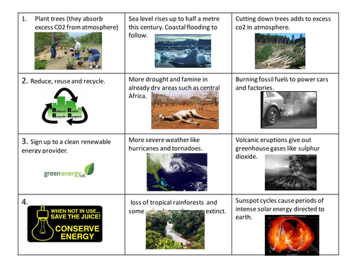
Unveiling the Complexities of Climate Change - GCSE Geography Lesson with True or False Plenary
Description:
Explore the multifaceted factors influencing climate change with our comprehensive lesson designed to align seamlessly with the new Oxford blue GCSE textbooks. Delve into the intricate world of global temperature fluctuations, examining not only the impact of increased CO2 emissions but also the intriguing influences of super volcano eruptions and solar cycles.
Key Features:
Comprehensive Understanding: Equip your students with an in-depth knowledge of the greenhouse effect and various natural causes contributing to both global warming and cooling.
Textbook Synergy: Aligned with the new Oxford blue GCSE textbooks, this lesson seamlessly integrates with existing coursework, providing a supplementary and enriching learning experience.
Engaging Plenary: Wrap up the session with an interactive TRUE or False plenary, allowing students to consolidate their understanding in a lively and enjoyable manner.
Bonus Link: Enhance learning beyond the classroom with a bonus lesson link to a documentary, offering students a deeper exploration of the topics covered.
Why Choose This Resource?
Holistic Perspective: Move beyond textbook theories and explore a range of factors influencing climate change, offering students a more comprehensive understanding.
Interactive Assessment: Reinforce learning through an engaging TRUE or False plenary, promoting active participation and knowledge retention.
Ideal for:
Geography teachers looking to enhance climate change education with a well-rounded perspective.
Educators seeking engaging and interactive resources to complement standard textbooks.
Elevate your geography classroom with this illuminating lesson on climate change causes. Download now to empower your students with a nuanced understanding of global temperature dynamics!
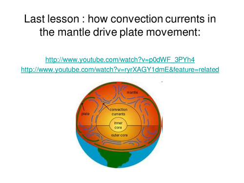
Full lesson looking at the different properties of tectonic boundaries. Students extend and finish the mind map example based on the information provided in the powerpoint.
This resource has been brought to you by the author of the Amazon Kindle ebook ’ Time Smart Teaching: 8 Insider Tips to reduce your workload that Schools don’t tell you!. 100% free for Amazon Unlimited subscribers and available to download at the following link;
https://www.amazon.co.uk/Time-Smart-Teaching-Insider-Workload-ebook/dp/B082ZBLFQQ/ref=sr_1_1?keywords=time+smart+teaching&qid=1577972903&s=digital-text&sr=1-1
The introductory chapters are FREE to read on my tes shop page.
A pond is an example of a small-scale ecosystem that we typically student at GCSE Geography. Pond ecosystems depend on balance and equllibrium of all the interdependant parts that make it up; both the living ( biotic) and non-living ( abiotic). This lesson presumes you are lucky enough to have a pond on, or close to your school site to visit and carry out the field sketching tasks. However, if not, there is a detailed picture of a pond ecosystem on the slide they can copy if needed. Students start with a discussions, recap on producers, consumers and decomposers ( this lesson assumes a base-line understanding on food chains). Students sketch the pond with guidance and label appropriately using the mini-beasts spotter card to help them identify animals found on the pond, or through pond-dipping There is an exit card/ small write up task at the end.
Nowadays food is produced, shipped and consumed on a global scale. No longer are people eating only locally sourced food. The complex system of imports, exports and food packaging and processing, along with climate change, all impacts on food surplus or shortages accross the world. In the GCSE Geography AQA specification student must be aware of 3 natural resources and how they are managed; food water and energy. This full lesson examines 6 key factors that impact on food supplies in 2 contrasting places ; South Sudan and Mongolia. both places experiencing food shortages for different reasons. The starter task involves student examining a GIS map where the impacts of climate change on food shortages are the biggest. Then students complete a match-up task to link causes and impacts of food shortages in 6 key areas: conflict, climate change, technology, pests, water stress and pverty. There is AFL activity by way of a 6 mark exam questions with structured help for lower and middle abilities and a mark scheme with a model answer. Finally a true or false plenary to finish.
From an Ofsted Outstanding provider, and author of the popular ebook*** ’ Time Smart Teaching’ : 8 Insider Tips to reduce teacher workload that schools don’t tell you! ***available exclusively on Amazon Kindle, and 100% free for those on the unlimited subscription.https://www.amazon.co.uk/Time-Smart-Teaching-Insider-Workload-ebook/dp/B082ZBLFQQ/ref=sr_1_1?keywords=time+smart+teaching&qid=1577920252&s=digital-text&sr=1-1
This full lesson explores the producers, consumers and decomposers in a pond, aquatic ecosystem. Pond ecosystems are small, yet dynamic, and sensitive to change. It helps if you have access to a pond for sketching but it is not essential. Students will analyse a pond food web to pick out individual food chains. They will be able to identify producers, consumers and decomposers and explain how interdependance works in this ecosystem between the biotic and abiotic parts.
This full lesson and accompanying graded homework sheet explore the characteristics of the world’s most populated urban areas; megacities. Those places with a population of 10 million inhabitants or more are becoming increasingly common in the developing world. The lesson includes a starter, video question sheet for Andrew Marr’s Megacities series, episode 1 Link below;
https://www.youtube.com/watch?v=USktb5cXdRs
There is a full answer sheet given for the video questions.
The homework sheet asks students to analyse the proportional symbols megacities maop, and has a 6 mark exam style question and mark scheme. This should be done after watching the video and completing the lesson, but could also serve as a stand-alone revision activity.
Manchester is a rapidly growing economic centre in the heart of Northern England. It is therefore an appropriate case study example to study for the GCSE Geography ‘Urban Issues & Challenges’ topic for the AQA spec. This internet research and study lesson focuses on 6 key characteristics of Manchester ( tourism, education, culture, Industry, Transport & religion), and how they come together to build the city as an important both nationally and globally. There are website links for each of these factors, so this lesson is suitable for home-study if needed. There is a grid for students to make notes on all 6 key areas. This lesson was originally designed so that small groups could each take a factor, and go away and build a presentation to bring back to the rest of the group. In that way, they become experts on one specific facet of the city. This framework could easily be adapted for a different HIC case study, if desired.
In this 5th lesson in our cold climate series ’ Pol to Pole’ and following on from lesson 4 on extreme tourism in the Antarctic Cruise, learners examine human impacts on cold climates and Antarctica. Students main task is to evaluate which human threats are the most pressing and urgent, but completing a diamond 9 activity. Students could then follow this up by writing an international code of conduct for Antarctic scientists and visitors.
This building-off-grid project is ideal for delivery in the classroom for years 8 through to 11 or set as an independent task for distance-learning or home-based study. Also suitable for celebrating ’ Earth Day’ in April with a focus on reducing carbon footprint. Since being stuck on lock-down I have been binge-watching episodes of USA based TV-series like ’ last of the Alaskans’ and ’ Building off Grid’ which follow families as they design and self-build their own cabins and earth-ship style homes in remote areas of Arizona and Alaska. The aim is to live sustainably and in harmony with the landscape and ecosystem around them.
This lesson / project will help GCSE/ KS4 students make connections in their learning with the Geography ’ Living World’ topic, especially around explaining how humans have adapted to the opportunities and challenges of living in extreme conditions such as the Tundra Biome and the Hot Desert regions. Students could easily talk about home design and crop growing/ subsistence farming in their examinations following the AQA spec A curriculum.
The students must choose where they want to live their off grid lifestyle; either Arizona or Alaska, and the Power Point goes through the benefits and drawbacks of doing so in each ecosystem. There are video links to relevant video content showing some aspects of cabin-building in both of these environments.
Then students enlist 3 helpers to help build their cabin, and roll a dice to determine their allocated budget they can use to buy materials for the cabin project. Using this budget, they can chose from a ‘menu’ worksheet of construction options to custom-build their cabin. They have a choice of sketching out their design with a floor plan, or actually building a model of their cabin from lego/ cardboard/ paydough etc. If submitted as a distance learning activity it would be great to make it into a competition, and invite students to submit pictures of their designs electronically for display. There are some ideas for follow-on activities on the slides.
Written for year 7, this lesson has a literacy focus and introduces students to some of the physical geography and landscape characteristics of the Tundra Biome and it’s cold environment. Students analyse the descriptive vocabulary and adjectives used to describe Svalbard, then build a bank of keywords as a class to use independently in their travel writing. The aim of the lesson is to complete an extended piece of writing to take the reader on an imaginary journey through the tundra around the archipelago of Svalbard ( travel journalism skills). There is a writing frame worksheet to support students write about the physical and human geography using the 5 senses. This differentiated lesson could easily be adapted for year 8 or 9 and gets student familiar with cold environments at GCSE geography.
Threats to the tropical rainforest stem from population pressure and climate change. This fragile biome is used for subsidence farming mineral extraction and hydro-electric power. This code breaking resource can be used to introduce threats for the first time, or as a revision activity. This worksheet is designed for Edexcel B specification, however it is suitable for AQA also/ The completion requires access to the textbook 'Edexcel geography B - pages 270-271 in the Pearson Textbook by John Hopkin et al ISBN: 9781446927762. ( page copy available with this resource) The resource is a reading comprehension exercise where they find relevant information from the 2 page of text and images.
This full lesson and associated worksheets examine the causes effects and responses to his UK based extreme weather flooding event. This lesson includes a fact file of key information like dates, times and damage impacts to help students complete a case study mind map or overview sheet. Could be used as a revision exercise or introducing this natural hazard event for the first time.
In this 3rd lesson on our cold environments series ’ Pole to Pole’ we explore how the resourceful and hardy ’ Nennet’ tribe have made a lifestyle herding reindeer throughout Siberia, Russia. Students must use their geographical enquiry skills to gather information about the tribe through an information hunt activity, building in kinathstetic learning experiences into the classroom. There is a link to video content from Simon Reeve’s 'Russia ’ series in which he faces frost nip whilst travelling with the tribe.
This full lesson gets students thinking about describing and explaining where most of the world’s ice is found. The Tundra biome is found at far north and south latitudes where the days are short and the winters are long. Permafrost and taiga forests are located here and only well adapted plants and animals survive, hence the name ’ treeless mountain tract’. The lesson has a differentiated map task where student must shade and label places within the tundra biome. There is also a match-up activity where they must link up definitions of icy landscape features with their pictures: glaciers, ice sheet, ice caps and snow patches.