


This lesson is part of Exploring Spain, a Geography unit designed for upper KS2 students (Y4-6), but can also be taught as a stand alone lesson.
The presentation first shows students how to work out a 4-figure grid reference.
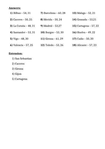
The activity then challenges students to describe the position of different cities in Spain using 4-figure grid references. It is differentiated two ways:
Easier – Students locate Spanish cities using 4-figure grid references (with clues).
Harder – Students locate Spanish cities using 4-figure grid references.
Extension – Students identify Spanish cities using compass direction and grid reference clues.
If you like this resource, we would appreciate a review! We will happily send you a free resource in return for a review or useful suggestions/feedback. Contact us at ed@teachitforward.co.uk.
Get this resource as part of a bundle and save up to 58%
A bundle is a package of resources grouped together to teach a particular topic, or a series of lessons, in one place.
Something went wrong, please try again later.
Brilliant resource.
Brilliant and resourceful activity for children. Next time for the extension you can include some human features for children to identify as a consolidating of what they’ve learnt about the physical and human features
Report this resourceto let us know if it violates our terms and conditions.
Our customer service team will review your report and will be in touch.
£2.00