


This interesting and highly-stimulating lesson enables students to create their very own African country geography study presentations. The lesson format and resources enables them to engage with varied geographical concepts including biomes, population, rivers, lakes, mountains, climate, borders and capital cities.
The lesson follows a clear, logical, bite-size learning journey, which guides students towards relevant and constructive learning objectives, and helps them to build their presentations. Over the course of this journey, they:
-Remember key facts about the African continent to contextualise their learning;
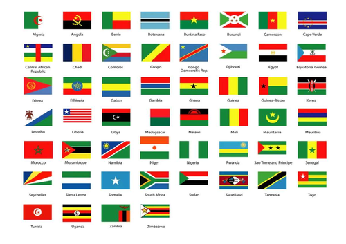
-Pick an African nation at random;
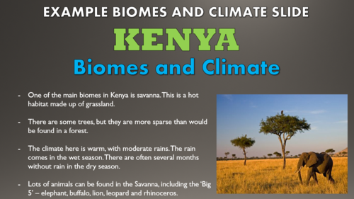
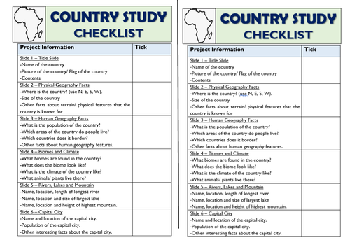
-Follow a clear checkist and model example, enabling them to create presentations with the following sections: Physical Geography Key Facts, Human Geography Key Fact, Biomes and Climate, Rivers, Lakes and Mountains, and Capital City.
-Presenting their country study, with reference to clear guidance on effective speaking and listening skills.
-Self-assess their outcomes using the learning objectives.
The lesson benefits from access to atlases and/or web-searching devices.
This lesson resource is made up of a visually engaging whole-lesson PowerPoint presentation (17 slides), the countries for selection, and the checklist.
The resources within this lesson can be easily adapted to suit home/remote learning.
Get this resource as part of a bundle and save up to 61%
A bundle is a package of resources grouped together to teach a particular topic, or a series of lessons, in one place.
Something went wrong, please try again later.
This resource hasn't been reviewed yet
To ensure quality for our reviews, only customers who have purchased this resource can review it
Report this resourceto let us know if it violates our terms and conditions.
Our customer service team will review your report and will be in touch.
£2.00