docx, 1.61 MB
docx, 1.61 MB
pptx, 8.77 MB
pptx, 8.77 MB

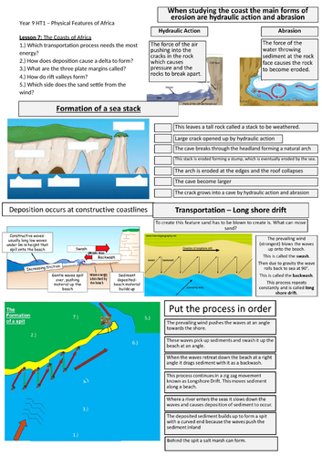
Students will start by recapping hydraulic action and abrasion then identify features using aerial photography of headlands and bays. Students then recap the types of weathering that is present and then describe the formation of a sea stack. Finally students will learn about the formation of a spit and using terms such as longshore drift, swash and backwash they will attempt at explaining its formation.

Starter: Knowledge Retention of previous learning
Task 1: Using aerial photography identify the feature on the African coast
Task 2: Describe the types of weathering present along the coast
Task 3: Explain the formation of a sea stack.
Task 4: Describe the location of features of a spit.
Task 5: Describe the formation of a spit.
Task 6: Plenary: Recap of home learning expectation.

Lesson contains one powerpoint and one worksheet.

Get this resource as part of a bundle and save up to 40%

A bundle is a package of resources grouped together to teach a particular topic, or a series of lessons, in one place.

Bundle

Physical Features of Africa - KS3 (Key Stage 3)

For KS3 geography, this bundle is great for Year 9 in their first term back at school. This helps to get students familiar again with physical geographical concepts of rivers, coasts, climate, sand dunes and plate tectonics. This bundle also contains a tutorial on GIS mapping for students to have a go mapping Africa to see its physical features. This bundle contains 7 lessons that are fully resourced, with powerpoints and worksheets. Throughout the series of lessons, students will firstly begin by using GIS to map the physical features of Africa and identify its location globally as well as its individual countries. Then students will go through the climate and misconceptions of Africa along with creating a climate graph and manipulating and using data. Next students will recap the water cycle, transportation and erosion to learn about Delta formation, specifically in the context of the Niger Delta. Then switching the plate tectonics students recap the theory and structure of the Earth before investigating shield and composite volcanoes as well as the African Rift Valley. Finally students learn about the formation of sand dunes and how they bring tourist opportunities as well as headlands, bays and spit formation along the African coastline. Lesson 1: Mapping Africa using GIS Lesson 2: Physical Features of Africa Lesson 3: The Climate of Africa Lesson 4: The Niger Delta Lesson 5: The East African Rift Valley Lesson 6: Sand Dunes at Sossusvlei Lesson 7: Coasts of Africa Students will gain a variety of skills such as data collection and manipulation along with creation of graphs and reading OS maps. This bundle contains fully resourced lessons along with worksheets.

£8.42

Reviews

Something went wrong, please try again later.

This resource hasn't been reviewed yet

To ensure quality for our reviews, only customers who have purchased this resource can review it

Report this resourceto let us know if it violates our terms and conditions.
Our customer service team will review your report and will be in touch.