


Part of our amazing ten lesson Rainforest Topic, aimed at Lower KS2. Available on TES as a bundle for £10 or for download as individual lessons
- Clear teaching PPT illustrating where on the map of the world the lines of tropics are, explaining the difference between tropical and temperature rainforests and what they mean.
-Engaging main activity to find and mark tropical rainforests on the map of the world with three levels of differentiation, some will work towards finding both tropical and temperate rainforests and understanding that tropical rainforests lie within the lines of tropics. - Continent maps with tropical and temperate rainforests marked on for students to use as reference points when plotting rainforests on their world map.
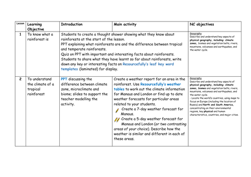
Geography
- Locate the world’s countries, using maps to focus on Europe (including the location of
Russia) and North and South America, concentrating on their environmental regions,
key physical and human characteristics, countries, and major cities - Identify the position and significance of latitude, longitude, Equator, Northern
Hemisphere, Southern Hemisphere, the Tropics of Cancer and Capricorn, Arctic and Antarctic Circle, the Prime/Greenwich Meridian and time zones (including day and night)
Get this resource as part of a bundle and save up to 43%
A bundle is a package of resources grouped together to teach a particular topic, or a series of lessons, in one place.
Something went wrong, please try again later.
This resource hasn't been reviewed yet
To ensure quality for our reviews, only customers who have purchased this resource can review it
Report this resourceto let us know if it violates our terms and conditions.
Our customer service team will review your report and will be in touch.
£3.50