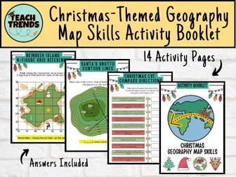
Fun and visually attractive, this Christmas themed atlas work sheet is great for end of term group activities. All you need is an atlas.
A double sided Christmas themed activity sheet. Activities include: finding capital cities, finding countries, locating oceans, using data sets, drawing flags and using geographic language to describe locations - most with a festive theme. Also: draw a snowman, draw a Christmas tree and name all nine of Santa's reindeer.
Included is a display slide with learning objectives and outcomes, an activity slide with instructions, teacher notes and a lesson plan.
This resource was featured by the TES in their blog last year, and recieved a 5* review.
This work booklet guides pupils through vital mapping skills by giving them a ‘how to guide’ as well as a chance to practise their new skills in a variety of questions and tasks. The booklet is aimed at children in upper KS2 and lower KS3 and can be easily adapted to suit. The booklet can be given at the end of a unit of work or spread out across several lessons.
The mapping skills included in this work booklet include:
4 Figure Grid References
6 Figure Grid References
Compass Directions
Contour Lines
Calculating Scale
Each topic above includes a one-page ‘how to guide’ and well as a corresponding 'activity sheet.'
Download is in pdf format.
Are you ready to turn this holiday season into a global adventure for your young explorers? Introducing our enchanting Christmas-themed geography map skills activity booklet, specially crafted for curious minds aged 10-14!
Festive Learning Fun: Transform geography lessons into a holiday celebration! Each activity is designed to weave Christmas magic into essential map skills, making learning both educational and joyous.
Engaging and Age-Appropriate: Tailored for 9-12 year olds, our activities strike the perfect balance between challenge and entertainment. Watch as your child hones their map-reading skills while embracing the holiday spirit.
Santa’s Global Adventure: Follow Santa’s journey around the world! From the North Pole to bustling cities and exotic landmarks, each activity unveils a new destination, fostering cultural awareness and geographical knowledge.
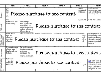
Map Skills Included:
Grid References
Scale & Distance
Compass Directions
Contour Lines
Time Zones
A total of 14 activity pages with answers included.
Geography Skills – Map Skills & Symbols
This is a full lesson PP that is part of a humanities curriculum covering History and Geography strands. This lesson is ready to teach and can be used as part of the whole unit that I have uploaded, but each is a standalone lesson so can be taught alone. This lesson covers symbols on maps
Up to date worksheet for map skills for any Geography curriculum and Key Stage.
Includes:
4fig grid references
6fig grid references
direction
compass
scale
map symbols
and more
I’ve put together a homework booklet focusing on the Maths and Statistics skills needed for the 9-1 GCSE Geography courses. There are 13 different homework’s that I’ve been setting and then using as a discussion to start the lesson.
There are homeworks on the following topics -
Bar Charts
Compound Bar Charts
Pie Charts
Scatter Graphs
Interpreting and Using Data
Maps and Grid References
Population Pyramids
Averages
Thank you for taking the time to look at my resources, please feel free to leave any feedback, all help is greatly appreciated.
Thanks Shaun
A knowledge organiser for some of the numeracy skills that students studying GCSE Geography (AQA) may be asked to use in exams.
It’s a 2 page document which includes:
definition of each numeracy measure
step by step guide on how to calculate it
a worked/model example for each
advantage and disadvantage for each measure
top tip reminders
Includes the following numeracy/statistical skills:
mean (average)
median
mode
range
percentage change
interquartile range
A map skills homework booklet for use with KS3 Geography classes.
An amalgamation of worksheets I have gathered over the years to create a comprehensive and easy to mark Map Skills Homework Booklet!
Enhance your pupils’ geographical skills with a series of interpretation and analysis sheets and questions. This resource includes 8 PowerPoint slides with corresponding questions all focused on a different data presentation method. Ideal for preparing your pupils for exams and revising analysis skills. The high quality slides include annotation, examples and five scaled-ability questions.
The data presentation skills included in this resource are:
Climate Graphs
Population Pyramids
Choropleth Maps
Scatter Graphs
Pie Charts
Demographic Transition Model
Proportional Symbols Map
Divided / Stacked Bar Charts
Resource downloaded in PDF and PowerPoint Format.
Geography Skills – What is geography?
This is a full lesson PP that is part of a humanities curriculum covering History and Geography strands, as well as Literacy. This lesson is ready to teach and can be used as part of the whole unit that I have uploaded, but each is a standalone lesson so can be taught alone. This lesson covers what the subject it.
Celebrate Christmas this winter with your secondary Geography students with this 54 question xmas quiz for 2024 themed around the event complete with answers in both quick and question by question format. This resource is 54 question Xmas quiz spread across 5 different rounds. It is created on Microsoft Powerpoint and suitable for KS3 and KS4 secondary students.
Whats included?
Within this resource there are 54 questions spanning 5 rounds. A mixture of multiple choice, general knowledge and picture quiz questions. Topics range from Christmas traditions from around the world, flag picture round, capital city and country matchups, Christmas themed Geographical knowledge in addition to skyline picture round.Your learners will have so much fun engaging with this quiz.
Delivery and timings
The answers can then shared as a class by going through each question individually (ensure you are in present mode for the correct answer to colour yellow and the transitions to work) for students to peer or self mark. Additionally, answers to each individual question can be found on the notes section of each individual PowerPoint slide.
If you choose to deliver this in a single session - it could take upto (but not in excess of) an hour to complete depending on how much thinking time you decide to give your students. However, the rounds have been sectioned off within the Powerpoint so that you could potentially delivered a round or two at a time with your classes or tutor groups over the period of a week or two.
Looking for more Christmas resources?
Check out this Christmas anagram worksheet activity
Humanities Christmas Quiz
Christmas Quiz
Christmas Dingbats resource
FREE Seek and Find Christmas resource
#geography #christmas #christmasquiz #xmas #xmasquiz #geographyquiz
How to guide for pupils GCSE AQA Skills.
Maths (mean, median, mode, range, percentage increase, interquatile range)
Map Skills
Graph skills
4 and 6 grid references
OS Maps and symbols
Each includes a how to page and then example questions for pupils to practice
The complete, student-friendly guide to mastering statistical skills in A Level Geography.
Statistics (particularly Question 2 in Edexcel Paper 3) is often the area where students lose the most marks simply due to a lack of confidence. This 56-page, beautifully designed booklet demystifies the maths by explaining all six required statistical tests entirely within a geographical context.
Instead of abstract numbers, students learn how to calculate standard deviation using Sahel rainfall data, and how to perform a Mann-Whitney U test on inner-city vs suburban environmental quality scores. ( although not in the Edexcel Spec ) this stats test is a really useful one for the NEA.
What’s Included?
The “Choosing the Right Test” Framework, especially useful for NEA
A simple, visual decision tree helping students identify exactly which test to use based on what they want to find out (Difference, Correlation, Dispersion, or Association).
A complete history table showing which statistical test has appeared in every Edexcel Paper 3 from the Specimen through to 2024.
Step-by-Step Guides for All 6 Tests
Each test includes a full explanation, the formula, a step-by-step calculation guide, and a fully worked geographical example:
Standard Deviation (Sahel rainfall data)
Inter-Quartile Range (GDP per capita)
Spearman’s Rank Correlation (Haiti economic vs social data — actual 2024 Paper 3 data)
Chi-Squared Test (Landlocked countries and development — actual 2020 Paper 3 data)
Mann-Whitney U Test (Environmental quality scores)…useful for students with regard to the NEA, but not actually in the specification.
Student’s T-Test (Pebble sizes on exposed vs sheltered beaches)
Critical Values & Interpretation
Critical value tables included for Spearman’s Rank, Chi-Squared, Mann-Whitney, and T-Test.
A foolproof 4-step framework for interpreting results geographically and accepting/rejecting the null hypothesis.
Past Paper Questions Archive
Every Q2 statistics question from the Edexcel Specimen paper through to 2024, organised by year with the exact wording and data context.
Revision Checklist
A 15-point self-assessment checklist for students to track their statistical confidence.
Why buy this resource?
Written for Geography, not Maths: Every example uses real-world geographical data, helping students understand why we use the test, not just how to do the maths.
Independent revision: Perfect for homework, flipped learning, or as a reference guide to keep in their folders all year.
High-quality design: Professionally formatted, visually engaging, and easy to read.
Format: High-quality PDF, ready to print or share digitally via your school’s VLE.
(Note: While designed with the Edexcel Paper 3 specification in mind, the statistical skills covered are universal and highly applicable to AQA, OCR, and Eduqas NEA/NEA coursework).
Geography Skills – Types Of geography
This is a full lesson PP that is part of a humanities curriculum covering History and Geography strands. This lesson is ready to teach and can be used as part of the whole unit that I have uploaded, but each is a standalone lesson so can be taught alone. This lesson covers the different types of geography
GCSE Geography Paper 3 workbook for AQA 2026 pre-release (Water). Includes 3 fully planned lessons (Figures 1–3), map/data skills, exam questions, mini mocks, mark schemes and model answers. Builds AO2/3 skills and confidence with 6 & 9 markers.
Edexcel B GCSE Geography – Exam Skills Revision Booklet
This Exam Skills Revision Booklet is an essential resource for students preparing for the Edexcel B GCSE Geography exams. It is designed to strengthen students’ geographical skills, boost confidence, and improve exam technique across all papers.
What’s Included?
Exam-Style Questions – A variety of structured questions to develop key exam skills.
Past Paper Questions – Real exam questions to help students familiarize themselves with the exam format.
Mark Schemes & Examiner Insights – Clear guidance on how to achieve top marks, including common mistakes to avoid.
Statistics & Data Interpretation Questions – Practice with graphs, charts, and numerical skills essential for the exam.
Geographical Skills Questions – Map reading, fieldwork application, and problem-solving tasks.
Excellent for Homework & Revision – Ideal for independent study, intervention groups, or in-class practice.
This booklet is perfect for revision sessions, structured homework, or exam practice
A whole set of lessons to cover all geographical skills. Differentiated and challenge activities throughout. Excellent for teaching first time, recapping or revision.
Designed around OCR A specification, however all skills included are fundamental parts of geography regardless of the specification.
This will save you a lot of time and planning!!
A big lesson with lots of opportunity for differentiation and engagement, as well as paired or group work.
Basically, students learn how to describe places, and then apply this skill. It would work well as a skills building lesson in KS3, or as an end of term type lesson with either KS3 or KS4.
There are differentiated resources for lower and higher, and a number of ways in which the activities could be undertaken (which are in the lesson plan). There are teacher notes and a lesson plan. The activities are clear, and there are Superstar extension activities.
---
The main aim is…
This is a big lesson which could be used as an end of term activity, or as a skills building lesson.
Students either learn or develop their geographical terminology and then apply / demonstrate using photos of actual places.
Key ideas and content…
We can describe places using geographical language.
It is more effective to use the correct key terms and descriptive language.
To differentiate…
Pass the sheets round on a timer, with the challenge of either adding more key terms or improving existing ones.
Stick the sheets on the wall around the room, give each student a different key term to look for. Students go round the room.
Insist on certain terms being applied.
To extend…
Insist on a description of features which aren’t necessarily visible.
Students find their own photos and analyse them.
Peer assessment.
There are some tricky terms in the key terms activity, use to stretch students.
To assess…
Discussion points.
The work produced.
Peer assessment opportunity.
Full unit of work for map skills and the UK. This unit explores compass points, 4 and 6 figure grid references, scale, distance, longitude, latitude and other core map skills, alongside the UK. All lessons are suitable for 50 minutes to 1 hour of teaching time. Includes supporting worksheets for lessons - no additional resources are required. Most suitable for KS2, years 5 or 6.
All lessons have a starter and lesson aim. All PowerPoints in the same signature style.
Lesson sequence:
1 – Introducing maps
2 – Where is the UK?
3 – Compass points
4 – Map symbols
5 – 4 and 6 figure grid references
6 – Scale and distance
7 – Atlas skills
8 – Longitude and latitude
9 – Design a treasure map
10 – ICT Mapzone
11 – UK and Europe flags
12 – Migration
13 – Human vs physical features
Also includes Geography Literacy mat and Geography Numeracy/Map Skills mat, as well as an extension sheet pack with homework’s and activities to extend pupil skills and knowledge.
Links to National Curriculum:
- Locate the world’s countries, using maps to focus on Europe (including the location of Russia) and North and South America, concentrating on their environmental regions, key physical and human characteristics, countries, and major cities
- Name and locate counties and cities of the United Kingdom, geographical regions and their identifying human and physical characteristics, key topographical features (including hills, mountains, coasts and rivers), and land-use patterns; and understand how some of these aspects have changed over time
- Identify the position and significance of latitude, longitude, Equator, Northern Hemisphere, Southern Hemisphere, the Tropics of Cancer and Capricorn, Arctic and Antarctic Circle, the Prime/Greenwich Meridian and time zones (including day and night)
A word search featuring 29 keywords from the ‘Geography Skills’ topic.
This resource is perfect as a starter or plenary activity within an introduction to geography scheme of work aimed at year 7 students or early KS3.