Mountain Landforms and Geomorphic Processes WorksheetQuick View
TutorCloud

Mountain Landforms and Geomorphic Processes Worksheet

(0)
PDF Download (Not Editable) 
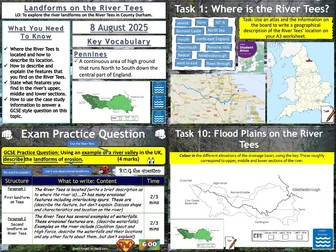
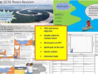
Enhance your geography lessons with our ‘Mountain Landforms and Geomorphic Processes Worksheet’. This comprehensive resource is meticulously designed to develop a range of critical thinking and analytical skills among your students. Featuring a wide variety of engaging exercises, this worksheet aims to improve word meaning, inference, summarising, analysis and evaluation, content evaluation, structure comprehension, retrieval skills, prediction, explanation, exploration, as well as comparison and synthesis abilities. The content is structured to challenge students at various cognitive levels, catering to different learning styles and abilities within the classroom. By integrating this resource into your lessons, you can provide your students with a stimulating learning experience that encourages active participation and deepens their understanding of mountain landforms and geomorphic processes. The PDF format ensures easy accessibility and convenience for both teachers and students. It allows for hassle-free distribution and can be utilised across multiple devices without compromising the layout or quality of the content. Download our ‘Mountain Landforms and Geomorphic Processes Worksheet’ today and elevate your geography teaching to new heights. Equip your students with the skills they need to excel academically while fostering a love for learning about the dynamic world of geography. Invest in quality education resources that inspire and challenge students. Download our worksheet now and witness the profound impact it can have on your classroom dynamics and student engagement. Experience the difference with our teaching resources. Download the worksheet now!
Glaciation: Transportation and Depositional LandformsQuick View
markthegeographer

Glaciation: Transportation and Depositional Landforms

(0)
AQA GCSE Geography lesson for the latest specification Unit 1B: In this lesson we look at transportation and depositional landforms such as moraines, drumlins and erratics. The starter is glaciation-themed retrieval quiz. We then look at the idea of the glacial conveyor belt, what glacial till is and what the difference between sorted and unsorted material is and why they form in different environments. The pupils create diagrams of both. We then consider moraines and the different types of moraines. The pupils have a diagram to annotate and label. We then consider drumlins, the pupils again create diagrams and learn why they show direction of movement and collective called ‘basket of eggs’ topography. We then briefly look at erratics and how they can also show the history of glacier movement. We finish with a 4 mark GCSE-style exam question with guidance on how to answer it. Hope this saves you some valuable planning time. https://www.tes.com/teaching-resources/shop/markthegeographer
GCSE Geography - Geomorphic processesQuick View
GeogTeacherUK

GCSE Geography - Geomorphic processes

(0)
Complete lesson - Linked to OCR 2016 Geography syllabus Based on Hodder textbook PowerPoint self explanatory Do it Now task - review of UK landscapes learning Definition of geomorphic processes Weathering - physical, chemical, biological, freeze-thaw, carbonation, oxidation Mass movement - rotational slip, mudflow, rockfall Four types of erosion Four types of transportation Extended question on transportation with model answer 11 question review of learning with answers
Geo: Landscapes and LandformsQuick View
tcorcoran2102

Geo: Landscapes and Landforms

(0)
This engaging and curriculum-aligned Year 7 Geography resource introduces students to landscapes, landforms, and Geomorphic processes through clear explanations, real-world case studies, and interactive activities. Covering topics like plate tectonics, erosion, weathering, and the cultural and economic value of landscapes, it includes videos, map skills, and creative tasks such as designing hazard-resilient towns and planning a class tour to Uluru. Perfect for building foundational geographical knowledge, critical thinking, and a connection to both Australian and global environments. 35 lessons worth of content including a formattive and summative assessments.
Coastal Landforms, Longshore Drift, Stacks and Sea Defences WorksheetsQuick View
bethgrace2312

Coastal Landforms, Longshore Drift, Stacks and Sea Defences Worksheets

(1)
Coastal Landforms and Sea Defences Included in this resource: Worksheet 1 - Headlands and bays label activity Key definitions of the types of erosion Identifying caves, arches, stumps and wave-cut platforms Arranging the statements for the formation of wave-cut platforms Worksheet 2 - Longshore drift description activity Features of a spit Famous landforms recall Key definitions linked to longshore drift Worksheet 3 - Importance of sea defenses on tourism, construction, wildlife etc. Hard and soft coastal engineering Advantages and disadvantages of sea defenses Beach Nourishment and managed retreat comparison Set up in A4, these three worksheets come with a full set of comprehensive answers. Ideal to be used as an introductory, summary or revision task. I have also used this as a homework activity to support pre-teaching this topic. No previous knowledge of landforms or defenses is required for students to complete this. Please note there may be American English spellings in this resource i.e. ‘defenses’ Please feel free to ask any questions - Thanks!
Rivers: Landforms on The River TeesQuick View
markthegeographer

Rivers: Landforms on The River Tees

(1)
AQA GCSE Geography lesson for the new specification Unit 1C: In this lesson we look at landforms of the River Tees in North-East England. We start with a retrieval practice grid based on the content learned so far in the unit. The lesson is based on an A3 worksheet and the students complete tasks on the worksheet starting with the upper section features and landforms and working our way down to the mouth in the lower section. There are supporting slides and videos for each of the ten tasks on the worksheet. We finish with a 4-mark GCSE-style question where the students can use the information gained during the lesson within the context of an exam question. Hope this saves you some valuable planning time. https://www.tes.com/teaching-resources/shop/markthegeographer
OCR river landform formationQuick View
Lovelearninggeography

OCR river landform formation

(1)
** Formation of waterfalls, gorges, meanders, levees, floodplains etc ks3 ks4** A collection of resources to help students understand geomorphic processes (paper 1). Easy to follow if non-specialist. Specific to the OCR ks4 spec. An interactive power point and exam questions. This resource will help your students learn the formation of river landforms. Information covered: waterfalls, gorges & rapids Meanders & Ox-bow lakes V-shaped valleys & interlocking spurs Floodplain and Levees Suitable for ks3 ks4. The resources can be used on its OWN or with the other resources. The power point is vibrant and interactive. The power point can be used on a white board or with a projector. They have animations and moving objects. The power points are easy to use and explain. Sources on the power point. REMOVE THE WATERMARK AND THE FILES ARE THE SAME AS THE COVER PICTURE If you are looking for vibrant, interesting and fun activities…….take a look at my other resources. I have created power points on background to rivers, geomorphological processes and the river case study. I will be adding lots of new resources. Follow me and thank you if you have time to give me feedback. Hope your class loves learning with my resources :)
Rivers Bundle: Processes, Landforms and FloodsQuick View
TheGeographyOasis

Rivers Bundle: Processes, Landforms and Floods

7 Resources
This bundle focus on the content of a traditional GCSE Rivers unit and includes 6 sets of resources: River Drainage Basins River Processes- erosion, transportation and deposition River Landforms of the Upper Course River Landforms of the Middle Course River Landforms of the Lower Course River Floods The resources could be used for: In class activity Pre-class flipped learning Post class homework and consolidation To support EAL students To support students who benefit from short, structured activities. The resources are aimed at GCSE students although it could be suitable for KS3. The content covers key elements of the majority of examination syllabus including AQA, Edexcel, WJEC and Cambridge International. The resources focus on comprehension of key knowledge and processes. They include a mixture of activities including gap fills, definitions, diagrams and questions. Each worksheet is supported with a PowerPoint that can be displayed in class and includes possible answers. Resources can be used electronically or hard copy.
Coastal Processes and LandformsQuick View
cchisim521

Coastal Processes and Landforms

(0)
An introduction to coasts, waves and coastal processes. This is suitable for GCSE Geography courses where coasts are a part of the specification.
Coastal Landforms- formation and processQuick View
wgenterprise

Coastal Landforms- formation and process

(7)
The powerpoint presentation contains annotated photographs taken by the author of the Dorset Jurassic coastlines most famous features. The presentation can be used as an 'aide-mémoire' for revision purposes or as an introduction to the work of waves in the formation of coastal features.
Coasts Bundle: Processes, Landforms, and Management.Quick View
TheGeographyOasis

Coasts Bundle: Processes, Landforms, and Management.

5 Resources
This bundle focus on the content of a traditional GCSE Geography Coasts unit and includes 5 sets of resources: Waves (constructive and destructive) Coastal processes- Erosion and Transportation Erosional Landforms- Bays, Headlands, Caves, Arch, Stack, Stump, Wave-cut Platform Depositional Landforms- Beaches, Spits, Bars, Tombolos, Sand Dunes Erosion and Management- The Holderness Coast, Sea defences, Mappleton. The resources could be used for: In class activity Pre-class flipped learning Post class homework and consolidation To support EAL students To support students who benefit from short, structured activities. The resources are aimed at GCSE students although it could be suitable for KS3/5. The content covers key elements of the majority of examination syllabus including AQA, Edexcel, WJEC and Cambridge International. The resources focus on comprehension of key knowledge and processes. They include a mixture of activities including gap fills, definitions, diagrams and questions. Each worksheet is supported with a PowerPoint that can be displayed in class and includes possible answers. Resources can be used electronically or hard copy.
Glacial Processes & LandformsQuick View
man_moss

Glacial Processes & Landforms

(0)
Edexcel B SOW Can be used either on its own or for editing purposes. There are roughly 4 lessons worth on this powerpoint, which can either be used as is, or for editing. Many of the tasks and questions make use of the Edexcel B A level textbook (2016 publication), so please bear that in mind before purchase. Many of the diagrams that come up i ask the students to draw and annotate, as tasks throughout the lessons. Hope it helps :)
Coasts: Processes of Erosion and TransportationQuick View
markthegeographer

Coasts: Processes of Erosion and Transportation

(1)
AQA GCSE Geography lesson for the new specification Unit 1C: In this lesson we look at the processes of erosion and transportation (Note we don’t do longshore drift until the next lesson, too much for one lesson!) We start with a retrieval practice grid from the previous lesson (good for spaced practice). We then introduce the concept of erosion, we watch a short video clip of he problems at Dawlish several years ago to get the pupils thinking about why erosion is important. We then look at erosion first, the pupils have a worksheet which shows the processes. They need to describe the process, locate the process on the map with an arrow and as a bonus they get to colour the diagram in (They still love doing this in year 11). We briefly look at the four processes of transportation and they do the same thing on the diagram. Next we explore what factors might affect the rate of these processes occurring. I get the pupils to do a spray diagram or spider diagram. The pupils then use this to answer the question on the worksheet. In a nutshell lesson includes: Retrieval practice starter Worksheet on the processes of erosion and transportation. Activity on factors influencing these processes Video clips where appropriate GCSE-style question with guidance on answering Hope this saves you some valuable planning time. https://www.tes.com/teaching-resources/shop/markthegeographer
Sand Dunes - Depositional Landforms - A Level GeographyQuick View
kingbrenty

Sand Dunes - Depositional Landforms - A Level Geography

(0)
38 slide PPT which provides a detailed explanation of the depositional coastal landform: Sand dunes. PPT includes a detailed description of each stage of sand dune succession: embryo dunes, fore-dunes, semi-fixed/yellow dunes, fixed/grey dunes, dune slack and mature dunes. Each stage includes diagrams, photographs and descriptions of the structure and vegetation found in each stage. PPT includes embedded videos on the stages of sand dune succession. PPT also includes information on why dunes are important and the conditions needed for them to form. I used this in a 60 minute A2 level class studying the Coastal Environments advanced core topic.
Coasts: Coastal Landforms at SwanageQuick View
markthegeographer

Coasts: Coastal Landforms at Swanage

(1)
AQA GCSE Geography lesson for the new specification Unit 1C: In this lesson we look at coastal landforms along the Swanage coastline. The starter is called “perfect paragraph?” The pupils will see a response to a GCSE-style question and need to spot the errors in the paragraph, we then discuss if anything needs adding to the answer. We introduce Swanage to the pupils and its location. The pupils will be working on an A3 sheet of paper that will become a revision resource for them in the future. We start by locating Swanage and the pupils describe its location using geographical language. We the look at the discordant and concordant sections of the coastline and the pupils create an annotated map showing the locations of the landforms we will study as well as an explanation of how the geology affects the coastline. We then look at Old Harry Rocks. The pupils will do a field sketch from photograph which they then label to show all the features on the landform. We then look at Lulworth Cove and how it has formed on a concordant coast. The pupils create a 3 stage diagram to show how this formed., they annotate this too/ We finish with a post-it plenary based on a short question regarding the content of the lesson. In a nutshell lesson includes: Perfect paragraph? Starter. A3 poster worksheet with a variety of activities on the landforms around Swanage. Video clip. Post-it plenary. Hope this saves you some valuable planning time. https://www.tes.com/teaching-resources/shop/markthegeographer