Series of 7 lessons that looks at ice ages, glaciers, glacial processes, erosional features, OS map work of glaciated landscapes and conflicts in glaciated landscapes.
The lessons include starter activities with answers, information slides, a variety of activities, video hyperlinks and plenary tests.
AQA GCSE Geography lesson for the latest specification Unit 1C: In this lesson we look at conflicts in glaciated upland areas, focusing on the Lake District for examples.
There is a multiple choice retrieval practice starter based upon prior learning in the section.
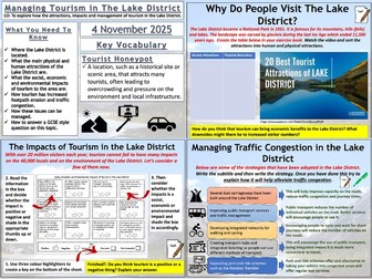
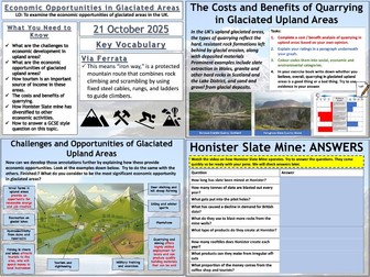
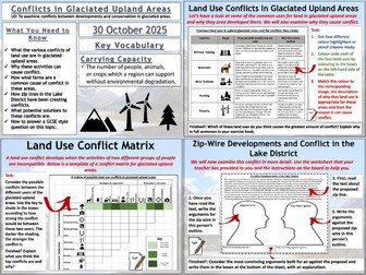
We start by looking at the a photograph that shows a variety of land uses in glaciated areas, notably a wind farm. Focusing on the wind farm the students annotate the photograph to explain why they can create conflict in these areas. Answers appear on the board if needed. As an example we look at wind turbines installed in the Kirkstone Pass (Lake District). We then look at some common land uses in glaciated upland areas and the students complete a colour coding exercise where they match the land use up to an image, a description and a reason why it can create conflict. As an extension activity the students can then complete a conflict matrix by shading the boxes on the matrix in according to how strong a conflict they perceive it to be. We then look at zip line proposals in the Lake District. The students have a sample of text to work with and they complete a worksheet to detail the arguments for and against the zip line development. We finish with a 6 mark GCSE-style exam question with guidance on how to answer it.
Hope this saves you some valuable planning time.
https://www.tes.com/teaching-resources/shop/markthegeographer
KS3 Topic - Glaciation
Lesson 1 - What are glaciers and where are they located?
Lesson 2 - How are glaciers formed and how can they shape the landscape?
Lesson 3 - Processes of Glaciation
Lesson 4 - Glacial landforms shaped by erosion.
Lesson 5 - Glacial landforms shaped by deposition
Lesson 6 - What is it like to live in a glacial environment?
Lesson 7 - Climate Change vs Glacial Environments
Fully resourced lessons with a wide range of activities.
Homework sheets and differentiated lower ability worksheets included.
Revision A3 sheet a d topic test also included.
AQA GCSE Geography lesson for the latest specification Unit 1B: In this lesson we look at transportation and depositional landforms such as moraines, drumlins and erratics.
The starter is glaciation-themed retrieval quiz.
We then look at the idea of the glacial conveyor belt, what glacial till is and what the difference between sorted and unsorted material is and why they form in different environments. The pupils create diagrams of both. We then consider moraines and the different types of moraines. The pupils have a diagram to annotate and label. We then consider drumlins, the pupils again create diagrams and learn why they show direction of movement and collective called ‘basket of eggs’ topography. We then briefly look at erratics and how they can also show the history of glacier movement. We finish with a 4 mark GCSE-style exam question with guidance on how to answer it.
Hope this saves you some valuable planning time.
https://www.tes.com/teaching-resources/shop/markthegeographer
AQA GCSE Geography lesson for the latest specification Unit 1B: In this lesson we look at the processes of weathering, erosion, transportation and deposition in glacial environments.
The starter is just a quick photo mystery around glacial deposits.
We then look at the extent of the ice sheet during the Last Glacial Maximum (LGM). We introduce freeze-thaw weathering as the principle type of weathering in glacial environments as the pupils create a sequential diagram. The pupils are provided with a diagram to annotate for the processes of abrasion and plucking. We watch a video on the transportation of material by the glacier and the pupils create a diagram. They then construct a paragraph on transportation by guessing the missing words using the picture prompts. They also construct a paragraph on deposition based on sentence fragments. We finish with a 4 mark GCSE-style exam question with guidance on how to answer it.
Hope this saves you some valuable planning time.
https://www.tes.com/teaching-resources/shop/markthegeographer
AQA GCSE Geography lesson for the latest specification Unit 1C: In this lesson we look at opportunities for ecomomic activities in glaciated upland areas of the UK.
There is a retrieval practice starter based upon prior learning in the section.
We start by looking at the challenges to economic activities in glaciated upland areas and the students annotate the diagram. Using the same diagram, the students then have to spot and label the economic activities that they can see. The students then develop those annotations further by explaining how these provide economic opportunities. We briefly look at tourism in these areas and the students complete a cloze exercise. We take a look at quarrying next and the students will watch a video on the Honister Slate mine, answering questions on a worksheet, before evaluating the costs and benefits of quarrying in these areas by creating a living graph. We finish with a 6 mark GCSE-style exam question with guidance on how to answer it.
Hope this saves you some valuable planning time.
https://www.tes.com/teaching-resources/shop/markthegeographer
This resource contains a word document with 5 model answers based on glaciation past paper questions, from AQA GCSE Geography. It also contains a PowerPoint which can be used to guide students through exam technique.
This comprehensive collection provides clear, detailed explanations of key glaciation landforms and processes. Each card covers essential features such as corries, arêtes, U-shaped valleys, drumlins, and more
This set of cards if completely customizable and can be edited to suit the needs of your students
AQA GCSE Geography lesson for the latest specification Unit 1C: In this lesson we look at tourism in the Lake District. The attractions, impacts of tourism and management.
There is a multiple choice retrieval practice starter based upon prior learning in the section.
We start by looking at the location of the Lake District. The students complete a cloze exercise to create a paragraph detailing the location using information from the board. We then look at the human and physical attractions of the Lake District. The students watch a short video and sort the attractions into a table. Students then consider the impacts of tourism to the area. They are provided a worksheet and asked to sort the statements into, firstly advantages and disadvantages, then social, economic or environmental impacts. We then look at traffic congestion and how it is managed. The students are presented with some possible solutions, but they must explain how these help to reduce congestion. We then watch two videos on footpath erosion and the students create a diagram on the causes and problems of footpath erosion and the solutions, with a focus on the organisation ‘Fix the Fells’ and their work on the fells. We finish with a 6 mark GCSE-style exam question with guidance on how to answer it.
Hope this saves you some valuable planning time.
https://www.tes.com/teaching-resources/shop/markthegeographer
Lesson 3 of 8.
Lesson Objectives:
To know the four main processes operating in a glacial valley.
To understand how specific processes such as plucking, freeze thaw and abrasion shape the landscape.
To be able to link glacial processes to explain the landscape they have left behind.
LA structured worksheet included
A wide range of glaciation resources. Detailed definitions and descriptions of landforms, processes and formations. Revision sheets, worksheets, powerpoints and case studies.
AQA GCSE Geography lesson for the latest specification Unit 1B: In this lesson we look at the types of erosional landforms you find in glaciated landscapes.
The starter is just a quick coast-themed retrieval practice quiz which has been left blank so you can add your own questions.
We start by looking at the erosive power of glaciers and how corries form in highland areas. The pupils create a sequential diagram to show how a corrie forms from small nivation hollows. We then look at aretes and pyramidal peaks with examples of each and then look at how erosion has created a variety of further highland erosional features when the pupils annotate a diagram of a highland glaciated area. We finish with a 6 mark GCSE-style exam question with guidance on how to answer it. The lesson also uses some video clips to help the pupils visualise these features.
Hope this saves you some valuable planning time.
https://www.tes.com/teaching-resources/shop/markthegeographer
This resource contains all the materials to teach a full unit titled Glaciation and Rivers. This is designed for year 7’s however could easily be edited to cater for slightly older year groups.
This resource contains all powerpoints, resources, homeworks and assessment materials. Lesson titles are as follows:
Lesson 1 - Glaciation
Lesson 2 - Glacial Processes
Lesson 3 - Erosional Landforms Part 1
Lesson 4 - Erosional Landforms Part 2
Lesson 5 - Transportational and Depositional Landforms
Lesson 6 - Using Glacial Landforms
Lesson 7 - Mid Unit Assessment
Lesson 8 - The Water Cycle
Lesson 9 - Drainage Basin
Lesson 10 - Fluvial Processes
Lesson 11 - Upper Course Landforms
Lesson 12 - Middle Course Landforms
Lesson 13 - Causes of Flooding
Lesson 14 - River Management
Lesson 15 - End of Unit Assessment
Plus 2 additional pieces of material:
Mid Unit Feedback
End of Unit Feedback
Lesson 2 of 8
Lesson Objectives:
Understand the stages of glacier formation.
Explain how glaciers form using geographical vocabulary and diagrams.
Recognise key features associated with glacial landscapes.
LA structured worksheet included
This knowledge booklet is used alongside the unit of work for KS3 Glaciation to provide the students with an overview of the lessons they will be doing and practice questions for them to have a go at and ideas of questions in the tests.