docx, 3.14 MB
docx, 3.14 MB
pptx, 5.98 MB
pptx, 5.98 MB

Students will be able to describe where the UK is located globally using a variety of descriptors such as; longitude and latitude, recapping of the continents and surrounding seas and oceans. Student should also be able to describe the countries that make up the UK, British Isles and GB. Finally students will learn the difference between weather and climate and then asked to describe the climate of the UK in Winter and Summer.

Starter: Knowledge Retention - Recapping on previous learning
Task 1: Describe the importance on why describing a place accurately is important.
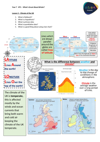
Task 2: How to read longitude and latitude, then describe the UK’s longitude and latitude.
Task 3: Recap on the continents and oceans.
Task 4: What is the difference between weather and climate, and what is the UKs climate zone.
Task 5: Main Task: Describe the UK’s temperature in Summer and in Winter.
Task 6: Plenary: Home learning of an A3 poster of several physical features in the UK.

Lesson contains one powerpoint and one worksheet.

Get this resource as part of a bundle and save up to 40%

A bundle is a package of resources grouped together to teach a particular topic, or a series of lessons, in one place.

Bundle

Features of the UK and Fieldwork - KS3 (Key Stage 3)

An introductory topic for KS3 geography this bundle is great for Year 7 in their first term at school. This gets students familiar with geographical concepts of fieldwork, data, human and physical geography. This bundle contains 7 lessons that are fully resourced, with powerpoints and worksheets. Throughout the series of lessons, students will firstly conduct fieldwork investigation into the environment of their school to get them engaged in geography and explain why it is important along with data collection and presentation. Then students will investigate the location of the UK, this is done to provide a strong basis for all students regardless of primary school. This includes continents, countries, seas and the use of longitude and latitude. Students will then learn about the climate and weather of the UK, the case study of the River Severn along with its basic features of a river and the Holderness Coast along with headlands and bays and a quick introduction of geology. Then students will investigate human geography and its features of human settlements and scales along with identifying major UK cities and the density/sparseness. Finally students end on the case study of Leeds and its importance as a UK city. Lesson 1: Introduction to Fieldwork Lesson 2: Data and Fieldwork Lesson 3: Climate of the UK Lesson 4: Rivers of the UK Lesson 5: Coasts of the UK Lesson 6: Cities of the UK Lesson 7: Importance of Leeds Students will gain a variety of skills such as fieldwork, data collection and manipulation along with manipulation. Along with OS map reading and bar chart analysis This bundle contains fully resourced lessons along with worksheets.

£8.40

Reviews

Something went wrong, please try again later.

This resource hasn't been reviewed yet

To ensure quality for our reviews, only customers who have purchased this resource can review it

Report this resourceto let us know if it violates our terms and conditions.
Our customer service team will review your report and will be in touch.