
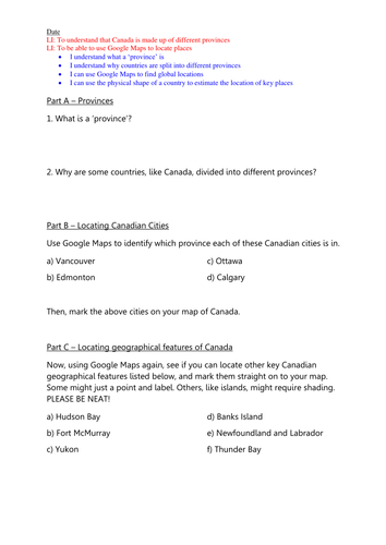
This lesson activity developed two learning objectives: 1) To understand that Canada is made up of different provinces and 2) To be able to use Google Maps to locate places.
My class studied the human and physical geographical features of Canada as part of their cross-curricular topic work (mainly focusing on rivers and mountains) therefore I wanted them to get to know the geography of Canada itself more, especially because it is so diverse. Therefore I made this activity which required children to:
• Understand what a ‘province’ is
• Understand why countries like Canada are split into different provinces
• Use Google Maps to find global locations
• Use the physical shape of a country to estimate the location of key places
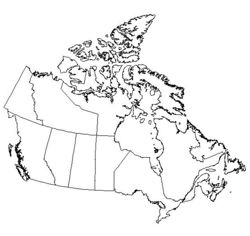
They then used the internet to research information about provinces, and then to locate key provinces, cities, and physical geographical features (e.g. Hudson Bay), marking them as accurately as possible on to their own blank map. I have included one blank map example, but others are readily available on Google images.
My class studied the human and physical geographical features of Canada as part of their cross-curricular topic work (mainly focusing on rivers and mountains) therefore I wanted them to get to know the geography of Canada itself more, especially because it is so diverse. Therefore I made this activity which required children to:
• Understand what a ‘province’ is
• Understand why countries like Canada are split into different provinces
• Use Google Maps to find global locations
• Use the physical shape of a country to estimate the location of key places
They then used the internet to research information about provinces, and then to locate key provinces, cities, and physical geographical features (e.g. Hudson Bay), marking them as accurately as possible on to their own blank map. I have included one blank map example, but others are readily available on Google images.
Something went wrong, please try again later.
This resource hasn't been reviewed yet
To ensure quality for our reviews, only customers who have purchased this resource can review it
Report this resourceto let us know if it violates our terms and conditions.
Our customer service team will review your report and will be in touch.
£2.00