
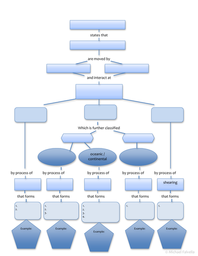
This is a mind map to help students make connections between various types of plate boundaries and the processes involved that created various landforms. I use this for my AS (CIE Cambridge curriculum) geography students for the rocks & weathering unit but it could also be used as a refresher activity for A2 students who are learning about hazardous environments. It could be used as a revision tool or be used for a homework assignment or even a quiz. Student answer sheet, word bank and answer key (3 pages) are included in this document. The cover image is only a partial view of the blank student answer sheet (1st page).
This exercise satisfies most of the following learning objectives:
- Understand the different types of plate boundaries, why they occur and the processes that operate there: divergent (constructive), conservative, convergent (destructive)
- Understand processes such as subduction and sea floor spreading
- Describe and explain the landforms formed at boundaries, such as: fold mountains, ocean ridges, rift valleys, ocean trenches, volcanic island arcs, accretionary wedges
Something went wrong, please try again later.
This resource hasn't been reviewed yet
To ensure quality for our reviews, only customers who have purchased this resource can review it
Report this resourceto let us know if it violates our terms and conditions.
Our customer service team will review your report and will be in touch.
£2.00