Investigating Rivers is a Geography unit suitable for KS2 (Y4-6).
The planning overview and topic title page can be downloaded for free here. Lessons include:
L1 - Understanding the water cycle
L2 - Identifying features of a river system
L3 - Identifying characteristics of the three stages of a river
L4 - Investigating features of the River Thames
L5 - Thinking about the different ways we use water
L6 - Understanding the impacts of floods and droughts
Each lesson includes a presentation and differentiated activities/worksheets.
If you like this resource, we would appreciate a review! We will happily send you a free resource in return for a review or useful suggestions/feedback. Contact us at ed@teachitforward.co.uk.
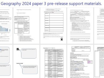
AQA GCSE Geography paper 3 pre-release support for 2024.
Tudeley Village development.
This document contains 12 pages of resources that can be set as homework to run along the pre-release booklet or taught in class.
Includes:
Exemplar answer to a question that could possibly be similar to the 9 mark question this summer. Last year’s prediction was correct as well as for 2022.
Task sheet to help student to examine the pre-release booklet.
Additional suggested questions to practice.
Now updated due to the change in the map provided by AQA.
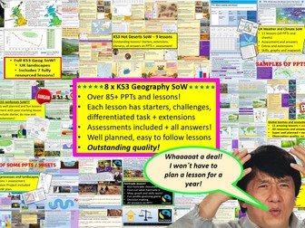
GET ALL OF MY PAID KS3 RESOURCES FOR JUST £13.99!!!
85+ lessons for under £14 or less than 15p a lesson… Bargain!
**Eight Key Stage 3 Schemes of work, enough teaching content for almost two years! **
All of my lessons are well planned, engaging, differentiated and fun! Download one of my free ones if you aren´t sure and try before you buy!
The following 8 Schemes of work are included WITH assessments:
World biomes (11 lessons)
• Lesson 1: Ecosystems
• Lesson 2: Food webs
• Lesson 3: Global biomes introduction
• Lesson 4: Mediterranean biome
• Lesson 5: Coral Reefs
• Lesson 6: Bamboo forests
• Lesson 7: Tropical Rainforests
• Lesson 8: Hot deserts
• Lesson 9: Polar biomes
• Lesson 10: Assessment lesson
• Lesson 11: Peer feedback/marking lesson
River landscapes of the UK (7 lessons)
• Lesson 1: Where are the UK’s rivers?
• Lesson 2: What are the UK’s rivers like?
• Lesson 3: What processes happen inside a river?
• Lesson 4: How do waterfalls form?
• Lesson 5: Meanders… they’re forever changing
• Lesson 6: The Landforms of the Lower Course
• Lesson 7: The Somerset levels floods 2014
• Lesson 8: How can we our manage rivers?
• Lesson 9: Rivers Assessment lesson
Weather and climate of the UK (9 lessons)
• Lesson 1: What is weather and climate?
• Lesson 2: Recording the Weather
• Lesson 3: Who cares about the weather?
• Lesson 4: Where does the UK’s weather come from?
• Lesson 5: The Beast from the East
• Lesson 6: How can the UK use it’s wind?
• Lesson 7: Does the UK need so much rain?
• Lesson 8: What are Urban Micro climates and how do they affect London?
• Lesson 9: Assessment and feedback
Tropical Rainforests (12 lessons)
• Lesson 1: What and where are our rainforests?
• Lesson 2: What is the structure of the Rainforests?
• Lesson 3: What is the climate like in the Rainforest?
• Lesson 4: How are plants and animals adapted to the rainforest?
• Lesson 5: How do we benefit from the Rainforest?
• Lesson 6: What is Deforestation?
• Lesson 7: What are the effects of Deforestation?
• Lesson 8: How can we use the rainforest sustainably?
• Lesson 9: Saving the Rainforest!
• Lesson 10: Assessment lesson
• Lesson 11: Assessment feedback and peer marking lesson.
• Lesson 12: Extended project: Researching a rainforest.
UK landscapes and processes (7 lessons)
• Lesson 1: introduction to UK landscapes
• Lesson 2: How does geology shape the UK?
• Lesson 3: Chemical weathering and limestone plateaus
• Lesson 4: Mountains in the UK: Their birth and erosion
• Lesson 5: Forests in the UK
• Lesson 6: Map reading and tourist developments in the lake district.
• Lesson 7: Assessment lesson with feedback PPT.
Polar biomes & environments (11 lessons)
Lesson 1 - Polar Environments, what are they and where they
Lesson 2 - Polar biomes climate graph
Lesson 3 - How have some plants and animals adapted to live in The Arctic
Lesson 4 - The threats to Polar biomes
Lesson 5 - How fast are polar biomes warming
Lesson 6 - Tourism in polar biomes
Lesson 7 - The Antarctic treaty
Lesson 8 - Should we mine Antartica
Lesson 9 - Map reading in Polar biomes
Lesson 10 - Assessment lesson
Lesson 11 - Assessment feedback & peer marking
Hot deserts (9 lessons)
Lesson 1: What is a hot desert and where are they found?
Lesson 2: Drawing a climate graph for hot deserts
Lesson 3: How can animals and plants survive in hot deserts?
Lesson 4: What is desertification and why is it happening?
Lesson 5: Can desertification be stopped?
Lesson 6: Tourism in a hot desert far far away…
Lesson 7: Can you navigate through a hot desert?
Lesson 8: Assessment lesson
Lesson 9: Peer marking and assessment feedback
Globalisation 12 lessons
Lesson 1: An introduction to globalisation
Lesson 2: How has globalisation happned?
Lesson 3: Why do companies go global? Mcdonalds
Lesson 4: What is a TNC and why do they work in so many countries?
Lesson 5: The pros and cons of globalisation
Lesson 6: The dark side of globalisation
Lesson 7: A TNC in Nigeria: Shell
Lesson 8: How is globalisation helpful? NGOs
Lesson 9: IGOs: WHO will stop Malaria?
Lesson 10: Assessment lesson
Lesson 11: Peer marking and assessment feedback
Lesson 12: Optional project on a TNC
Interplanetary population project
extras (wordsearches, extensions, games mapping, Halloween mapping…)
This includes ALL of my lessons, quizzes, and six full schemes of work with over 75 lessons in total!!!
(some stand alone lessons are omitted as they are repeated/included in SoW)
Please check out all of my FREE school resources and Geography lessons on my shop where you´ll also find full schemes of work for just £3 and lots of other useful resources����� Or purchase all of my KS3 resources for just £13.99!
I would really appreciate it if you could leave me a review, thanks!
https://www.tes.com/teaching-resources/shop/ukjoshkelly94
Questions or issues: ukjoshkelly@yahoo.co.uk
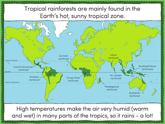
This lesson is part of Tropical Rainforests, a Geography unit designed for students in KS2, but can also be taught as a stand alone lesson. All resources are compatible with both Microsoft Office and Google Workspace.
The presentation introduces students to tropical rainforests, including some of the flora and fauna that live in them. Students then learn about the Earth’s tropical belt and the location of the various rainforests within it.
The activity challenges students to label features of a world map including the Equator, the Tropic of Cancer and the Tropic of Capricorn. Students then locate 8 of the world’s tropical rainforests.
Easier - Students use a prompt map and have activity clues.
Harder - Students use a prompt map but have no activity clues.
Extension - Students fill in the missing words in a paragraph about tropical rainforests.
If you like this resource, we would appreciate a review! We will happily send you a free resource in return for a review or useful suggestions/feedback. Contact us at ed@teachitforward.co.uk.
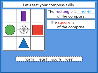
This lesson is an ideal introduction to compass directions for younger children.
It is part of Our World, a Geography unit designed for students in KS1 and lower KS2 (Y1-3), but can also be taught as a stand alone lesson.
The presentation introduces the four cardinal points of the compass (North, East, South and West). It then challenges students to describe the position of objects using these compass directions.
The activity worksheets are differentiated two ways:
Easier – Students describe the position of objects using compass directions (simple questions).
Harder – Students describe the position of objects using compass directions (mixed questions).
Extension – Students fill in the blanks on a compass using different vocabulary.
If you like this resource, we would appreciate a review! We will happily send you a free resource in return for a review or useful suggestions/feedback. Contact us at ed@teachitforward.co.uk.
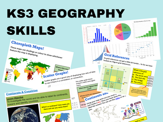
Full unit of work for map and graph skills. All lessons are fully resourced. Lessons are designed to last for 50-60 minutes. Lessons are resourced with videos, extension questioning, deep thinking and uses graphs/images to aid learning.
These lessons follow the Oxford KS3 curriculum and look at;
Continents & Countries
Map Skills
Directions
Distance & Scale
Grid References
Longitude & Latitude
Height
OS Symbols
Graph Skills
Each lesson includes a starter, lesson objective, plenary and various student led activities.
If you liked this resource please check out my other resources at https://www.tes.com/teaching-resources/shop/SimpleGeography
A simple coloured world map with coordinates. Children can use the map to become familiar with countries, continents, oceans and seas! Also using their coordinates skills. Can be printed A4/A3 depending on use.
Mountain Environments is a Geography unit suitable for KS2 (Y4-6) and has everything you need for covering a mountains topic.
The planning overview, topic title page and vocabulary page can be downloaded for free here. Lessons include:
L1 – Identifying the key features of mountains
L2 – Identifying the world’s major mountain ranges
L3 – Locating the world’s famous mountains using latitude and longitude
L4 – Understanding how fold mountains are formed
L5 – Investigating the structure of a volcano (FREE)
L6 – Researching famous world mountains (FREE)
L7 – Investigating mountain climates
Each lesson includes a presentation and differentiated activities/worksheets.
If you like this resource, we would appreciate a review! We will happily send you a free resource in return for a review or useful suggestions/feedback. Contact us at ed@teachitforward.co.uk.
Unlock the world map’s secrets with this engaging KS2 geography lesson on latitude and longitude! Perfect for Years 3-6, this comprehensive resource has everything you need to deliver an outstanding lesson that will leave a lasting impression on your students and even Ofsted inspectors.
What’s Included:
★ Interactive PowerPoint: Captivating visuals and clear explanations bring the concepts of latitude, longitude, the Equator, and the Tropics to life.
★ Engaging Worksheets: Hands-on activities, including labeling maps and creating sentences about countries’ locations, reinforce learning and assess understanding.
★ Detailed Lesson Plan: A step-by-step guide with clear objectives, differentiated tasks, and extension activities to cater to all learners.
★ Fun & Memorable Video Song: Help students remember the difference between latitude and longitude with a catchy tune.
★ WAGOLL Example & Sentence Starters: Provide support and scaffolding for students, especially those needing extra help.
★ All Resources Included: Everything you need to teach this lesson is provided, including a starter task, world map activity, writing task, success criteria strip, word bank, and more.
Key Learning Outcomes:
★ Differentiate between weather and climate.
★ Label and understand the significance of latitude, longitude, the Equator, and the Tropics.
★ Explain the purpose and direction of these lines.
★ Use latitude and longitude to describe the location of countries.
Why Choose This Resource?
★ Ofsted-Approved: Successfully used for a lesson observation, demonstrating its effectiveness in meeting high teaching standards.
★ Curriculum-Aligned: Covers key KS2 geography objectives related to locational knowledge and map skills.
★ Engaging & Interactive: Includes a variety of activities and a fun video song to keep students motivated and involved.
★ Differentiated: Caters to different learning styles and abilities, ensuring all students can succeed.
★ Ready-to-Use: Save valuable prep time with all materials provided in a clear and organized format.
Empower your students to navigate the world with confidence!
Ideal for: KS2 Geography, Years 3-6, latitude and longitude, map skills, weather and climate, hemispheres, Earth’s grid, NQT, ECT interview lessons.
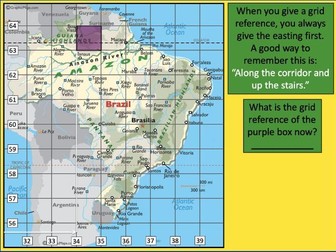
This lesson is part of Exploring Brazil, a Geography unit designed for students in KS2 (Y4-6), but can also be taught as a stand alone lesson.
It is a great introduction to using 6-figure grid references. The presentation first recaps how to find 4-figure grid references, then demonstrates how to find 6-figure grid references step by step.
There are two activities:
Activity 1:
Students locate 16 Brazilian cities using 4-figure grid references.
Extension – Students answer questions involving grid references and compass directions.
Activity 2:
Students have a go at describing the location of Brazilian cities more precisely using 6-figure grid references.
Easier – Students use mini-grids to help them locate 16 cities using 6-figure grid references.
Medium – Students use mini-grids to locate 8 cities, then estimate 6-figure grid references for 8 more cities.
Harder – Students have to estimate 6-figure grid references for all 16 cities (i.e. no mini-grids).
If you like this resource, we would appreciate a review! We will happily send you a free resource in return for a review or useful suggestions/feedback. Contact us at ed@teachitforward.co.uk.
This lesson is designed for KS2 children. It can be taught as a stand alone lesson but is also available as part of two wider units, both of which are available on TES:
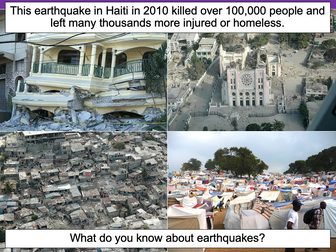
-Earthquakes
-Volcanoes & Earthquakes
First the presentation looks at how the Earth’s crust is split into tectonic plates. It then examines the causes of earthquakes, how they occur at the fault lines between tectonic plates and what the hypocentre and epicentre of an earthquake are.
There are three different activities to choose from which can be done in Geography and/or Literacy lessons. These include:
Quiz Activity
Students watch a video clip about earthquakes and answer comprehension questions about it. This is differentiated two ways.
Cloze Procedure Activity
Students fill in the blanks in an explanation text about earthquakes. This is differentiated two ways.
Writing Activity
Student write an explanation text about earthquakes. This is differentiated three ways and comes with vocabulary and sentence starter prompts.
If you like this resource, we would appreciate a review! We will happily send you a free resource in return for a review or useful suggestions/feedback. Contact us at ed@teachitforward.co.uk.
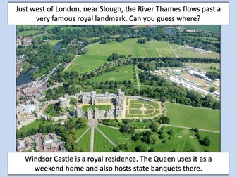
This lesson is part of Investigating Rivers, a unit designed for upper KS2 (Y4-6).
The presentation takes students on a journey from the source to the mouth of the River Thames. Starting at Thames Head, the source of the River Thames, students investigate maps and satellite photos and try to identify river features along the way. Other locations include Windsor Castle, the Isle of Dogs in London and the mouth of the river at Southend-on-Sea.
The writing-based activity challenges students to first label each map/satellite photo and then write a paragraph describing the location and river features they can see. It is differentiated two ways:
Easier – Students have maps/satellite photos and cloze procedure paragraphs to complete.
Harder – Students have maps/satellite photos, a wordbank and write their own paragraphs.
If you like this resource, we would appreciate a review! We will happily send you a free resource in return for a review or useful suggestions/feedback. Contact us at ed@teachitforward.co.uk.
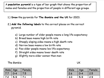
Activity for pupils to draw and compare population pyramids for The Gambia and The UK, using 2023 data. There is a outline set of axes with an example plot on it for lower ability pupils and a labelling activity to pupils to demonstrate their ability to interpret the graphs. In addition there is a visual hexagons task which asks pupils to explain various factors and their influence on population size and structure which would make a good homework task.
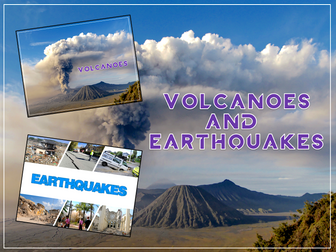
Volcanoes & Earthquakes is an exciting extended Geography unit designed for students in KS2.
The planning overview, topic title page and vocabulary page can be downloaded for free here. Lessons include:
L1 – Understanding the structure of the Earth
L2 – Investigating the structure of a volcano (FREE)
L3 – Locating the world’s famous volcanoes
L4 – Investigating the five deadly features of a volcanic eruption
L5 – Understanding tectonic plates
L6 – Exploring the effects of volcanic eruptions on Montserrat
L7 – Why do people live near volcanoes?
L8 – Understanding the causes of earthquakes
L9 – Investigating the five deadly features of an earthquake
L10 – Researching earthquakes using Wikipedia
L11 – Locating the world’s biggest earthquakes using latitude & longitude
L12 – Writing a fact file about a famous earthquake
Each lesson includes a presentation and differentiated activities/worksheets.
A FREE newspaper report template is also included in this unit.
If you like this resource, we would appreciate a review! We will happily send you a free resource in return for a review or useful suggestions/feedback. Contact us at ed@teachitforward.co.uk.
Immerse your KS2 students in the pivotal events of World War I with this comprehensive and engaging history unit! Meticulously crafted for Years 3-6, this resource provides everything you need to deliver outstanding lessons that spark curiosity, develop historical skills, and foster a deep understanding of the Great War’s impact.
What’s Inside:
★ 12 Detailed Lesson Plans: Step-by-step guidance for each lesson, including clear learning objectives, stimulating activities, and differentiation strategies to cater to all learners.
★ Engaging PowerPoint Presentations: Bring history to life with visually rich slides featuring historical photos, maps, and thought-provoking questions.
★ Diverse Resources: A wealth of printable resources, including timelines, propaganda posters, trench diagrams, poetry analysis worksheets, and more.
★ Creative Activities: Encourage students to express their understanding through creative projects like designing propaganda posters and writing their own WWI poems.
Key Learning Outcomes:
★ Causes & Consequences: Students will understand the complex causes of World War I and its profound impact on the world.
★ Life in the Trenches: Gain a vivid insight into the harsh realities of trench warfare and the daily lives of soldiers.
★ Home Front: Explore how the war affected people on the home front, including rationing, women’s roles, and the impact on children.
★ Propaganda & Communication: Analyze the role of propaganda and communication in shaping public opinion during the war.
★ Remembrance & Legacy: Reflect on the significance of Remembrance Day and the lasting legacy of World War I.
Why Choose This Resource?
★ Curriculum-Aligned: Meets the national curriculum objectives for KS2 History.
★ Outstanding Quality: Expertly designed to engage and challenge learners, fostering a deep understanding of historical events.
★ Ready-to-Use: Save valuable prep time with all materials provided in a clear and organized format.
★ Cross-Curricular Links: Explore connections to geography, English, and art, enriching the learning experience.
Inspire a lifelong love of history with this exceptional World War I unit!
Ideal for: KS2 History, Year 3, Year 4, Year 5, Year 6, World War 1, WW1, the Great War, trench warfare, propaganda, remembrance, British history, European history.
The lesson is aimed at KS3 students, but could also be adapted for Upper Primary. The lesson objective is to develop students' knowledge of OS map symbols and allows students to practice using OS symbols to create maps of their own.
The lesson begins with a 'Do Now Task' in which students work in differentiated groups to compare a variety of different map types. Each group is given a slightly more complex question depending on their ability. Groups then present their answers to the rest of the class.
Students then attempt to guess the learning outcomes through viewing a cartoon, before beginning two mapping tasks. The first map task is a timed challenge in which groups must identify as many OS symbols as they can in 5 minutes using an OS Legend and a map. The second task involves creating a map of their own through converting a map which has all the features written in text, into a map which shows all these features using their correct symbol. The lesson also develops knowledge of several keywords/features (e.g. embankment and cutting).
Latitude and Longitude worksheet asking to students to label the main lines of latitude and longitude across the globe. Sheet also contains extension questions which increase in difficulty.
A map skills homework booklet for use with KS3 Geography classes.
An amalgamation of worksheets I have gathered over the years to create a comprehensive and easy to mark Map Skills Homework Booklet!
Assessing compass directions, measuring distance, grid references, map symbols, contour lines and describing directions, this workbook is a great revision tool for geographers of any age wanting to hone their OS map skills.
 Quick View