
103Uploads
140k+Views
52k+Downloads
Geography
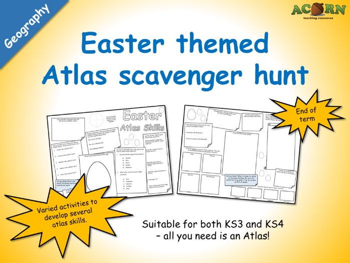
Geography - Easter Atlas Skills (scavenger hunt activity sheet)
Geography - Easter Atlas Skills (scavenger hunt activity sheet)
A double sided worksheet intended to use with pairs and small groups - all they need is an Atlas or two. Teacher notes are included with some suggestions. Basically, they are required to use an Atlas in several ways to find out a range of information (some of which is linked to Easter). There are a few other activities on the sheet (such as design an Easter egg).
Great for end of term activities, and will work with KS3 and KS4 students.
All reviews for our premium products have been 5/5* (As of February 21st 2017).

Geography - Coasts - Erosion - Coastal Landforms
Three labelled PPT diagrams to include in a lesson, to help when teaching...
- Cliffs and wave cut platforms
- Caves, arches, stacks and stumps
- Headlands and bays
Three worksheets to help students learn or demonstrate understanding. The worksheets have several tasks to help the students complete the diagram and link it to the processes of erosion.
As of the 20th January, every single review we've had for a premium resource has been 5/5*
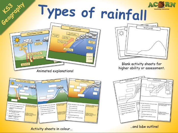
Types of rainfall (animations and activity sheets)
Types of rainfall (animations and activity sheets)
These are lesson elements intended to be used in the teaching of weather/climate and types of rainfall.
- Three colourful animations to introduce / teach convectional, frontal and relief rainfall.
- Three activity sheets with diagrams / written work.
- Three outline activity sheets which can be used with higher ability students, or to assess.
All reviews for our premium resources have been 5/5 (As of February 20th 2017)
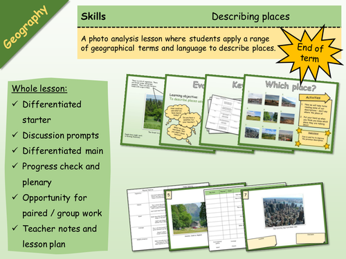
Geography - Skills - Describing Places
A big lesson with lots of opportunity for differentiation and engagement, as well as paired or group work.
Basically, students learn how to describe places, and then apply this skill. It would work well as a skills building lesson in KS3, or as an end of term type lesson with either KS3 or KS4.
There are differentiated resources for lower and higher, and a number of ways in which the activities could be undertaken (which are in the lesson plan). There are teacher notes and a lesson plan. The activities are clear, and there are Superstar extension activities.
---
The main aim is…
This is a big lesson which could be used as an end of term activity, or as a skills building lesson.
Students either learn or develop their geographical terminology and then apply / demonstrate using photos of actual places.
Key ideas and content…
We can describe places using geographical language.
It is more effective to use the correct key terms and descriptive language.
To differentiate…
Pass the sheets round on a timer, with the challenge of either adding more key terms or improving existing ones.
Stick the sheets on the wall around the room, give each student a different key term to look for. Students go round the room.
Insist on certain terms being applied.
To extend…
Insist on a description of features which aren’t necessarily visible.
Students find their own photos and analyse them.
Peer assessment.
There are some tricky terms in the key terms activity, use to stretch students.
To assess…
Discussion points.
The work produced.
Peer assessment opportunity.
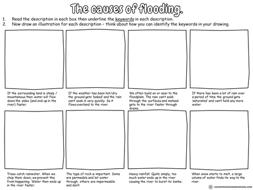
Geography - the causes of flooding worksheet
A simple activity to be included with teaching about the causes of flooding.
Students read the descriptions and draw a diagram for each one.
Ideal for lower ability groups.
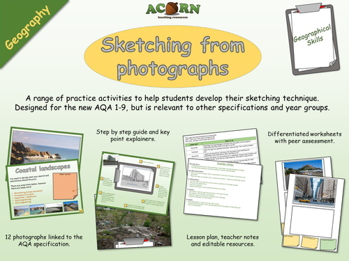
Geography - Geographical skills - Sketching (field and from photos)
A range of practice activities to help students develop their sketching technique. Designed for the new AQA 1-9, but is relevant to other specifications and year groups.
The lesson would be particularly useful to a GCSE group before they do their fieldwork, and will also be suitable for a KS3 class.
There are also detailed 'key points' so students understand why they need to know how to sketch, and what technique makes it effective. On top of the field sketching there is a focus on application of key terms.
The lesson has a range of visual resources, all relevant to the new 1-9 GCSE.
A free wallchart is available to download at https://www.tes.com/teaching-resource/geography-geographical-skills-sketching-wall-display-11486949
The main aim is…
To develop and practice field sketching / sketching from photographs technique.
To effectively annotate and label sketches to show understanding.
Key ideas and content…
This is a practical lesson which would benefit from lots of student interaction and discussion.
There are links to content, but it would work without – solely as a sketching lesson.
To differentiate…
Use the resources with the picture above a blank box for weaker groups.
Focus on the same photos.
Print the checklist.
Display the photos on the board and discuss as a class.
To extend…
This lesson could be used several times in the same format.
The teacher can add their own photos.
Take the class on a local visit to practice the technique.
Provide word banks for annotations.
To assess…
Peer assessment is woven into the main activity.
Teacher should be able to see visual progress with the quality of sketching and level of annotations.
All reviews for our premium resources have been 5/5 (as of 17th January 2017)
www.acornteachingresources.com
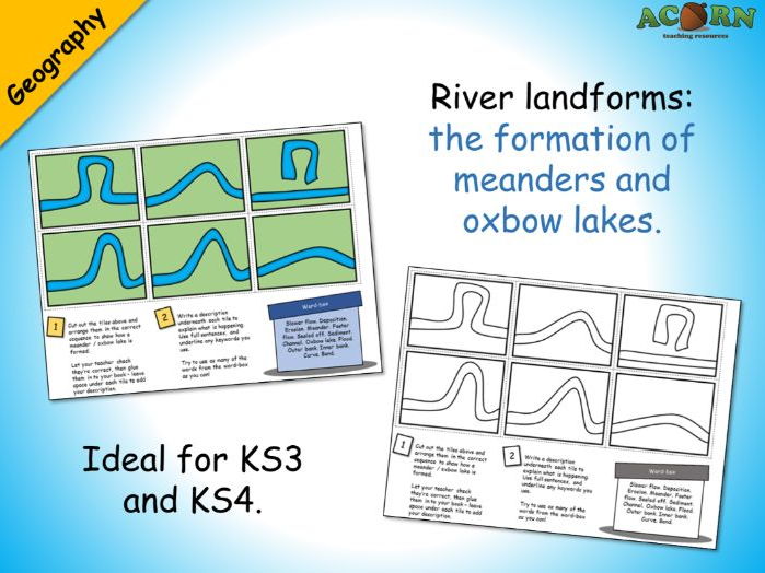
Geography - Meanders and oxbow lakes activity
Ideal for KS3 and KS4. Could be used to teach or consolidate.
Six tiles are jumbled up on the sheet - the students need to cut these out and arrange them in the correct sequence. The next task is to write a description underneath each tile - there is a word-box to help the students explain each stage. Prior knowledge / understanding will be needed to complete.
Could be used as a mystery – see if students can work out why the oxbow lake formed before you explain.
Two version are included; one in colour and one in outline black & white.
Every review we've had for a premium resource has been 5/5* (As of February 21st 2017)

Geography - Map skills - Direction
Geography - Map skills - Direction
A complete lesson with a range of activities and resources aimed at teaching students how to use direction as a geographical skill. Students will apply the skill in several different ways as well as develop their spatial understanding of Europe.
Complete lesson > thoroughly resourced and ready to teach > snappy starter > explainers > SPaG activity > practise questions > varied map activities > peer assessment > summary activity > teacher notes > lesson plan > lesson evaluation > homework
The main aim is…
For students to learn / apply skills in describing direction.
To develop a spatial understanding of Europe.
Key ideas and content…
There are 8 points to the compass (as far as we’re concerned for today anyway)
We use direction to describe location / journeying.
Direction can be used by many different people in different situations.
To differentiate…
Students could take turns doing the countries / cities activities and then swap to help each other.
One student in a pair could have the map or atlas and act as an expert.
Pair up students when doing the map work.
To extend…
Use an OS map of the local area, Google Earth, an Atlas or online mapping to explore places.
Use the homework template and a local map / online mapping to explore geographical features in the local area (using direction obviously).
Certainly use the CYO task and encourage students to think about how they can test understanding / get students to apply map skills beyond simply describing.
To assess…
The road trip / CYO activity is the main assessment point.
Class discussion and the summary activity will also show progress and allow you to assess understanding.
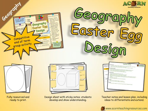
Geography - Design an Easter Egg (with a geographical theme)
End of term group activity to design an Easter egg with a geographical theme.
Will work as one lesson (with only the design proposal sheet completed) or two lessons (with completed designs on the templates).
Competitive element.
The group worksheet also has a 'Things we now know' to show progress'.
The teams have to work together to research and design an Easter egg with a geographical theme, this could be a place, landmark or something they've learned in lesson (more options given in lesson).
All resources are included. There is a pin board style slide to leave on the screen.
Laptops and atlases aren't essential, but will certainly help with the research (one per group).
www.acornteachingresources.com
All reviews for our paid products have been 5/5 (As of January 15th 2017).

River landforms - waterfall sequencing
Sequencing activity: River landforms - waterfalls
This is suited to KS3 but does work with KS4 - you'll need to add more detail (processes of erosion etc.).
There are four slides to help the teacher explain the processes involved and introduce the keywords.
The activity sheet requires students to complete three activities.
1. Cut out and arrange the tiles.
2. Add the labels from the sheet.
3. Add the descriptions from the sheet.
There is also an animated consolidation slide to allow teacher/students to check accuracy.
For higher ability - ask the students to underline the key terms, add more key terms and write their own descriptions.
Two version of the sheet are included; one in colour and one in outline black & white.
Every review we've received for a premium resource has been 5/5* (As of February 20th 2017)

Geography - Map skills - The Island - Assessment
Whole lesson / assessment - could be used to teach map skills or use as a stand alone assessment to use at the end of a map skills topic.
The assessment requires students to read a list of instructions and complete a map of 'The Island'. Students can show and develop their skills with grid references, distance, direction and map symbols.
The assessment element will show the teacher and student progress made, and also inform the student as to what they need to do to get to the next level.
There is an extra activity which then allows students to show their understanding about human and physical features, this could also make a good link to a tourism topic and incorporates literacy. Teacher notes and a brief lesson plan included with extension and differentiation notes.
This whole lesson is ready to go. All of our paid resources have received a 5/5* review as of 29th January 2017.
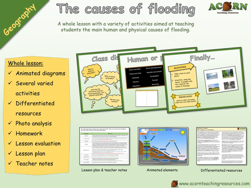
Geography - The causes of flooding - Whole lesson
Whole lesson - Geography - The causes of flooding
All reviews for our paid products have been 5/5 (As of January 5th 2017).
www.acornteachingresources.com
A whole lesson aimed at teaching students the main human and physical causes of flooding. Designed to be adaptable for KS3 and KS3, this lesson has a variety of differentiated activities and resources.
The main aim is…
For students to understand and explain the causes of flooding.
To differentiate between human and physical causes of flooding.
To link the causes to the processes of the river basin system – application of the key terms.
A secondary aim is for students to become familiar with the river basin system.
Key ideas and content…
There are both human and physical causes of flooding.
Events can happen in unique circumstances and in sequence to make flooding more likely.
Lesson includes:
Animated diagrams
Several varied activities
Differentiated resources
Photo analysis
Homework
Lesson evaluation
Lesson plan
Teacher notes

Measuring hurricanes
A range of activities with the aim of teaching students about the Saffir-Simpson hurricane wind scale.
Visually attractive, differentiated and fully resourced for a range of abilities.
Whole lesson: snappy starter, varied activities, key points, class discussion, assessment opportunities, a homework task and lesson evaluation. All resources included, along with lesson plan and teacher notes. This lesson has planned activities which show the teacher and the students their progress throughout.

Urban issues and challenges - Factors affecting the rate of urbanisation
AQA Geography
Urban issues and challenges - Factors affecting the rate of urbanisation
A whole lesson (possibly a double) which teaches students how rural-urban migration, and natural increase, is driving rapid urbanisation in LIC’s and NEE’s.
There are a range of activities, and varied resources to aid in the teaching. A visual explainer has been included. All resources are ready to go.
Whole lesson > Key concept starter > Discussion prompts > Key ideas > Card sort > Photo analysis > Exam style questions > Class discussion > Learning evaluation > Summary activity > Homework > Lesson plan > Teacher notes > Fully resourced > Visually attractive and ready to teach!
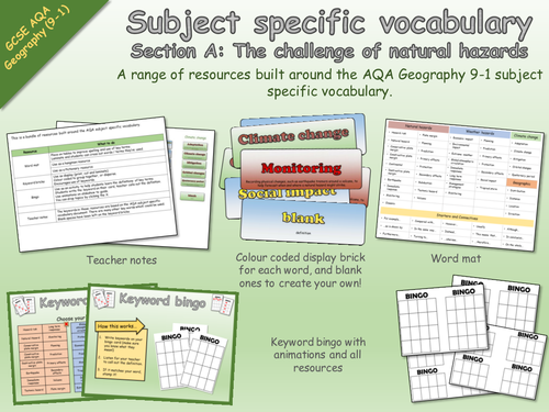
AQA Geography 9-1 Subject Specific Vocabulary - The challenge of natural hazards - Resources
Subject specific vocabulary resources
Section A: The challenge of natural hazards
A range of resources built around the AQA 9-1 Geography SSV for section A - The challenge of natural hazards.
Includes
- keyword bricks for display
- bingo game
- word mat
- teacher notes
All resources are included and are ready to print.
Keywords are grouped and colour coded.
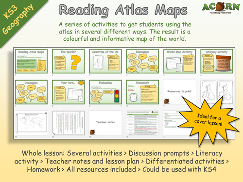
Geography - Reading Atlas Maps
*Requires an Atlas*
Originally aimed at KS3 but can be used with KS4. Ideal for cover, and getting to know groups. Gives lots of opportunity to talk about physical and human features around the world.
A series of activities to get students using the atlas in several different ways. The result is a colourful and informative map of the world.
Whole lesson: Several activities > Discussion prompts > Literacy activity > Teacher notes and lesson plan > Differentiated activities > Homework > All resources included > Could be used with KS4
The main aim is…
For students to use the atlas in several different ways to efficiently find information.
To complete a colourful and informative map of the world.
Every review we've had for a premium resource has been 5/5 (as of 2nd February 2017)
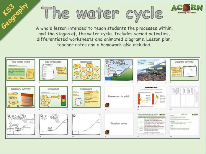
Geography - The Water Cycle
A whole lesson intended to teach students the processes within, and the stages of, the water cycle. Includes varied activities, differentiated worksheets and animated diagrams. Lesson plan, teacher notes and a homework also included.
The main aim is…
To understand the processes of the water cycle
To understand where and why these processes are taking place
To understand the sequence / stages of the water cycle
Key ideas and content…
Evaporation, transpiration, condensation, precipitation, surface run-off
The water cycle is continuous
To differentiate…
See lesson plan / use the varied worksheets
Get the students up in groups to talk through the water cycle using the PowerPoint animation – before moving on to the diagram activities
Students can act (see lesson plan – alternative activities)
To extend…
Set the summary activity as homework / or the research activity for higher ability groups
To assess…
Students could act out the stages – choose at random for higher ability.
Use the summary activity as a piece of work to assess understanding.
Every review we've received for a premium resource has been 5/5* (As of February 20th 2017)
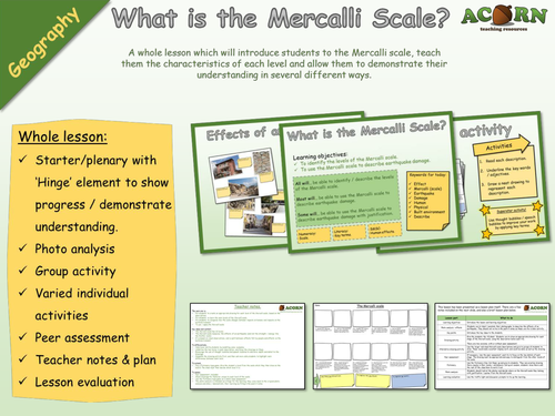
Geography - Natural Hazards - Earthquakes - Mercalli Scale drawing activity
A whole lesson which will introduce students to the Mercalli scale, teach them the characteristics of each level and allow them to demonstrate their understanding in several different ways.
Whole lesson:
Starter/plenary with ‘Hinge’ element to show progress / demonstrate understanding.
Photo analysis
Group activity
Varied individual activities
Peer assessment
Teacher notes & plan
Lesson evaluation
The main aim is…
For students to create an appropriate drawing for each level of the Mercalli scale, based on the descriptions.
For students to learn the main levels of the Mercalli scale.
For students to recognise how the scale changes between impacts on humans and impacts on the build environment.
To use / apply the Mercalli scale.
Key ideas and content…
The Mercalli scale has 12 levels.
The Mercalli scale measures the effects of an earthquake (and not the strength / energy like the Richter scale).
It is based on visual observations, and is split between effects felt by people and effects on the build environment.
To differentiate…
Help lower ability students by modelling some examples.
Underline the key terms in each description, and focus the drawings on these.
Encourage the use of thought bubbles and speech bubbles to add more depth and detail to the drawings.
Complete the drawing activity first, and then ask more able students to highlight main differences between each level.
To extend…
Play a Pictionary type game. Give the student a level from the scale which they then draw on the board. The class must then decide which level it is.
To assess…
Peer assessment included.
Check drawings for features unique to each level of the scale.
Use the Pictionary type game as a whole class assessment.
The photo analysis is intended as a Hinge for the learning, they come back to the original photo analysis and show / demonstrate their learning by filling in the post-it notes.
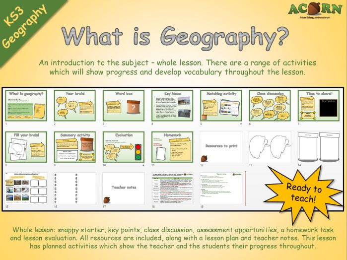
Geography - What is Geography?
An introduction to the subject – whole lesson. There are a range of activities which will show progress and develop vocabulary throughout the lesson.
The main aim is…
An introduction to the subject of geography.
To appreciate there are lots of topics within geography.
Key ideas and content…
Place is the main theme, and ties the subject together.
We study both the natural and the man made.
There are links and connections between the different topic areas.
To differentiate…
See lesson plan – red for lower and green for higher.
The acrostics could be used instead of the literacy activity.
Students could add to the word box as a pair or table.
To extend…
See lesson plan.
Students could research other topic areas and create their own activity.
This is intended as an introductory lesson – other activities could easily be included to further develop understanding.
To assess…
Use the literacy activity.
www.acornteachingresource.com
All reviews for our premium resources have been 5/5* (as of 3rd March 2017)

Urban issues and challenges - Mumbai (managing urban growth - squatter settlements)
A fully resourced and differentiated lesson teaching students about the development of squatter settlements in the context of Mumbai. Students will link characteristics and conditions (including the informal economy) to wider geographical processes.
Whole lesson > Photo analysis > Discussion prompts > Key ideas > Storyboard activities > Photo analysis – progress check > Exam style questions > Class discussion > Learning evaluation > Visual explainers > Homework > Lesson plan > Teacher notes > Fully resourced > Visually attractive and ready to teach!
The main aim is…
To establish the key characteristics of a squatter settlement.
To explain how they develop and then evolve over time.
To explain the difference between the formal economy and the informal economy.
To link squatter settlements to geographical concepts; urbanisation, rural-urban migration natural increase
Key ideas and content…
Squatter settlements are areas of informal housing where an informal economy often develops.
They evolve and change over time.
There are unique social / environmental conditions with impact quality of life.
They form because of a rapidly growing population.
To differentiate…
Several activities are differentiated – use the resources accordingly.
Photo analysis tasks can be completed as a class / groups / pairs
For the exam questions give lower ability students – display the connectives and key terms.
The discussion can be completed as a class / group.
To extend…
For the exam questions give time for middle and higher ability students to decide on their own connectives and key terms.
Provide a photo of a squatter settlement prior to the lesson – ask students to mind map what they know about squatter settlements. Add to / improve at the end.
Higher ability could read the definition of a squatter settlement and then write their own.
To assess…
The exam questions should be peer assessed.
There are several exam questions throughout the lesson, any of these could be given a mark and assessed.
The discussion prompts allow for summative assessment.
www.acornteachingresources.com