My shop is a non profit making concern & it supports homeless charities (Crisis, The Salvation Army & The Berwick Youth Project). Teaching has been my life & I continue to support learning around the World. My subjects were: History, Geography and Physical Education. I have competed in a wide variety of sports inc.: Gymnastics, Badminton, Rugby, Football, Athletics & many others. Check out my recent bundle with 11 of my best publications. A vast amount of support material on offer.
My shop is a non profit making concern & it supports homeless charities (Crisis, The Salvation Army & The Berwick Youth Project). Teaching has been my life & I continue to support learning around the World. My subjects were: History, Geography and Physical Education. I have competed in a wide variety of sports inc.: Gymnastics, Badminton, Rugby, Football, Athletics & many others. Check out my recent bundle with 11 of my best publications. A vast amount of support material on offer.
Home Study 2021. Improve your map skills at home. All income from this resource goes to homeless charities during 2021.
Map Skills - 50 page document with exercises and maps that can be photo-copied and re-used in different ways. Best suited to children between the ages of 10 and 14 (May be useful for Key Stage 4 revision work on map skills). All text, maps, photographs, sketches and graphics by the author … Ian Patterson
Home Study 2020. Have you got an Atlas at home? All homes need an Atlas. This resource is ideal for doing work linked to pages from an Atlas.
All income from this resource in 2020 will go to Homeless charities.
A 268 page document with over 50 outline maps from around the World. This resource book is to be used in conjunction with a school atlas. There are a multitude of exercises and challenges for students to use as homework or in the classroom with guidance from the teacher. Also included, there are over 180 photographs from the UK and around the World that can be used individually for lesson starters or as independent slide shows.
National Curriculum, Geography - This teaching resource offers a large proportion of the main elements included in the Key Stage 1, 2, 3 and 4 specifications. Location knowledge, Place knowledge, Human and Physical Geography and also elements of fieldwork skills have been covered in many different ways.
Almost every page has a Geographical question, exercise or challenge for a wide range of ability levels. Many of the photographs could also be used in PSHE lessons or Tutor Time to inspire discussion, comments and possibly written work.
Special areas of interest: China, Spain, France, Belgium, Malaga, Palm Springs, London, Bristol, WW1 Picardie and Flanders.
**Home Studies - 2021. All income for this resource will go to homeless charities. **
I believe that this project is perfect for Key Stage 2 and 3. The children will reap the benefits in their geographical studies when they progress to examination level in Key Stage 4. The Project offers an insight into the characteristics of the Yorkshire Dales National Park and it encompasses a taste of the History and the Geography of this diverse area of Northern England. There is a mix of written material, diagrams, maps challenges and photographs. The main target area is the subject of Humanities but in particular it is best suited for studies in Geography, Travel and Tourism and some aspects of History. Throughout this resource there is an offering of tasks for students to attempt. These challenges involve discussion, descriptive and analytical writing, drawing skills, numerical assimilation and all aspects of the requirements for satisfactory coverage of the National Curriculum in the UK. Sub topics include: Glaciation, Geology, Industrial Roots, Roads and Railways, Town and Countryside, Limestone Scenery, Farming, Mapwork Skills and a few others. In total there is enough work for at least 10 lessons that will encompass the full range of geographical skills within the one project. I believe that this resource would be best suited for children between the ages of 10 and 16 years and it can be adapted for a wide range of abilities. The work offered to the children can be carried out in the classroom and some sessions could make use of the IT room in order to extend the project. I would start by using an atlas and looking at its worldwide location as part of the bigger picture and then zoom in on its site and situation within the UK National Parks organisation. At this point I would introduce the children to one of the maps on offer within the project (Page 25). From this point onward the project can make full use of the 61 page resource document. I hope you enjoy studying this wonderful part of Northern England as much as I have both on the ground and under the ground over the past 35 years.
This is a Power Point Presentation about Poole, Dorset and the Jurrasic Coast. Within the commentary boxes each slide offers fairly simple writing or sketching challenges for students from Year 6 through to GCSE level. The study is presented in such a way that individual students can work through each challenge from home on a PC or lap top. The geographical skills involve drawing of maps, field sketches and analytical writing that will give each student familiarity with common geographical terminology. Working for between 1 and 2 hours per day, this project should last for about 7 session but may last up to 10 one hour sessions in total. There is potential for extension work using the many images that lend themselves to field sketch drawings. This resource is offered at a minimum price of £3 and all income will be forwarded to homeless charities in 2021. It is also offered at this time especially for parents and teachers who are providing children at home with appropriate educational challenges during the Covid crisis.
Income for this resource will go to homeless charities. The work serves to satisfy the type of work associated with field studies and research. The content targets Geography, Travel and Tourism and Business Studies students from 14 to 16 years of age. They will gain experience in handling data related to service industries. The work serves to satisfy the type of work associated with field studies and research. The data is presented on a spreadsheet that highlights the Service Industry of Poole in Dorset. Using the information, students will be able to propose a hypothesis and then attempt to prove or refute the chosen statement.
Within the folder there is a power point presentation that can be used independently as a collection of Geography topics about the English County of Dorset. Specifically it addresses the concepts of Site, Situation and Function of a settlement. The power point presentation alone can be used to support up to 10 contrasting lessons. The photographs can be used for introductions to a number of Human and Physical Geography topics including the following specifics and links:
Poole Port, Service Industry, Tourism, Shopping Streets, Spreadsheet statistics, Bays and Headlands, Lulworth Cove, Lulworth Village, Swanage Bay, Groynes, Stair Hole, Durdle Door, Corfe Castle, Dorset Geology, Settlements, Site, Situation, Function and finally a number of excellent photographs that can be converted to field sketch diagrams.
This resource is offered free to Geography teachers who are returning to the classroom after the challenges of lock down 2021.
This Geography resource challenges the children to test their knowledge and find out more about the cities and familiar places in the British Isles. The first part of the challenge refers mainly to the cities of the British Isles and it comes in the form of an anagram. The second part of the challenge focuses mainly on rivers or counties as well as other connections.
There are two formats on offer: 1) As a Power Point Presentation. This shows an image of the city or a familiar place. Above each image there is the anagram and also a follow up question. The children will enjoy the challenge of working out the anagram! Who will be first to solve the puzzle? The whole class can be guided through the challenge with the teacher supporting the progress with clues. The children can be encouraged to offer extra information about places they have visited. All of the children move on to the next challenge together and no-one gets left behind. There may be enough extension work to split this challenge into two lessons (10 images used in each lesson). 2) The second format offers this resource as a four sided A4 paper document that can be printed and used in various ways. It can be used as a homework project involving families or individuals. It may also be used as a cover lesson if any of the teachers are absent. Having completed the City Geography Challenge, a possible extension to this work could be a “Fact File Project” where each child produces five more pieces of factual information about each of the 20 images. Another possible use of the resource would be to compile sentences including the two pieces of geographical information from each challenge. This would help the children to develop their literacy skills. I believe that this resource can be used for children from 9 years through to 15 years of age. The younger children will need greater guided support than those in KS3 or KS4.
Please feel free to visit my TES shop to check out my resources. All income goes to three different homeless charities. I hope you enjoy your return to the classroom. Best wishes to you all.
What would you do and who would you turn to if you found yourself homeless at this time next year?!
This resource supports three homeless charities. For only £2 you will receive a resource that highlights both Geography and History across the length and breadth of Britain. At the same time you will be helping people who find themselves on the streets and need our help to survive. The resource comes in two files. One is in Power Point format and the other is a word file that includes both a quiz challenge and an extended fact file about many different topics. These topics include: Coventry Cathedral, Edinburgh Castle and the geological feature known as a “Crag and Tail”, the Holy Island of Lindisfarne, Titanic, William Shakespeare, Isambard Kingdom Brunel, Oliver Cromwell and the “New Model Army”, Hadrian’s Wall and Features of intrusive, extrusive volcanic activity and many more.
The resource can be used for children between the ages of 10 and 16 as either a review of “The Geography and History of the British Isles” or as a Power Point quiz challenge. Many of the individual topics can be used to introduce stand alone lessons or to stimulate discussions.
The Tudors - From Start to Finish. This resource has been compiled as a time line of events and can be used as an independent home study or Zoom project. This Story about the Tudors is a comprehensive document in the form of a Power Point Presentation. There are over 100 images that give a taste of all that happened during this period of History. The study looks at the highs and lows of the main characters that lived and died during the reign of the Tudors. The whole package takes the form of 15 power point lessons that covers almost every possible topic that can be included within the Tudor Period. Topic examples include: Religion, Rebellion, War, Family, Execution, Affairs at home, Affairs abroad and Slavery to name but a few. Each lesson is concluded with a revision quiz that gives the children the opportunity to develop their writing skills. As all teachers know, History and use of the English language go hand in hand. This resource offers children from the age of 9 through to 16, a colourful opportunity to fully understand what happened during the reign of the Tudors as well as offering an extended project that develops individual literacy skills. The study can be delivered on three levels giving teachers the opportunity to use this resource with different age groups and ability levels.
KS2 topics covered: Teaching Chronology, Black People / Slavery, Spanish Empire, Literacy and History.
KS3 topics covered: Early Modern (16th & 17th Century), The Reformation, Henry VIII + Elizabeth I.
All commission income this year (2022) will go to three different homeless charities. They are: Crisis, Salvation Army and The Berwick Project (Keeping young people off the streets).
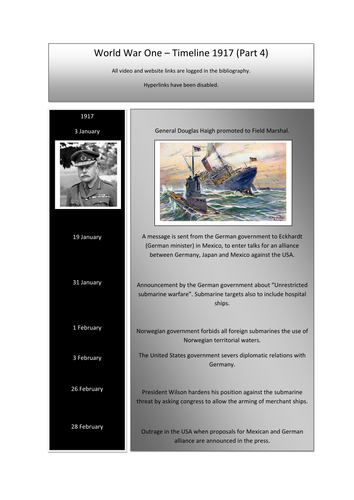
This resource can be used as a revision document or as a resource for teaching topics about WW1 during the year 1917. Resource links include: Count Von Zeppelin, Russian Revolution, Lawrence of Arabia, Battles in the Passchendaele area and tanks in use at the Battle of Cambrai. There are a number of links to web sites and video footage for delivering lessons to both KS3 and KS4 History students. Year 11 History examination students will be able to use specific sections of this folder to revise from. Note … hyperlinks have been disabled but can be easily restored.
Orienteering - PPP9
Navigation, Gathering Points and Handrails.
This Power Point Presentation aims to help competitors in the art of navigation. Two ways of making the navigation challenge easier, involves making the most of gathering points and Handrails. The use of these navigation skills can help the novice to progress into an experienced, confident and successful competitor. The presentation offers the following: 1. Map examples of linear map symbols that help the runner to maintain a parallel track to the intended control point. Examples of linear features might be a) a fence, b) a wall, c) the edge of woodland. These are a few of many possibles. 2. In contrast gathering points are a number of isolated map symbols that can also help the runner to progress accurately between two control points. This is particularly useful when following a compass bearing. Isolated map features might include a) a large rock, b) a small thicket, c) an isolated tree d) a ditch running across the direction of travel, etc. There are many more examples. Long navigational legs may have as many as 5 or more gathering points. Gathering points also helps to sub-divide the leg into specific distances.
This presentation also includes a section on how to set a compass bearing using the Silva (plate) compass. As long as you have the map and compass in your hand you will not be lost! However, you may be unsure of your exact location - In these circumstances - check the orientation of the map and look for prominent physical or man made objects nearby to relocate.
Handrails and gathering points help to create bite size challenges. Learning these advanced skills help to establish stress free progress in an Orienteering event. Enjoy the challenges.
Orienteering - PPP7
Symbols - Quiz One
In order to navigate an Orienteering map, it is essential to have a fair grasp of the map symbols. Presentation 7 is offered in the form of a Quiz. Included are 25 contrasting examples.
Included are: Vegetation types, man-made structures, water features, natural formations and a variety of other common inclusions that can be found on Orienteering maps.
Orienteering - PPP8
Symbols - Quiz Two
As with Presentation 7 this is the second of two presentations that will help the Orienteer to become familiar with the map symbols. Presentation 8 again offers a selection of 25 map symbols. They are presented as a quiz challenge that can be repeated several times. This will help individual orienteers to become familiar with the many symbols included on Orienteering maps. A mixture of all symbol types has been included.
A Taste of Orienteering - Getting Ready for Your First Event. This chapter aims to help the beginner to become familiar with the many experiences and challenges facing the newcomer to this exciting outdoor sport.
This Power Point Presentation is the second in a series of coaching notes for this amazing sport of Orienteering. It is dedicated to our departed friend, James Ross who was an established and successful Orienteer. He was a member of the well-established Malaga Orienteering Club. All commission gained from this resource will be donated to selected Cancer organisations.
So where do we start? Here is a list of the topics covered in this presentation:
Checking out your local Club and what is on offer. 2. Make contact and find out the many activities and experiences available. 3. Events can be either “Town and Country” (Urban or Rural), a huge contrast. 4. Become familiar with the Club websites. 5. What might we expect to find at the start line? 6. The first few seconds of any test or race are vitally important especially for novices! 7. As we progress, we will become familiar with both the map and the compass. 8. Gradually we will gain confidence and become familiar with directions, distances and many contrasting landscapes. 9. A clever thumb will improve our navigational skills!? 10. At the end of each event we will become familiar with the finish line and checking in at the download station. 11. Finally we should show gratitude to the planners and organisers who give of their time freely for the benefit of others and this incredible outdoor sport.
Orienteering is very much a family sport, and it offers huge benefits to young and old alike. Check out this presentation and become involved in something very special.
This resource is offered as an introduction to how maps evolved and the subsequent development of Orienteering as a sport. It is offered as a Power Point Presentation and it lays the foundation for a programme of 9 more presentations that highlight the many skills and coaching topics to be experienced in this amazing sport (Orienteering). The ten presentations have been written in both English and Spanish. Many of the slides show the diversity of the Spanish landscape as captured by the many members of “The Malaga Orienteering Club in Spain.” The presentations can be adapted for viewing by Upper junior students (9 - 10 yrs.) through to adult age groups. This presentation includes topics such as: Comparisson of ancient maps through to modern day orienteering maps; Early maps and cartography; The compass rose; The Earth’s magnetic field, The magnetic compass and how it can be used with the Orienteering map. The presentation sets the foundation for many more coaching aspects covered in the follow up programme of wide ranging topics. These resources are a non profit making venture and any income will be forwarded to three selected homeless charities (Crisis, The Berwick Project and the Salvation Army). As an extension to the use of this resource, teachers may wish to use the text, images and possible video links to other topics such as: Geographical landscapes, The Spanish language, The History of Maps and as an introduction to the sport of Orienteering. The introductory videos (one of two in the presentation), gives a true taste of this amazing outdoor sport. Permission to show the videos in this and all ten presentations has been granted by Malaga Orienteering Club with the gratitude of (Ian Patterson) the author of this presentation.
The sport of Orienteering needs to be broken down into bite-size skills so that the beginner can establish the most important principles of this incredible activity. In this presentation I have selected ten elements that I believe to be essential learning steps for the novice orienteer. I have included the following topics in order to lay the foundations for success in this activity:
Knowing your north from your south! 2. Translating the symbols into an accurate mental image of the land features. 3. Making the most of the map key. 4. Getting to grips with scale and distances. 5. Understanding contours and being able to convert the patterns into mental pictures. 6. Keeping in touch with your exact location by using your thumb! 7. A personal understanding of your stride distancing. 8. Making use of rough bearings. 9. Knowing how to use map handrails. 10. On a navigation leg, make the most of the collecting or gathering features between control points.
These key principles of navigation and map reading skills will serve you well in this incredible sport. As with all my resources, I offer this resource at minimum cost in order to support my three chosen homeless charities. I am grateful to the Malaga Orienteering Club for permission to use many of the images and videos on offer in this presentation.
This chapter highlights the structure and content of an Orienteering Event and it is presented as a Power Point Presentation. The key elements include: The map and planning, Orienteering controls and the officials (the people behind the scenes), Preparing the maps and checking out the lay of the land, Advertising the event and taking in the entries, Setting up a suitable start and finish zone. Other interesting features include aspects of coaching, working with young competitors and also the benefits of family participation.All in all a sport with a healthy outlook and well worth trying.
This resource is part of a larger coaching document and all presentations will serve to support three homeless charities.
This resource is a mini project about Africa. It is presented as a 25 question quiz that can be expanded for perhaps 3 to 6 lessons encompassing a wide variety of topics. The main theme of the resource targets Africa as a continent. Sub-themes (mainly Geography but also some History), includes topics such as: Biomes, Ecosystems, Climate, wildlife, River Basins, Deltas, Mountains, Natural Vegetation, Global Warming as well as several other Geographical themes.
There are many ways for delivering this material:
Each lesson can start with a question-and-answer session with the use of atlases or a projected image of Africa (The focus can be on Physical Geography, Human Geography or both.)
Focus on the first 5 questions in discussion. After 15 minutes discussion and directed teaching, Ask the children the first 5 questions as a mini challenge. As an immediate follow up show the first 5 answers from the fact file presentation. The test result is not as important as the discussion and the follow up discussion. Using this framework there is the possibility for six very contrasting lessons.
There are World map outline challenges at the end of the resource file.
Any commission from this resource will be sent to the homeless charity “CRISIS” UK.
Have fun and enjoy the teaching experience.
Advice and a Warning … Please note that this play makes use of sound effects like irate animals, a rather mad parrot and a deaf old lady who breaks wind!! If you use this resource, I recommend using it in the final lesson of the day. It is not for use by teachers who are faint hearted or do not have a good rapport with their students. Read on if you are interested.
This is both a short story and a short play about Diego the Parrot. The title of the play is “My Neighbour Has A Parrot”. I used to enjoy interactive lessons with my students and in partnership with my classes we used to produce plays, drama sketches and pantomimes. These were the most memorable experiences in my career as a teacher. This resource targets English and Drama or it can be used as a platform for a short stage production. Acting out plays has always been a winner for me. There are lots of sound effects included in this production and it affords the opportunity to have lots of fun with your students. As a play it would last between 10 and 15 minutes. The main characters in this production could include a narrator, old man, old lady, parrot and possibly a sound effects expert! I would target this resource at Key Stage 2 and 3 (Ages 8 to 14 year old). Initially I would read the story to the class (with the sound effects) and then develop the production as a whole class exercise and then, perhaps, in groups of between 4 and 5 children. The main aim of this classroom activity is 1) Building inner confidence and 2) Having fun in the classroom. Further developments can involve creative writing about Diego the parrot. One in particular that I have used in the past would be “Diego and the Ventriloquist”. Each child can have a go at performing and writing a small individual sketch for fun. A toy parrot strapped to the shoulder would be a useful extra. I hope you have fun with this resource.
My shop supports the Berwick Youth Project. This charity helps to keep young people safe and tries to prevent them from ending up on the streets or homeless.
All 2021 income on this resource will go to Homeless Charities. Learn at school or at home about USA Cities.
This presentation can be used for children between the ages of 9 and sixteen. There are fifty five slides and thirty nine pages of additional resource materials. I have selected the following cities because of their contrasting site, situation and geographical locations. They are: Boston, New York, Washington DC, Chicago, Detroit, Las Vegas, Los Angeles, San Francisco and New Orleans. This selection of cities offers extended studies in both Physical and Human Geography. Included in the slide notes and the resource file are suggested work challenges involving on line work, historical links, geographical writing skills, discussions and other map drawing exercises. The presentation can be targeted at nine and ten year old students but it will be necessary to use the shortened version of the script. Children between the age of eleven and fourteen should be able to cope well with most of the challenges. Key Stage 4 (fourteen to sixteen years) students involved in examinations will be able to link this resource with a large range of the exam topics. Some examples include: Boston and New York - Settlements, site, situation and geographical location. New Orleans - Flooding, Mississippi Drainage Basin, River features including deltas. Detroit - Industrial and population change. Chicago and Detroit - Location, Waterways and Trade, Glaciation and the Great Lakes. Los Angeles and San Francisco - Environmental Hazards and Tourism. Las Vegas - Desert environment, Water resources and the Entertainment Industry. Washington DC - Capital City, history, location, population, government and tourism. There are several IT challenges on offer that involve constructing a quiz word grid, following the course of the River Colorado by using on line maps, developing knowledge of site, situation and geographical location with a starting point in Downtown Chicago. The whole project is aimed at developing a wide range of geographical knowledge along with IT skills and the opportunity to improve writing techniques in preparation for higher level studies. I personally would use this resource for Year 9 groups in preparation for Key Stage 4 Geography. The History content makes it just that little bit more interesting.
A vast collection of teaching materials from a lifetime of experience. 60% saving. This large bundle will serve a large number of young and experienced teachers alike. In as few words as possible I will explain the potential gains to be had from this vast collection of History, Geography and General Knowledge.
A World and UK collection of outline maps that can be used alongside an Atlas or independently. Hundreds of images & exercises on World Geography. They serve to assist in a huge variety of Humanities lessons.
Check out this map-work resource that covers all of the skills required to read maps and fully understand the use of maps.
This resource gives us a taste of ten cities in the UK. It offers fact file projects and worksheets.
Similar to that listed above. This Power Point Presentation presents 9 contrasting cities in the USA. It gives a taste of both History and Geography.
The Africa Project. This presentation offers up a huge contrast between the physical and human geography of the African Continent. It takes the shape of a Power Point Presentation and progresses through each chapter as a quiz.
Close to my heart are the Yorkshire Dales. One of my favorite National Parks where I spent many days roaming the hills and diving into numerous caves. Like all of my resources there are many images, exercises, diagrams, and support materials. Topics covered vary from field sketches to glacial features and understanding maps that are linked to the history of industry and how people work the land. A thoroughly eclectic mix of knowledge and experience.
On the History front, this resource tracks the whole journey through World War One as a time-line of information. There are many links to old cinema broadcasts that help to transport the students back in time.
As a History teacher, I spent a number of years delving into the life of Adolf Hitler. This resource is entitled “Development of a Dictatorship”. My most downloaded resource is this time-line. It tracks all of Hitler’s progress from 1918 to his death in 1945. Again, there are many links to specific events like Dunkirk, Pearl Harbour, D-Day landings and many more. Glancing through this resource gives our History students excellent practice at mastering their own time-lines.
The Reign of the Tudors. This is another time-line of events with both images and notes that once again can help younger students start to get the idea of putting events in the correct order.
The Story of the Tudors is an in-depth Power Point Presentation that can be broken down into bite size quizzes. This presentation serves to guide you and the children from start to finish through the whole Tudor Period.
During the Pandemic Period, my wife and I wrote many General Knowledge quizzes for parents and teachers. They target children from Years 5 to 9 but many of them serve older age groups. Each quiz covers a huge variety of topics. Answers contain extra detail.
Ten Orienteering power point presentations, highlighting the many different skills involved in this incredible individual, family and team sport. There are many maps, images and videos included, that help the individual competitor to develop their knowledge and become familiar with the multitude of skills and experiences on offer in Orienteering. Topics included are: Landscapes, Historical connections, Navigation, Mapwork skills, Beginners advice, What to expect at your first event and many more coaching elements.
This resource can be used in Spain and the UK as the slides and commentary are written in both English and Spanish.
The presentations would be ideal to use as an introduction for examination candidates who have chosen the Outdoor Adventurous Sport of Orienteering as one of their physical activities. The whole resource would serve as an ideal introduction and learning experience for both individual candidates and families who become involved in this sport.
This resource is on offer for a limited period (extended from 3 to 12 months) at half price.
Any income from this resource will be sent to the following three homeless charities (The Berwick Project, The Salvation Army and Crisis).
Thank you … Ian Patterson.