More than 50 pages of Blackline Masters for upper primary/lower secondary students.
All worksheet activities are completed with the fabulous Google Earth application which is free to download on to your PC or Mac from earth.google.com. Activities require minimum teacher direction and provide maximum learning for the student.
_______________________________________________________
Contents:
• Constellation conundrum
• Landmarks
• Cruise around the world
• Help!! Endangered species
• The Galapagos Islands
• Continents
• Google Moon
• The Earth's Grid System
• Make the World a Better Place
• Mission to Mars
• Majestic Mountains
• My Google Earth Autobiography
• Mysterious Locations
• National Parks
• Ocean Explorer
• Ocean Investigations
• The Olympics
• The ABCs of Google Earth
• Bonjour, Mon Ami
50 plus pages
3 weeks duration
Activity Sheets for the Middle School students. Great fun solving problems using Google Maps(and Google Earth). Simple instructions but challenging activities.
I have found that the students in my class need very little instruction to complete the tasks, so long as they understand the Google Maps tools.
Google account is not required - just access to the Google Maps online.
Table of Contents
1. Creating a Travelling Distance Chart
2. Solve the Riddle
3. A Different Type of Easter Egg
4. Fantasy Island
5. Landmarks Around the World
6. Cruising the Seas
7. All about Continents
8. The Earth’s Grid System
9. From Pegman’s Point of View
10. Time & Weather Clues
11. Sites with a View
12. Home Sweet Home
13. Street View Safari
14. Who Am I?
15. National Parks
16. Your Place
17. A Mission for Agent Pegman
18. Things to do on Google Earth
*********************************************
29 pages
1 month duration
Answer key included
Google Earth has over 50 layers of information and all are explained in this booklet, along with student activities designed to allow the student to explore each of the layers and track down the type of fascinating information that can be found on each layer.
Layers are also given a value rating so that teachers can go directly to the most valuable layer with the most educational information.
The booklet includes definitions and activities around the following Google Earth layers:
- Borders and Labels
- Photos
- 3D Buildings
- Ocean
- Weather
- Gallery
- Global Awareness
- and more
Key points of interest are highlighted and quirky little tips are included.
This is a true reference book for any student or teacher who works with Google Earth.
28 pages
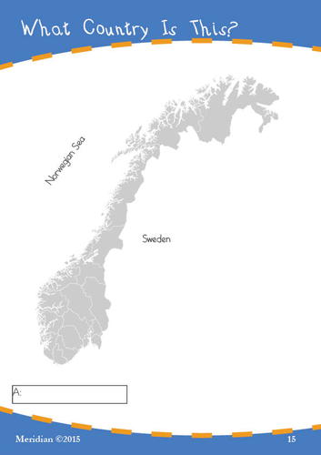
EVEN MORE printable maps with a simple clue that students use to determine what country is outlined on the sheet.
The first pack of What Country is This? was so popular, that I have made another pack
Again, the clue might be a longitude or latitude, a key city, or a geographical feature.
The task is simple, but the activity is challenging.
Students can also use the shape of the country to help in working out the name of the country.
The worksheets have an answer key at the end. There are 22 maps in all. Some sample pages shown.
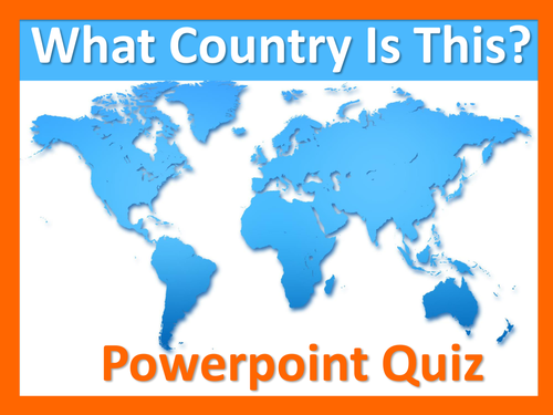
Powerpoint slides of maps with a simple clue that can be used as a class activity.
The task is to determine what country is outlined on each slide. First the country outline is shown, then click on to a single clue to help identify the country.
The clue might be a longitude or latitude, a key city, or a geographical feature. Use Google Earth to find the country from the clues provided.
The task is simple, but the activity is challenging.
Once the students identify the country from the shape and/or the clue, click on to see the answer.
A great source I used to make these worksheets was http://www.amcharts.com/svg-maps/. Here you can download the outline of the maps and import them into Illustrator and move states around or whatever you might like to do for your own worksheets.
There are 22 maps in all.
Slideshow sequence shows the answer at final transition.
(Sample pages only shown here)
Printable maps with a simple clue that students use to determine what country is outlined on the sheet.
The clue might be a longitude or latitude, a key city, or a geographical feature.
The task is simple, but the activity is challenging.
Students can also use the shape of the country to help in working out the name of the country.
A great source I used to make these worksheets was http://www.amcharts.com/svg-maps/. Here you can download the outline of the maps and import them into Illustrator and move states around or whatever you might like to do for your own worksheets.
The worksheets have an answer key at the end. There are 22 maps in all. The maps shown here are samples only.
This is a pack of worksheets with Maths problems students can do on Google Maps. The problems cover a range of activities, but my class particularly liked the activity based on Disneyland where they had to zoom in on Street View as well as use the Earth function to mathematically calculate the number of car parks in a particular structure at Disneyland, and also calculate the commercial profitability of the car park.
This is a multi-skilled pack for Middle School students and those who have bought my other packs over the years (thank you all!) you will know that each sheet is well laid out, nicely presented and encourages the student to work independently on each activity.
As well as the Disneyland activity, the pack includes:
- designing a road trip
- searching for mathematical street names in a particular location(we found more than 10 names!)
- researching odd mathematical locations
- measuring and comparing distance
- and more
10 pages of worksheets, PLUS an answer key.