Thank you for visiting! Here you will find a selection of printable, interactive worksheets for your classroom: Basic Geography worksheets with simple maps, ESL, Spanish, Bible, Reading Comprehension and more. I hope you find the resources useful! Reviews are welcome and very much appreciated. Thank you so much.
Thank you for visiting! Here you will find a selection of printable, interactive worksheets for your classroom: Basic Geography worksheets with simple maps, ESL, Spanish, Bible, Reading Comprehension and more. I hope you find the resources useful! Reviews are welcome and very much appreciated. Thank you so much.
Introduce your learners to Kenya with two worksheets (plus answer key). Your students will read a brief introduction to Kenya (location, capital, flag, language), write ‘Nairobi’ next to the star on the map to show the location of the capital, trace the line of the equator across Kenya, color the small map and flag, and use the map and compass to answer 9 questions on page 2. Colored pencils and a pen or pencil are needed for this activity. No other prep needed. Basic Geography worksheet with a simple map to introduce Kenya and practice cardinal and ordinal directions.
For use with Interactive Notebooks: After the worksheets are completed, students can cut out the map and flag and paste into the notebook under the topic of Africa / Sub-Topic: Kenya. Under the map and flag, students can write a summary in their own words of what they now know about this country. Collect worksheets for other countries of Africa to add to the notebook! Please browse this store for a selection of worksheets for other countries of Africa (and beyond!).
Thank you so much for using my Geography worksheets in your classroom! Reviews are welcome and very much appreciated.
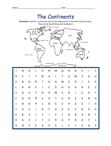
Introduce your students to the 7 continents with this printable handout of 2 worksheets (plus answer key). Your students will write the name of each continent on the map: Africa, Antarctica, Asia, Europe, North America, Oceania (Australia), and South America, trace the line of the equator, color the small map, and use the map and compass to answer 7 questions. Colored pencils and a pen or pencil are needed for this activity. No other prep needed. Basic geography worksheet with a simple map to introduce the continents and practice cardinal and ordinal directions.
For use with Interactive Notebooks: After the handout is completed, students can cut out the map of the 7 continents and paste into the notebook. Under the map, students can write a summary in their own words of what they now know about the continents. Collect handouts for countries of Africa, Antarctica, Asia, Europe, North America, Oceania/Australia, and South America to add to the notebook! Please browse this store for a selection of printable handouts.
Thank you so much for using my Geography worksheets in your classroom! I hope you find them useful!
Find the 7 continents and surrounding oceans in the Word Search Puzzle. They can be found forward or backward: Africa, Antarctica, Asia, Europe, North America, Oceania, South America, Arctic, Atlantic, Indian, Pacific, Southern.
Thank you for using my worksheets in your classroom! Please browse this store for a selection of printable worksheets: Geography, Spanish, Reading Comprehension, Bible, and more.
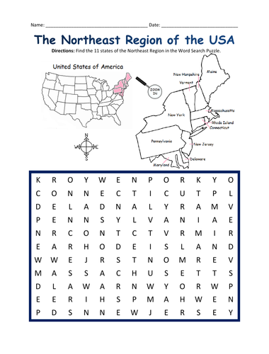
Introduce your students to the NORTHEAST REGION of the United States with this printable handout of one page (plus answer key). Using the map of the Northeast Region, find the eleven states in the word search puzzle: Connecticut, Maine, Massachusetts, New Hampshire, Rhode Island, Vermont, Delaware, Maryland, New Jersey, New York, Pennsylvania.
Other regions also available! Please browse this store for printable handouts for other regions of the United States and other Geography worksheets!
-SOUTHWEST REGION MAP AND WORD SEARCH
-MIDWEST REGION MAP AND WORD SEARCH
-SOUTHEAST REGION MAP AND WORD SEARCH
-WEST REGION MAP AND WORD SEARCH
Thank you so much for using my Geography worksheets in your classroom!
Using the map of the Middle East, fill in the blank letters for each of the 17 countries: Bahrain, Cyprus, Egypt, Iran, Iraq, Israel, Jordan, Kuwait, Lebanon, Oman, Palestine, Qatar, Saudi Arabia, Syria, Turkey, UAE (United Arab Emirates), Yemen.
Thank you for using my printable handouts in your classroom! Please browse this store for a selection of Geography worksheets for countries of the Middle East (and beyond!).
Introduce your learners to the country of CAMBODIA in Southeast Asia with this printable or digital handout of two worksheets (plus answer key). Your students will read a brief overview of Cambodia (location, capital, language, flag), write ‘Phnom Penh’ next to the star on the map to show the capital, trace the lines of the Tonle Sap and Mekong River, color the small map, and use the map and compass to answer 8 true/false questions on page 2. Colored pencils and a pen or pencil are needed for this activity. No other prep needed. Basic Geography worksheet with a simple map to introduce Cambodia and practice cardinal and ordinal directions.
For use with Interactive Notebooks: After your students complete the worksheets, they can cut out the map and flag of Cambodia and paste into the notebook under the topic of Asia / Sub-topic: Cambodia. Under the map, students can write a summary in their own words of what they now know about this country. Collect worksheets for other countries of Asia to add to the notebook! Please browse this store for a selection of printable worksheets for other countries of Asia (and beyond!)
Thank you so much for using my Geography worksheets in your classroom! Reviews are welcome and very much appreciated.
Included: Thailand, Laos, Vietnam, Buddhism, Angkor Wat, Khmer, Mekong River
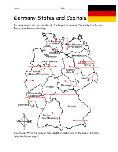
Introduce your students to the 16 states and capital cities of Germany with three worksheets (plus answer key). Using the list of states and capitals on page 2, your students will write the capital city of each state on the map of Germany (page 1). Then answer 8 true/false questions on page 3.
States - Capitals included:
Baden-Württemberg - Stuttgart
Bavaria - Munich
Berlin - Berlin
Brandenburg - Potsdam
Bremen - Bremen
Hamburg - Hamburg
Hesse - Wiesbaden
Lower Saxony - Hanover
Mecklenburg-Vorpommern - Shwerin
North Rhine-Westphalia - Düsseldorf
Rhineland-Palatinate - Mainz
Saarland - Saarbrücken
Saxony - Dresden
Saxony-Anhalt - Magdeburg
Schleswig-Holstein - Kiel
Thuringia - Erfurt
Thank you so much for using my worksheets in your classroom! I hope you find them useful. Reviews are welcome and very much appreciated. Please browse this store for more Geography worksheets!
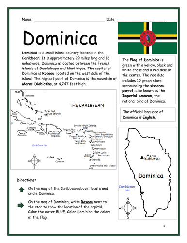
Introduce your learners to the island country of Dominica with two printable worksheets (plus answer key). Simple map activity and reading comprehension questions. Your students will read a brief introduction to Dominica (location, capital, flag, language), locate and circle Dominica on the map of the Caribbean (map 1), write ‘Roseau’ next to the star on the map of Dominica (map 2) to show the location of the capital, color the map, and use the reading passage, maps and compass to answer 10 true/false questions on page 2. Colored pencils and a pen or pencil are needed for this activity. No other prep needed. Basic Geography worksheet with a simple map to introduce Dominica and practice cardinal and ordinal directions. Print and Go!
For use with Interactive Notebooks: After the worksheets are completed, students can cut out the map and flag and paste into the notebook under the topic of (example) The Caribbean / Sub-topic: Dominica. Under the map, your students can write a summary in their own words of what they now know about Dominica. Collect worksheets of other countries of the Caribbean (or North America) to add to the notebook! All available in this store.
Thank you so much for using my Geography worksheets in your classroom! I hope you find them useful. Reviews are welcome and very much appreciated! Please browse this store for more worksheets to introduce your learners to the countries of the world!
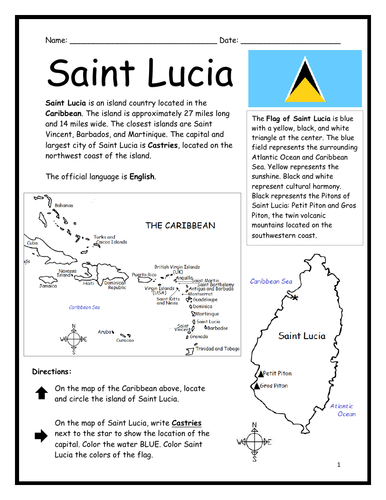
Introduce your learners to Saint Lucia with two printable worksheets (plus answer key). Simple map activity and reading comprehension questions. Your students will read a brief introduction to Saint Lucia (location, capital, flag, language), locate and circle Saint Lucia on the map of the Caribbean (map 1), write ‘Castries’ next to the star on the map of Saint Lucia (map 2) to show the location of the capital, color the map, and use the reading passage, maps and compass to answer 9 true/false questions on page 2. Colored pencils and a pen or pencil are needed for this activity. No other prep needed. Basic Geography worksheet with a simple map to introduce Saint Lucia and practice cardinal and ordinal directions. Print and Go!
For use with Interactive Notebooks: After the worksheets are completed, students can cut out the map and flag and paste into the notebook under the topic of (example) The Caribbean / Sub-topic: Saint Lucia. Under the map, your students can write a summary in their own words of what they now know about this country. Collect worksheets of other countries of the Caribbean (or North America) to add to the notebook! All available in this store!
Thank you so much for using my Geography worksheets in your classroom! I hope you find them useful. Reviews are welcome and very much appreciated! Please browse this store for more worksheets to introduce your learners to the countries of the world!
Included: Petite Piton and Gros Piton.
SPED, Resource Room Teacher, Primary school, elementary.
Introduce your students to Bolivia with this printable handout of two worksheets (plus answer key). Your students will read a brief overview of Bolivia (location, capital, flag, language), write 'Sucre' next to the star on the map to show the capital, color the small map and flag, and use the map and compass to answer 7 questions. Colored pencils and a pen or pencil are needed for this activity. No other prep needed. Basic Geography worksheet with a simple map to introduce Bolivia and practice cardinal and ordinal directions.
For use with Interactive Notebooks: After the handout is completed, students can cut out the map and flag and paste into the notebook under the topic of South America/Sub-topic: Bolivia. Under the map, students will write a summary in their own words of what they now know about this country. Collect handouts for other countries of South America to add to the notebook! Please browse this store for a selection of printable handouts for other countries of South America (and beyond!).
Thank you so much for using my Geography worksheets in your classroom!
Introduce your learners to Panama with two printable worksheets (plus answer key). Your students will read a brief introduction to Panama (location, capital, flag, language), write ‘Panama City’ next to the star on the map to show the location of the capital, color the small flag and map, and use the map and compass to answer 10 questions on page 2. Colored pencils and a pen or pencil are needed for this activity. No other prep needed. Basic Geography worksheet with a simple map to introduce Panama and practice cardinal and ordinal directions.
For use with Interactive Notebooks: After the worksheets are completed, students can cut out the map and flag and paste into the notebook under the topic of (example): Central America or Spanish-Speaking Countries / Sub-Topic: Panama. Under the map and flag, students can write a summary in their own words about what they now know about this country. Collect worksheets for other countries of Central America (or Spanish-Speaking Countries) to add to the notebook! All available in this store! Please browse this store for worksheets for countries of Central America and beyond!
Thank you so much for using my Geography worksheets in your classroom! I hope you find them useful. Reviews are welcome and very much appreciated! Please browse this store for worksheets to introduce your learners to the countries of the world!
Key words: Panama canal, Spanish, cardinal, ordinal directions.
Introduce your learners to Ireland with this printable handout of two worksheets (plus answer key). Your students will read a brief overview of Ireland (location, capital, flag, language), write ‘Dublin’ next to the star on the map to show the location of the capital, color the small map and flag, and use the map and compass to answer 6 multiple-choice questions on page 2. Colored pencils or and a pen or pencil are needed for this activity. No other prep needed. Basic Geography worksheet with a simple map to introduce the country of Ireland.
For use with Interactive Notebooks: After completing the worksheets, students can cut out the map and flag and paste it into the notebook under the topic of Europe / Sub-Topic: Ireland. Under the map, students will write a summary in their own words of what they now know about this country. Collect worksheets for other countries of Europe to add to the notebook! Please browse this store for a selection of worksheets for other countries of Europe (and beyond!).
Thank you so much for using my Geography worksheets in your classroom! I hope you find them useful. Reviews are welcome and very much appreciated.
Introduce your students to PORTUGAL with two worksheets (plus answer key). Your students will read a brief introduction to Portugal (location, capital, flag, language), write ‘Lisbon’ next to the star on the map to show the location of the capital, color the small flag and map, and use the map and compass to answer 6 questions on page 2. Colored pencils and a pen or pencil are needed for this activity. No other prep needed. Basic Geography worksheet with a simple map to introduce Portugal and practice cardinal and ordinal directions.
For use with Interactive Notebooks: After completing the worksheets, students can cut out the map and flag and paste into the notebook under the topic of Europe / Sub-Topic: Portugal. Under the map and flag, students can write a summary in their own words of what they now know about this country. Collect worksheets for other countries of Europe to add to the notebook! Please browse this store for worksheets for other countries of Europe (and beyond!).
Thank you so much for using my Geography worksheets in your classroom. I hope you find them useful! Reviews are welcome and very much appreciated.
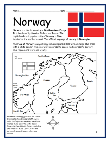
Introduce your learners to NORWAY with this two worksheets (plus answer key). Your students will read a brief introduction to Norway (location, capital, flag, language), write ‘Oslo’ next to the star on the map to show the location of the capital, color the small flag and map, and use the map and compass to answer 6 questions on page 2. Colored pencils and a pen or pencil are needed for this activity. No other prep needed. Basic Geography worksheet with a simple map to introduce Norway and practice cardinal and ordinal directions.
For use with Interactive Notebooks: After completing the worksheets, students can cut out the map and flag of Norway and paste into the notebook under the topic of Europe / Sub-Topic: Norway. Under the map and flag, students can write a summary in their own words of what they now know about this country. Collect worksheets for other countries of Europe to add to the notebook! Please browse this store for worksheets for other countries of Europe (and beyond!).
Thank you so much for using my Geography worksheets in your classroom! Reviews are welcome and very much appreciated.
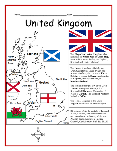
Introduce your learners to the United Kingdom with three interactive worksheets (plus answer key). Page 1: Your learners will read a brief introduction to the United Kingdom (location, capital, flag, language), write the capital of England, Scotland, Wales and Northern Ireland next to each star on the map, and color the water surrounding the UK BLUE. Page 2: Use the map and compass to answer 6 multiple choice questions. Page 3: Match the flag to the country: England, Scotland, Wales and Northern Ireland. Page 4: Answer Key. Basic Geography worksheet with a simple map to introduce the United Kingdom.
For use with Interactive Notebooks: After completing the worksheets, students can cut out the map and flag and paste into the notebook under the topic of Europe / Sub-Topic: United Kingdom. Under the map and flag, students can write a summary in their own words of what they now know about the UK. Collect worksheets for other countries of Europe to add to the notebook! Please browse this store for worksheets for other countries of Europe (and beyond!).
Thank you for using my Geography worksheets in your classroom! I hope you find them useful! Reviews are welcome and very much appreciated.
Introduce your learners to the continent of ANTARCTICA with this printable worksheet of 2 pages (plus answer key). Your students will read a brief overview of Antarctica (location, climate, etc), color a small map, and answer 7 true/false questions on page 2. Basic Geography worksheet with a simple map to introduce the continent of Antarctica.
Thank you so much for using my Geography worksheets!
Includes: Victoria Land, Wilkes Land, Ice Shelves: Ross, Ronne, and Amery.
Introduce your learners to Papua New Guinea in Oceania with two worksheets (plus answer key). Your students will read a brief introduction to Papua New Guinea (location, capital, flag, islands, language), locate and circle Papua New Guinea on the map of Oceania, write ‘Port Moresby’ next to the star on the map of Papua New Guinea to show the location of the capital, color the small map, and use the maps and compass to answer 10 true/false questions on page 2. Colored pencils and a pen or pencil are needed for this activity. No other prep needed. Basic Geography worksheet with a simple map to introduce the country of Papua New Guinea and practice cardinal and ordinal directions.
For use with Interactive Notebooks: After the worksheets are completed, students can cut out the map and flag and paste into the notebook under Oceania/Sub-Topic: Papua New Guinea. Under the map and flag, students can write a summary in their own words of what they now know about this country. Collect worksheets for other countries of Oceania to add to the notebook! Please browse this store for a selection of worksheets for other countries of Oceania (and beyond!).
Thank you so much for using my Geography worksheets in your classroom! I hope you find them useful. Reviews are welcome and very much appreciated!
Introduce your students to the 20 regions and capital cities of Italy with three worksheets (plus answer key). Using the list of regions and capitals on page 2, your students will write the capital city of each region on the map of Italy (page 1). Then answer 8 true/false questions on page 3.
Regions/Capitals included:
Region - Capital
Abruzzo - L’Aquila
Basilicata - Potenza
Calabria - Catanzaro
Campania - Naples
Emilia-Romagna - Bologna
Friuli-Venezia Giulia - Trieste
Lazio - Rome
Liguria - Genoa
Lombardy - Milan
Marche - Ancona
Molise - Campobasso
Piedmont - Turin
Puglia - Bari
Sardinia - Cagliari
Sicily - Palermo
Tuscany - Florence
Trentino-Alto Adige - Trento
Umbria - Perugia
Valle d’Aosta - Aosta
Veneto - Venice
Thank you so much for using my worksheets in your classroom! I hope you find them useful. Reviews are welcome and very much appreciated.
Introduce your students to the 17 regions and capital cities of Spain with three worksheets (plus answer key). Using the list of regions and capitals on page 2, your students will write the capital city of each region on the map of Spain (page 1). Then answer 8 true/false questions on page 3.
Region / Capital
Andalucía / Seville
Aragon / Zaragoza
Asturias / Oviedo
Balearic Islands / Palma
Basque Country / Vitoria-Gasteiz
Canary Islands / (1) Santa Cruz de Tenerife (2) Las Palmas
Cantabria / Santander
Castilla-La Mancha / Toledo
Castilla y Leon / Valladolid
Catalonia / Barcelona
Extremadura / Mérida
Galicia / Santiago de Compostela
La Rioja / Logroño
Madrid / Madrid
Murcia / Murcia City
Navarra / Pamplona
Valencia / Valencia
Thank you so much for using my worksheets in your classroom! I hope you find them useful. Reviews are welcome and very much appreciated. Please browse this store for more worksheets!
Introduce your students to the 18 regions and capital cities of France with three worksheets (plus answer key). Using the list of regions and capitals of France on page 2, your students will write the capital city of each region on the map of France (page 1). Then answer 8 true/false questions on page 3.
Regions - Capitals included:
Auvergne-Rhône-Alpes - Lyon
Bourgogne-Franche-Comté - Dijon
Bretagne - Rennes
Centre-Val de Loire - Orléans
Corse - Ajaccio
Grand Est - Strasbourg
Hauts-de-France - Lille
Ile-de-France - Paris
Normandie - Rouen
Nouvelle-Aquitaine - Bordeaux
Occitanie - Toulouse
Pays de la Loire - Nantes
Provence–Alpes–Côte d’Azur - Marseille
Guadeloupe - Basse-Terre
Guyane - Cayenne
La Réunion - Saint-Denis
Martinique - Fort-de-France
Mayotte - Mamoudzou
Thank you so much for using my worksheets in your classroom! I hope you find them useful. Reviews are welcome and very much appreciated. Please browse this store for worksheets to introduce your learners to other countries of the world!