Thank you for visiting! Here you will find a selection of printable, interactive worksheets for your classroom: Basic Geography worksheets with simple maps, ESL, Spanish, Bible, Reading Comprehension and more. I hope you find the resources useful! Reviews are welcome and very much appreciated. Thank you so much.
Thank you for visiting! Here you will find a selection of printable, interactive worksheets for your classroom: Basic Geography worksheets with simple maps, ESL, Spanish, Bible, Reading Comprehension and more. I hope you find the resources useful! Reviews are welcome and very much appreciated. Thank you so much.
Introduce your students to the country of KAZAKHSTAN with this printable handout of two worksheets (plus answer key). Your students will read a brief overview of Kazakhstan (location, capital, flag, language), write ‘Astana’ next to the star on the map to show the capital, trace the dotted line to show the border of Europe and Asia, color the small map, and use the map and compass to answer 8 questions. Colored pencils and a pen or pencil are needed for this activity. Basic Geography worksheet with a simple map to introduce Kazakhstan and practice cardinal and ordinal directions. Reading comprehension strategies.
For use with Interactive Notebooks: After completing the handout, students can cut out the map and flag of Kazakhstan and paste into the notebook under the topic of Europe or Asia / Sub-Topic: Kazakhstan. Under the map and flag, students will write a summary in their own words of what they now know about this country. Collect handouts for other countries of Europe or Asia to add to the notebook. Please check out my store for a selection of printable handouts for countries of Europe, Asia, and beyond! Thank you so much for using my Geography worksheets in your classroom!
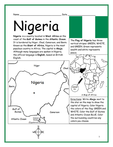
Introduce your students to Nigeria with this printable handout of two worksheets (plus answer key). Your students will read a brief introduction to Nigeria (location, capital, flag, language), write ‘Abuja’ next to the star on the map to show the capital, color the small map, and use the map and compass to answer 8 questions on page 2. Colored pencils and a pen or pencil are needed for this activity. Basic Geography worksheet includes a simple map to introduce the country of Nigeria and practice cardinal/ordinal directions.
For use with Interactive Notebooks: After the worksheets are completed, students can cut out the map and flag and paste into the notebook under the topic of Africa / Sub-topic: Nigeria. Under the map and flag, your students can write a summary in their own words of what they now know about this country. Collect worksheets for other countries of Africa to add to the notebook! Please see this store for a selection of printable worksheets for other countries of Africa (and beyond!).
Thank you so much for using my Geography worksheets in your classroom! I hope you find them useful. Reviews are welcome and very much appreciated!
Introduce your students to the country of Slovenia in Europe with two worksheets (plus answer key). Your students will read a brief introduction to Slovenia (location, capital, flag, language), write Ljubljana next to the star on the map to show the location of the capital, color the small map, and use the map and compass to answer 9 questions on page 2. Colored pencils and a pen or pencil are needed for this activity. No other prep needed. Basic Geography worksheet with a simple map to introduce Slovenia and practice cardinal and ordinal directions.
For use with Interactive Notebooks: After completing the worksheets, students can cut out the map and flag and paste into the notebook under the topic of Europe/Sub-Topic: Slovenia. Under the map and flag, students can write a summary in their own words of what they now know about this country. Collect worksheets for other countries of Europe to add to the notebook! Please browse this store for a list of worksheets for other countries of Europe (and beyond!).
Thank you so much for using my Geography worksheets in your classroom! I hope you find them useful. Reviews are welcome and very much appreciated!
Introduce your students to Ethiopia with two worksheets (plus answer key). Your students will read a brief introduction to Ethiopia (location, capital, flag, language), write ‘Addis Ababa’ next to the star on the map to show the location of the capital, color the small map, and use the map and compass to answer 8 questions on page 2. Colored pencils and a pen or pencil are needed for this activity. No other prep needed. Basic Geography worksheet includes a simple map to introduce the country of Ethiopia and practice cardinal/ordinal directions.
For use with Interactive Notebooks: After the worksheets are completed, students can cut out the map and flag and paste into the notebook under the topic of Africa / Sub-topic: Ethiopia. Under the map and flag, your students can write a summary in their own words of what they now know about Ethiopia. Collect worksheets for other countries of Africa to add to the notebook! Please browse this store for worksheets for other countries of Africa (and beyond!).
Thank you so much for using my Geography worksheets in your classroom! I hope you find them useful. Reviews are welcome and very much appreciated!
Introduce your learners to MADAGASCAR in Africa with two worksheets (plus answer key). Your students will read a brief introduction to Madagascar (location, capital, flag, language), write ‘Antananarivo’ next to the star on the map to show the location of the capital, color the small map, and use the map and compass to answer 6 multiple-choice questions on page 2. Colored pencils and a pen or pencil are needed for this activity. No other prep needed. Basic Geography worksheet with a simple map to introduce the country of Madagascar and practice cardinal/ordinal directions.
For use with Interactive Notebooks: After the worksheets are completed, students can cut out the map and flag and paste into the notebook under the topic of Africa / Sub-topic: Madagascar. Under the map and flag, your students can write a summary in their own words of what they now know about this country. Collect worksheets for other countries of Africa to add to the notebook! All available in this store!
Thank you so much for using my Geography worksheets in your classroom! I hope you find them useful. Reviews are welcome and very much appreciated! Please browse this store for worksheets to introduce your learners to all countries of Africa and the world!
Introduce your students to the 7 continents with this printable handout of 2 worksheets (plus answer key). Your students will write the name of each continent on the map: Africa, Antarctica, Asia, Europe, North America, Oceania (Australia), and South America, trace the line of the equator, color the small map, and use the map and compass to answer 7 questions. Colored pencils and a pen or pencil are needed for this activity. No other prep needed. Basic geography worksheet with a simple map to introduce the continents and practice cardinal and ordinal directions.
For use with Interactive Notebooks: After the handout is completed, students can cut out the map of the 7 continents and paste into the notebook. Under the map, students can write a summary in their own words of what they now know about the continents. Collect handouts for countries of Africa, Antarctica, Asia, Europe, North America, Oceania/Australia, and South America to add to the notebook! Please browse this store for a selection of printable handouts.
Thank you so much for using my Geography worksheets in your classroom! I hope you find them useful!
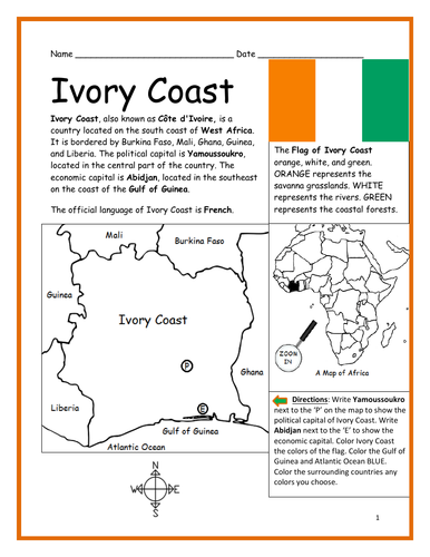
Introduce your learners to IVORY COAST (Côte d’Ivoire) in Africa with two worksheets (plus answer key). Your students will read a brief introduction to Ivory Coast (location, capital, flag, language), write ‘Yamoussoukro’ next to the ‘P’ on the map to show the political capital of Ivory Coast, write ‘Abidjan’ next to the ‘E’ to show the economic capital, color the small map, and use the map and compass to answer 9 questions on page 2. Colored pencils and a pen or pencil are needed for this activity. No other prep needed. Basic Geography worksheet with a simple map to introduce Ivory Coast and practice cardinal and ordinal directions.
For use with Interactive Notebooks: After the worksheets are completed, students can cut out the map and flag and paste into the notebook under the topic of Africa/Sub-topic: Ivory Coast. Under the map and flag, students can write a summary in their own words of what they now know about this country. Collect worksheets for other countries of Africa to add to the notebook! Please browse this store for a selection of worksheets for other countries of Africa (and beyond!).
Thank you so much for using my worksheets in your classroom! Reviews are welcome and very much appreciated!
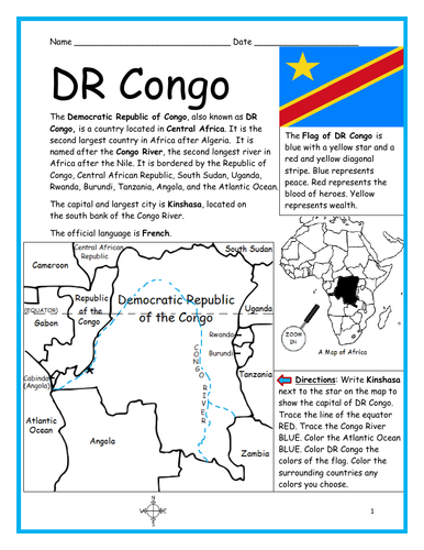
Introduce your students to the Democratic Republic of Congo (DR Congo) with this printable handout of two worksheets (plus answer key). Your students will read a brief introduction to DR Congo (location, capital, flag, language), write ‘Kinshasa’ next to the star on the map to show the capital, trace the lines to show the location of the equator and Congo River, color the small map, and use the map and compass to answer 9 questions on page 2. Colored pencils and a pen or pencil are needed for this activity. No other prep needed. Basic Geography worksheet with a simple map to introduce DR Congo and practice cardinal and ordinal directions.
For use with Interactive Notebooks: After the worksheets are completed, students can cut out the map and flag and paste into the notebook under the topic of Africa/Sub-topic: DR Congo. Under the map and flag, your students can write a summary in their own words of what they now know about this country. Collect handouts for other countries of Africa to add to the notebook! Please browse this store for a selection of printable worksheets for other countries of Africa (and beyond!).
Thank you so much for using my Geography worksheets in your classroom! I hope you find them useful! Reviews are welcome and very much appreciated!
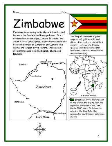
Introduce your students to ZIMBABWE in Africa with this printable handout of two worksheets (plus answer key). Your students will read a brief introduction to Zimbabwe (location, capital, flag, language), write ‘Harare’ next to the star on the map to show the capital, color the small map, and use the map and compass to answer 9 questions on page 2. Colored pencils and a pen or pencil are needed for this activity. No other prep needed. Basic Geography worksheet includes a simple map to introduce the country of Zimbabwe and practice cardinal/ordinal directions.
For use with Interactive Notebooks: After the worksheets are completed, students can cut out the map and flag and paste into the notebook under the topic of Africa/Sub-topic: Zimbabwe. Under the map and flag, your students can write a summary in their own words of what they now know about this country. Collect handouts for other countries of Africa to add to the notebook! Please browse this store for a selection of printable handouts for other countries of Africa (and beyond!).
Thank you so much for using my Geography worksheets in your classroom!
Included in resource: Lake Kariba, Zambezi River, Limpopo River, South Africa, Botswana, Zambia, Mozambique.
Resource Room
Introduce your students to CHAD with two worksheets (plus answer key). Your students will read a brief introduction to Chad (location, capital, flag, language), write ‘N’Djamena’ next to the star on the map to show the location of the capital, color the small map, and use the map and compass to answer 9 questions on page 2. Colored pencils and a pen or pencil are needed for this activity. No other prep needed. Basic Geography worksheet with a simple map to introduce the country of Chad and practice cardinal/ordinal directions.
For use with Interactive Notebooks: After the worksheets are completed, students can cut out the map and flag and paste into the notebook under the topic of Africa/Sub-topic: Chad. Under the map and flag, your students can write a summary in their own words of what they now know about this country. Collect worksheets for other countries of Africa to add to the notebook! Please browse this store for a selection of worksheets for all other countries of Africa (and beyond!).
Thank you so much for using my Geography worksheets in your classroom! I hope you find them useful. Reviews are welcome and very much appreciated.
Introduce your students to SOMALIA in Africa with this printable handout of two worksheets (plus answer key). Your students will read a brief introduction to Somalia (location, capital, flag, language), write ‘Mogadishu’ next to the star on the map to show the capital, trace the line of the equator, color the small map, and use the map and compass to answer 9 questions on page 2. Colored pencils and a pen or pencil are needed for this activity. No other prep needed. Basic Geography worksheet includes a simple map to introduce Somalia and practice cardinal/ordinal directions.
For use with Interactive Notebooks: After the worksheets are completed, students can cut out the map and flag and paste into the notebook under the topic of Africa/Sub-topic: Somalia (or Horn of Africa). Under the map and flag, your students can write a summary in their own words of what they now know about this country. Collect handouts for other countries of Africa to add to the notebook! Please browse this store for a selection of printable handouts for other countries of Africa (and beyond!).
Thank you for using my Geography worksheets in your classroom! I hope you find them useful. Reviews are welcome and very much appreciated!
Included on map: Horn of Africa, Ethiopia, Djibouti, Kenya, Gulf of Aden, Somali Sea, Indian Ocean, Equator
Introduce your students to the SOUTHEAST REGION of the United States with this printable handout of one page (plus answer key). Using the map of the Southeast Region, find the twelve states in the word search puzzle: Virginia, North Carolina, South Carolina, Georgia, Florida, Alabama, Arkansas, Kentucky, Louisiana, Mississippi, Tennessee, West Virginia.
Handouts also available for other regions! Please check out this store for:
-SOUTHWEST REGION MAP AND WORD SEARCH
-NORTHEAST REGION MAP AND WORD SEARCH
-MIDWEST REGION MAP AND WORD SEARCH
-WEST REGION MAP AND WORD SEARCH
Thank you so much for using my Geography worksheets in your classroom!
Introduce your students to the country of Australia with this printable handout of two worksheets (plus answer key). Your students will read a brief overview of Australia (location, capital, flag), write ‘Canberra’ next to the star on the map to show the capital, color the small map, and use the map and compass to answer 6 questions on page 2. Colored pencils and a pen or pencil are needed for this activity. Basic Geography worksheet with a simple map to introduce the country of Australia and practice cardinal and ordinal directions.
For use with Interactive Notebooks: After the handout is completed, students can cut out the map and flag of Australia and paste into the notebook. Under the map and flag, students can write a summary in their own words of what they now know about this country. Collect handouts for other countries to add to the notebook. Please browse this store for a selection of printable Geography worksheets!
Thank you so much for using my Geography worksheets in your classroom!
Included: Indian Ocean, Pacific Ocean, Sydney, Melbourne, Brisbane, Perth, Adelaide.
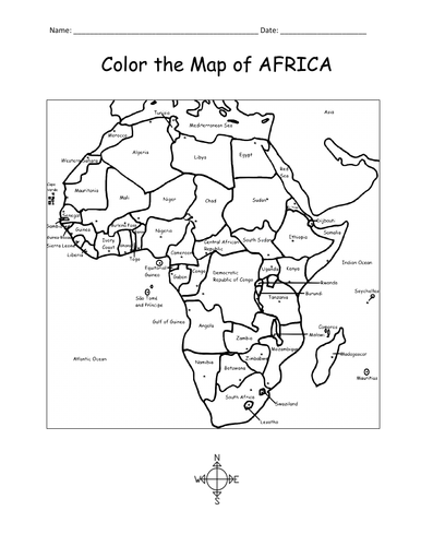
Print and color the map of Africa! This printable coloring sheet of one page includes the 54 countries of Africa to color and learn.
Thank you so much for using my Geography worksheets and coloring pages. Please browse this store for a selection of printable worksheets for countries of Africa and beyond!
Color and learn the map of Asia with this printable coloring page. Colored pencils or crayons are needed for this activity. No other prep needed.
Countries included: Afghanistan, Armenia, Azerbaijan, Bahrain, Bangladesh, Bhutan, Brunei, Cambodia, China, Cyprus, Georgia, India, Indonesia, Iran, Iraq, Israel, Japan, Jordan, Kazakhstan, Kuwait, Kyrgyzstan, Laos, Lebanon, Malaysia, Maldives, Mongolia, Myanmar, Nepal, North Korea, Oman, Pakistan, Palestine, Philippines, Qatar, Russia, Saudi Arabia, Singapore, South Korea, Sri Lanka, Syria, Taiwan, Tajikistan, Thailand, Timor-Leste, Turkey, Turkmenistan, UAE (United Arab Emirates) , Uzbekistan, Vietnam, and Yemen. Also the Arctic Ocean, Pacific Ocean, Indian Ocean and surrounding parts of Europe and Africa.
Thank you for using my Geography worksheets and coloring pages!
Introduce your learners to the GREAT LAKES of North America with this printable handout of two worksheets (plus answer key). Your students will write the names of the 5 Great Lakes on the map, color the map (Great Lakes, Canada, United States) and use the map to answer 9 questions on page 2.
Included on this map: Lake Superior; Lake Michigan; Lake Huron; Lake Erie; Lake Ontario; Canada Provinces Ontario and Quebec; US States: Minnesota; Wisconsin; Iowa; Illinois; Indiana; Michigan; Ohio; Pennsylvania; New York.
Thank you for using my Geography worksheets! Please browse this store for a selection of printable Geography worksheets for North America and beyond.
The United Arab Emirates consists of 7 emirates. Using the map of UAE, find the 7 emirates in this word search puzzle! 7 emirates include: Abu Dhabi, Ajman, Dubai, Fujairah, Ras al Khaimah, Sharjah, Umm al Quwain. 1 printable word search puzzle (plus answer key).
Thank you so much for using my printable worksheets in your classroom! Reviews are welcome and very much appreciated. Please browse this store for more Word Search Puzzles and Geography worksheets!
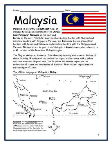
Introduce your learners to the country of Malaysia in Southeast Asia with this printable handout of two worksheets (plus answer key). Your students will read a brief overview of Malaysia (location, capital, language, flag), write ‘Kuala Lumpur’ next to the star on the map to show the location of the capital, color the small map, and use the map and compass to answer 8 questions on page 2. Colored pencils and a pen or pencil are needed for this activity. No other prep needed. Basic Geography worksheet with a simple map to introduce Malaysia.
For use with Interactive Notebooks: After your students complete the worksheets, they can cut out the map and flag of Malaysia and paste into the notebook under the topic of Asia / Sub-topic: Malaysia. Under the map, students can write a summary in their own words of what they now know about this country. Collect worksheets for other countries of Asia to add to the notebook! Please browse this store for a selection of printable worksheets for other countries of Asia (and beyond!).
Thank you so much for using my Geography worksheets in your classroom! Reviews are welcome and very much appreciated.
Included: China Sea, Malay, Peninsular Malaysia, Borneo’s East Malaysia, Thailand, Singapore, Vietnam, Indonesia, Brunei, Philippines, Vietnam. Stripes of Glory. Jalur Gemilang.
Introduce your learners to the country of CAMBODIA in Southeast Asia with this printable or digital handout of two worksheets (plus answer key). Your students will read a brief overview of Cambodia (location, capital, language, flag), write ‘Phnom Penh’ next to the star on the map to show the capital, trace the lines of the Tonle Sap and Mekong River, color the small map, and use the map and compass to answer 8 true/false questions on page 2. Colored pencils and a pen or pencil are needed for this activity. No other prep needed. Basic Geography worksheet with a simple map to introduce Cambodia and practice cardinal and ordinal directions.
For use with Interactive Notebooks: After your students complete the worksheets, they can cut out the map and flag of Cambodia and paste into the notebook under the topic of Asia / Sub-topic: Cambodia. Under the map, students can write a summary in their own words of what they now know about this country. Collect worksheets for other countries of Asia to add to the notebook! Please browse this store for a selection of printable worksheets for other countries of Asia (and beyond!)
Thank you so much for using my Geography worksheets in your classroom! Reviews are welcome and very much appreciated.
Included: Thailand, Laos, Vietnam, Buddhism, Angkor Wat, Khmer, Mekong River
Introduce your learners to the island country of JAMAICA with this printable handout of 2 worksheets (plus answer key). Your students will read a brief introduction to Jamaica (location, capital, flag), write ‘Kingston’ next to the star on the map to show the location of the capital, color the maps, and use the maps and compass to answer 10 true/false questions on page 2. Colored pencils and a pen or pencil are needed for this activity. No other prep needed. Basic Geography worksheet with simple maps to introduce the country of Jamaica and practice cardinal and ordinal directions.
For use with Interactive Notebooks: After the worksheets are completed, students can cut out the map and flag and paste into the notebook (under the topic of the Caribbean or West Indies or Greater Antilles / Sub-topic: Jamaica). Under the map, your students can write a summary in their own words of what they now know about this country. Collect worksheets of other countries to add to the notebook! Please browse this store for a selection of worksheets for other countries of the Caribbean (and beyond!).
Thank you so much for using my Geography worksheets in your classroom! Reviews are welcome and very much appreciated.
Caribbean Sea, Cuba, Hispaniola, Dominican Republic, Haiti, Cayman Islands, Montego Bay, Negril, Port Antonio, Blue Mountain, Blue Mountain Peak.