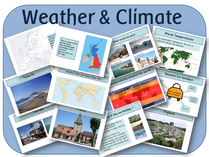
Hero image

404Uploads

1033k+Views

667k+Downloads

Mountains display pack
highwaystarhighwaystar

Mountains display pack

(0)
This resource contains headings, vocabulary and posters, all in pdf format on CD to print out for a Mountains display MOUNTAINS LETTERING - This lettering is to cut out for display. 'MOUNTAINS' / 'THE MOUNTAIN ENVIRONMENT' is written out, which can either be printed as a banner, or cut out for display. There are also all upper and lower case letters and numbers included so that you can print out whatever you need to personalise your display. THE MOUNTAIN ENVIRONMENT A4 HEADER - to print. MOUNTAINS VOCABULARY DISPLAY - With headings and photographs (2 per A4 sheet - Includes blizzard, avalanche, snowdrift, snow, hail stones, snow flake, alpine glow, flood, peak, mountain range, base station, mountain tourism, ski run, litter, mountain, hill, flora and fauna.) MOUNTAINS POSTERS - 15 A4 sheets, with explanations and descriptions: What is a mountain? Plate tectonics (x2) Fold mountains Fault-block mountains Volcanic mountains Dome mountains Plateau mountains Mountain climates Mountain temperatures Mountain weather Mountain rainfall Mountain ranges - map Seven Summits - map UK mountains - map
Tocuaro & Mexico - Powerpoint lessons, worksheets and activities
highwaystarhighwaystar

Tocuaro & Mexico - Powerpoint lessons, worksheets and activities

(0)
A set of geography resources looking at where Tocuaro is and what it is like there. POWERPOINTS Tocuaro mind map: For the beginning of the topic, to record what the children already know. Where is Tocuaro?: Shows the location of Tocuaro, in relation to the UK, Europe, and the rest of the world. What is Tocuaro like?: Photographs of life in and around Tocuaro, for the children to look at to find information. What is it like to live in Tocuaro?: Photographs of a Mexican family, different types of jobs and activities, food, dining, school, and traditional costumes. Is life in Mexico similar to life in the UK?: Photographs showing different aspects of life in Tocuaro and Mexico - street scenes; church; market stalls; crafts; houses; children; high street; washing clothes, and cooking. PRINTABLE RESOURCES (PDF) How to get to Tocuaro: A world map for the children to draw a route from their home town to Mexico. What is it like in Tocuaro: Three versions for different abilities - to write down what they think Tocuaro is like. Similarities and Differences: Worksheet for writing lists of similarities and differences. Mask template x 3: For the children to design their own mask.
Volcanoes - display resources
highwaystarhighwaystar

Volcanoes - display resources

(0)
A set of pdf files for display: Volcano Vocabulary - Includes volcano terminology, an explanation, and a picture for each of the following: ash' bomb; caldera; cinder cone; crater; crust; eruption; fault; geothermal; lava; lava dome; lava flow; mud flow; phreatic eruption; plate tectonics; plug; pyroclastic flow; Ring of Fire; Strombolian eruption; vent. Volcano word mat - To support the children in their work, contains pictures and vocabulary. Parts of a volcano diagram - A labelled picture of all the different parts of a volcano. Label parts of the volcano - 2 versions for the children to label. Title - Prints onto an A4 sheet. Banners - 2 versions, each prints onto 2 A4 sheets. A-Z lettering - Contains 'Volcanoes' lettering, plus all the letters of the alphabet, lower and upper case. Volcanic Explosivity Index - Information table to print, detailing how eruptions are measured.
Seaside holidays (history and geography) - PowerPoint lessons and worksheets
highwaystarhighwaystar

Seaside holidays (history and geography) - PowerPoint lessons and worksheets

(0)
A set of powerpoint lessons looking at the history and geography of seaside holidays, plus activities, worksheets and display resources. POWERPOINTS Seaside mind map: For AfL Seaside introduction: Looks at why we go to the seaside, and how it differs from other places. It shows pictures of the countryside, town, and seaside, asking children to point out the differences. What is the seaside like?: Looks at photographs to explore the human and physical features of coastal locations When do we go on holiday and what do we see?: Looks at the different times of year we have school holidays, and how they coincide with religious festivals. It shows photographs of different objects and activities at modern seaside resorts. Seaside in the past: 18 seaside photographs from 1880 until the 2000s. The children are asked to talk about what they see in each picture. Human and physical features: A study of Blackpool, with photographs and maps, to explore the key human and physical features of the resort. The children can match features they see in photographs to a map. There are also links to British seaside tourist websites. Looking at aerial photographs: Eight seaside locations to look for human and physical features. How has the seaside changed?: Six pictures of seasides in the past to look at and discuss. Pictures of seasides in the past: Six pictures of seasides in the past to look at and discuss. The Victorian seaside: A look at how seaside resorts developed, and why people in Victorian times enjoyed going to the seaside. It looks at the different things that children did at the seaside, and compares them to what children do today. ACTIVITIES: Acrostic poem Aerial photographs of different seaside locations showing pictures of coastal locations around the UK Playing cards Colouring pictures My favourite environment worksheet Packing list: Ready to go on holiday My seaside holiday with seaside border, to write a description Passport of places visited to itemise and describe where they have been Passport: A blank passport to fill in Postcard; blank to fill in Stamps to use on the postcards Seaside border paper for writing Seaside holidays in the past: Compare 2 pictures to see how things were different in the past. Seaside pictures past and present: For activities such as ordering events, describing, comparing etc Survey – places visited: For a class survey Topic covers x 4: With ‘The Seaside’ / ‘Seaside Holidays’ headings Town country seaside description: To describe the different areas UK jigsaw: England, Northern Ireland, Scotland and Wales UK map: To mark out places visited What can you find at the seaside: For making a list What can you see? Pictures of the town, seaside and countryside to describe Plus lots more!
Investigating airports and planes KS1 flight transport topic lessons and worksheets
highwaystarhighwaystar

Investigating airports and planes KS1 flight transport topic lessons and worksheets

(0)
A unit of work with 3 PowerPoint lessons, investigating air transport, visiting the airport and flying on a plane; plus 23 worksheets. LESSONS: INTRODUCTION TO FLIGHT: Looks at maps of the UK, Europe, USA and the world - encouraging children to discuss which modes of transport would be suitable for getting to different places. Introduces flying as the best kind of transport for travelling to places far away. (17 slides) THE AIRPORT: A look at different things that are seen when travelling through the aiport, with pictures, descriptions and explanations. Explains the airport terminal, inside and outside; checking in; check in desk; baggage; baggage handlers; boarding card/QR scan; security; departure lounge; information boards; departure gates; boarding the plane; the runway; air traffic control and luggage carousel. (30 slides) AEROPLANES: Explores different parts of a plane - the flight deck, engines, wings, flaps and spoilers, fuel, fuselage, the tail and wheels; plus the inside of the plane - the cabin, doors, overhead bins, seats, safety cards, flight attendants, windows, galley, food and toilet. (35 slides) WORKSHEETS: 23 worksheets including - Labelling airport signs Making a passport Writing a postcard Describe the aiport pictures Label parts of a plane Maps of the world, Europe, the USA and the UK A place I would like to visit Plus A-Z lettering with airport picture background 3 pages of airport colour clipart Writing border sheets Some of the PowerPoints include a linked video to watch. This is a link shared through SafeShare TV - a programme that filters adverts and unwanted advertising from the clip. You may need to check if you can access this in school. The links were checked before uploading, but if any don’t work, feel free to contact me and I will update them.
The Titanic - powerpoint lessons, worksheets and activities suitable for KS1 KS2
highwaystarhighwaystar

The Titanic - powerpoint lessons, worksheets and activities suitable for KS1 KS2

(0)
This is a set of 6 PowerPoint lessons and printable worksheets; suitable for teaching children aged 7-11 PowerPoint lessons: TITANIC INTRODUCTION A page for recording what the children already know, and a brief outline of the 1900’s, the Titanic, and her maiden journey. BUILDING THE TITANIC Who built and designed the Titanic and where it was built. ON BOARD THE TITANIC A 28 page PowerPoint, looking at who was on board - the crew, the different classes of passengers, and what each class was like, and what the Titanic was like inside. TITANIC’S MAIDEN VOYAGE A 30 page PowerPoint, telling the story of the Titanic’s fateful maiden voyage. It includes an explanation of how icebergs travel to the Atlantic Ocean, and looks at some survivors and what happened to the victims of the disaster. TIMELINE OF THE VOYAGE A detailed step by step report of the events of the Titanic’s maiden voyage. FINDING THE TITANIC Looks at how the Titanic was rediscovered in 1985, and what has happened to her since. Includes pictures and artefacts from the wreck. PDF FILES : BLANK MAP: For the children to map out the route the Titanic took WHAT I ALREADY KNOW ABOUT THE TITANIC: sheet for the children to record what they already know and what they would like to learn WRITING SHEET: For creative writing NEWSPAPER REPORT: For report writing SEQUENCING: Images for sequencing the story
Geography topic: Coasts - powerpoint lessons and activities
highwaystarhighwaystar

Geography topic: Coasts - powerpoint lessons and activities

(0)
A set of lessons and worksheets looking at coasts, erosion, deposition and tourism. POWERPOINTS INTRODUCING COASTS: Introduction to what coasts are; erosion and deposition, and investigating different coastal localities around the UK. COASTAL EROSION: Looks at different physical features caused by wave erosion - arches, caves and coastal stacks, and demonstrates the process of erosion by animated diagrams of how each feature is formed. It also briefly explains how different rock types erode at different rates, and shows a map of the UK, with the main types of rock found in each area. It ends with a series of photographs for the children to look at and identify coastal features. COASTAL DEPOSITION: Investigates the process of longshore drift, with an animated example, and explains the difference between sand and shingle beaches. INVESTIGATING COASTAL ENVIRONMENTS: Gives the children the task of writing a piece about a different coastal location for a holiday brochure. MANAGING THE COASTLINE: Explores how coastal erosion affects humans, and the reasons why we need to protect the coast from erosion. It explains how we protect the coast by building groynes, sea walls, armour, artificial harbours, or how we can just do nothing - giving the advantages and disadvantages of each method of protection. COASTAL DEVELOPMENT: Gives the children the task of being a local resident, a sea angler, a travel company representative, a holidaymaker, or a local government official, and deciding whether a hotel should be built in an unspoilt area of coastline. WORKSHEETS (PDF) LABEL COASTAL AREAS ON UK MAP: A blank UK map for the children to identify coastal areas that they know. COASTAL EROSION: 2 pictures of coastal erosion for children to name features and describe the formation WORLD AND UK MAP: To locate coastal areas in the world that they have visited BROCHURE TEMPLATES: 10 different blank layouts for the children to fill in for the holiday brochure. COASTAL DEVELOPMENT GROUP WORKSHEETS: Recording sheets when the children split into different groups to decide on whether a hotel should be built.
Portugal powerpoint and headings
highwaystarhighwaystar

Portugal powerpoint and headings

(2)
The powerpoint covers the following: Where is Portugal?: With maps showing the location of Portugal. What is Portugal like?: Images of Portugal; different geographical features Living in Portugal: Pictures of everyday life in Portugal - streets, shops, schools, houses etc. Portuguese people: What life is like in Portugal - culture, traditional dress, language etc The history of Portugal: a brief history from Roman times to present.
KS2 Geography: Weather and climate zones around the world topic - powerpoints and activities
highwaystarhighwaystar

KS2 Geography: Weather and climate zones around the world topic - powerpoints and activities

(0)
A set of resources looking at holidays and world climate zones. It contains 5 PowerPoint lessons to use on an interactive whiteboard, and 4 pdf activities to print out. POWERPOINTS: Holidays: Where have we been on holiday; why do people go on holiday, with photo prompts, maps and explanations World Climates: Description of Tropical, Temperate and Polar climates, where they are in the world, and a brief explanation why. Planning a holiday: Description of 4 people to plan a holiday for. Links to online resources. Country Research: Links to good websites for the children to research. What do we need to pack: 4 locations for the children to look at and pack for. PDF FILES My packing list - to fit in with the PowerPoint file. Printable world map - for the children to plan their holiday route. Postcard - Blank postcard for the children to write. Passport of places visited - for the children to fill in at the end of the topic.
The Rainforest - powerpoint lessons and activities
highwaystarhighwaystar

The Rainforest - powerpoint lessons and activities

(0)
Series of lessons looking at where the rainforests of the world are, what they are like, their climate, flora and fauna, with a case study of the Amazon Rainforest. INTERACTIVE WHITEBOARD RESOURCES (POWERPOINTS) Rainforest introduction: A beginning to the topic, asking what children already know. It shows where all the world’s rainforests are located on a map, and describes the four main areas where rainforests grow. It explains the definitions of a tropical rainforest, and how it differs from a temperate rainforest. It ends with questions. Rainforest climate: Explains the difference between climate and weather, and looks at world climate zones, and what they are called. It describes temperature, rainfall and humidity in tropical rainforests. Rainforest plants: Looks at, and explains the different layers that grow in a rainforest. It explains plant adaptations, with questions on how different plants have adapted to living in the rainforest. Natural resources in the rainforest: Looks at the different natural resources that are found in rainforest areas, such as palm oil, wood, the cacao tree, the rubber tree, and medicines. It explains their uses in a global society. Saving the rainforest: Explores all the different reasons why the rainforest is disappearing - logging, settlement, agriculture, cattle rearing, road building, and extraction of natural resources. Discusses why it is important to save the rainforests, and what could happen if they disappear. It looks at different viewpoints - governments, companies, inhabitants, and the global community. It explains what is being done to save the rainforests, and what we can do to help. The Amazon Rainforest: Locates the Amazon Rainforest, river, and basin on maps, and shows the different countries that the Amazon rainforest spans. Looks at the history of the rainforest, the people who live there, and the animals. Explains interdependence, and how important plants and animals in the rainforest are to each other. It explains the current threats to the rainforest, and why it is so important to the rest of the world. PRINTABLE WORKSHEETS (PDF) Locating the rainforests: A blank world map, for the children to locate the rainforests. Rainforest layers: Drawing of the layers in the forest for the children to label and describe.
The Arctic: ( animals and Ocean) powerpoint,display, worksheets and activities
highwaystarhighwaystar

The Arctic: ( animals and Ocean) powerpoint,display, worksheets and activities

(0)
A set of printable resources (display, worksheets, games and activities) plus a PowerPoint about the Arctic, the Arctic Ocean and animals in the Arctic. The set contains: The Arctic PowerPoint. It covers: What is the weather like in the Arctic? Where is the Arctic? What is the Arctic Circle? The North Pole What plants grow in the Arctic Circle What animals live in the Arctic Circle - herbivores and predators Arctic birds Arctic whales Arctic sea animals Humans and the Arctic 2 A4 headings Alphabet polar bears Anagram worksheet - Arctic animals A-Z lettering with an snowy background; all letters of the alphabet, plus numbers and punctuation, plus ‘The Arctic’ in large letters Bookmarks to cut out and colour, with polar bears Display border - with pictures of polar bears Cards - Arctic animals for games or display Factfile sheets - for children to research and fill in Flags - The countries bordering the Arctic Circle Map showing satellite imagery of the Arctic Circle A map of the Arctic Circle Masks - black and white animals from the Arctic Number line to 20 with digits and written numbers with a polar bear background Passport to fill in for a trip to the Arctic Pictures of Arctic animals to cut out and use in topic work Pictures of Arctic animals to print out for display Postcard to write from the Arctic Set of posters with explanations and photographs of: The location of the Arctic Arctic plants The Inuit Arctic animals Polar bear Wolverine Arctic fox Arctic owl Arctic tern Snow geese Arctic hare Arctic squirrel Lemming Seal Muscox Caribou Walrus Topic covers - 3 different versions Vocabulary cards - Arctic adjectives for composition Writing border sheets - lined and unlined
Year 3 Science topic pack
highwaystarhighwaystar

Year 3 Science topic pack

5 Resources
This set contains resources for the 5 different science topics in Y3. The resources include powerpoint lessons, worksheets, display and outline planning documents.
Volcanoes: KS2 Natural disasters - powerpoint lessons
highwaystarhighwaystar

Volcanoes: KS2 Natural disasters - powerpoint lessons

(0)
Detailed explanations of how volcanoes are formed, how they erupt and where they are found, plus a case study of the 2010/2011 eruptions in Iceland. What are volcanoes? - Includes a historical background to the name volcano; explains what a volcano is; what they release; what they are like; what happens in an eruption; can they be predicted; and volcano facts. How and why volcanoes erupt - An explanation of: where magma comes from; tectonic plates; divergent and convergent plate boundaries; hot spots; and location of the world's volcanoes. Volcano classification - Identifies and explains the different ways in which volcanoes can be classified - Type of lava (runny or thick); Type of volcanic eruption (Hawaiian, Strombolian, Vulcanian, Pelean, or Plinian); Shape of volcano (focusing on just 2 types - Shield volcano, stratovolcano / composite, plus talks about under water volcanoes); and whether they are active, dormant or extinct. Volcano glossary - Explanations and pictures of vocabulary relating to volcanoes (Magma chamber, vent, conduit, flank, cone, lava flow, pyroclastic flow, ash cloud, volcanic bomb, crater, caldera) Living near a volcano - Looks at the reasons why people live near or on volcanoes, and asks the children to think about what hazards there could be. Are there volcanoes in Britain? - A brief explanation of volcanic activity in Britain, and examples of extinct volcanoes in England, Scotland, Wales and Ireland. Volcano questions - 11 photographs of volcanoes and their effects, with questions. Make a volcano - instructions for making an eruption
The Inuit - powerpoint and heading
highwaystarhighwaystar

The Inuit - powerpoint and heading

(0)
The powerpoint covers the following: Who are the Inuit? Traditional Inuit homes Modern Inuit homes Modern villages Traditional Clothing Modern Inuit Clothing Inuit food Inuit art Inuit tools Seals Fish Hunting Whales Language Inuit travel - on land and sea
KS1 Geography and History of the United Kingdom: powerpoints and activities pack
highwaystarhighwaystar

KS1 Geography and History of the United Kingdom: powerpoints and activities pack

(1)
A set of resources for KS1 to teach children about the geography, history and culture of the UK. GEOGRAPHY POWERPOINT LESSONS Geography of the UK: ENGLAND Geography of the UK: SCOTLAND Geography of the UK: WALES Geography of the UK: NORTHERN IRELAND Each powerpoint is approximately 20 pages long and includes information on: The location of the country in the world and in the UK The names of the ocean and surrounding seas The capital city Information on the capital city and key landmarks Islands Mountains Rivers Specific features such as castles, brochs, lochs, stone circles etc. Myths and Legends Traditions HISTORY POWERPOINTS HISTORY OF THE UK: A quick look through different periods in the history of the United Kingdom; how the UK has been invaded and settled, why places are as they are, and how the countries got their names. THE UNION FLAG: The story of how it came into being. It includes: Flag of England; Saint George, the story of St George and the Dragon, the St George's Cross The Flag of Wales The Flag of Scotland; St Andrew, the story of King Angus MacFergus The Flag of Britain, 1606 The Flag of the Protectorate; including the arms of Ireland Great Britain; the ensign armorial, 1707 St Patrick's Cross; the story of St Patrick The Union Flag Jacks How to draw the Union Flag THE NATIONAL ANTHEM THE ROYAL COAT OF ARMS: Explains what a coat of arms is and how they are created. Explains about the Royal coat of arms today. ACTIVITIES AND WORKSHEETS: Factfiles x 4: For fact finding missions, cities, rivers, mountains and a blank one. They contain boxes for text, lines for explanations and a blank map of the UK. Flag activities: 6 different flag sheets Map of UK Topic cover Jigsaw of the UK Simple outline plan in word with links and suggestions.
Huge Christmas pack - cards,  colouring, display, activities and powerpoints
highwaystarhighwaystar

Huge Christmas pack - cards, colouring, display, activities and powerpoints

(0)
A bumper set of interactive whiteboard, display and printable crafts and activities, suitable for KS1 or lower KS2. The pack includes: CHRISTMAS / NATIVITY POWERPOINTS: 5 Little Reindeer Can you solve the problems for Santa - 15 problem solving questions (Suitable for Y1, but you could adapt it for other years) Christmas around the World - How Christmas is celebrated in 12 other countries Christmas Carols - Words for Silent Night; The First Noel; We Three Kings; Away in a Manger Christmas Songs - Words for Frosty the Snowman; Jingle Bells; Must be Santa; Rudolph the red-nosed reindeer; We wish you a Merry Christmas Christmas Facts - Interesting facts about Christmas Jingle Bells - The song The Nativity Story The Three Kings poem Twinkle Twinkle Winter Poetry Who wants to be a millionaire Christmas quiz CHRISTMAS HEADINGS: The Three Wise Men / Christmas / The Nativity A-Z LETTERING - Includes all upper and lower cases, numbers and punctuation. Baubles / Christmas / Reindeer / Snowflake / Snowmen / Christmas Stockings. NATIVITY WORD MAT Contains 27 words with accompanying pictures CHRISTMAS CARDS: A set of 12 different designs for the children to colour, paint or decorate. Each card contains ‘Merry Christmas’ lettering, which can be coloured in; and a black and white image of either: Three Wise men / Baby Jesus / Baubles / Bells / Reindeer / Santa / Star / Stocking / Tree /Tree and doves / Tree scene. All you need to do is print them out and let the children choose a design CHRISTMAS ACTIVITIES: A range of Christmas activities to make and do ACTIVITES: Christmas Alphabet / Christmas code breaker / Christmas tree poem / Christmas wordsearch - 3 different versions. FOR MAKING LISTS: Santa list x3 versions / Santa beard list / Santa star list / Tree list FOR WRITING A LETTER TO SANTA: Santa letter 1 / Santa letter 2 A4 WRITING SHEETS: Christmas border / Elves and lights border / Santa border / Star border / Stocking border PRINTABLE COLOURING ACTIVITIES: Christmas colouring - 13 various pictures / Nativity colouring - 12 pictures / Elves colouring - 7 pictures / Snowmen colouring - 6 pictures / Reindeer colouring - 7 pictures / Santa colouring - 10 pictures / Plus 7 assorted sheets with accompanying title to colour.
Mountains KS2 geography topic - powerpoint lessons
highwaystarhighwaystar

Mountains KS2 geography topic - powerpoint lessons

(0)
A pack of powerpoints and printable maps- includes mountain facts, climates, tourism, mountain environments, and the 7 continent summits. POWERPOINTS What and Where are mountain environments An introduction to the topic, showing photographs of different environments for the children to identify physical features. Introduces mountains, and mountain ranges; and locates the main areas on a world map. Mountains in the UK Shows a map of different mountain ranges in the UK, and gives a description of the 4 highest mountains in Scotland, Wales, England and Northern Ireland. It ends with a task. Mountain areas of the world Shows the location of the main mountainous areas in each continent and describes the Seven Continent Summits in a fact-file style. It ends with a task.