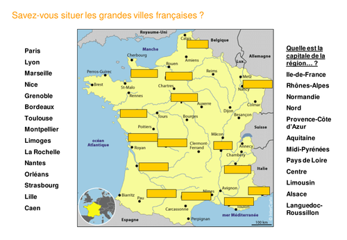

I have designed this Powerpoint for a comprehensive lesson on French geography with A Level and IB students. The aim is to learn about key aspects of France in preparation for their exam.
The presentation consists of 11 maps of France representing different aspects of France : climate, economy, landscapes, counties, regions, rivers and…wine among others! There is also an interactive slide with the main French cities and regions to place correctly on the map. It is followed by other slides illustrating various regions of France . My students found it very useful to revise and reinforce their knowledge of the French territory.
I can be used as a cross-curricular activity with Geography.
Something went wrong, please try again later.
Lots of detailed maps, has saved me hours, thank you! Just needs updating with current regions, and possibly more recent statistics.
Report this resourceto let us know if it violates our terms and conditions.
Our customer service team will review your report and will be in touch.
£3.00