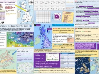
AQA GCSE Geography paper 3 pre-release support for 2024.
Tudeley Village development.
This document contains 12 pages of resources that can be set as homework to run along the pre-release booklet or taught in class.
Includes:
Exemplar answer to a question that could possibly be similar to the 9 mark question this summer. Last year’s prediction was correct as well as for 2022.
Task sheet to help student to examine the pre-release booklet.
Additional suggested questions to practice.
Now updated due to the change in the map provided by AQA.
TRY BEFORE YOU BUY:** FREE LESSON** FROM THE SOW below:
https://www.tes.com/teaching-resource/geography-weather-lesson-beast-from-the-east-ks3-12742521
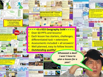
Get this Scheme of work with 5 other KS3 Geography Schemes of work in my shop for just £12.99! includes all of my KS3 resources!
https://www.tes.com/teaching-resource/all-of-my-ks3-resources-12842783
Or it get it as part of a bundle of 3 SoW about UK weather, UK rivers and UK landscapes for just £6.89
https://www.tes.com/teaching-resource/3-ks3-geography-full-sow-23-lessons-rivers-weather-and-climate-and-uk-lanndscapes-12742210
A 9 lesson fully resourced SoW as well as an assessment lesson. All lessons include titles and objectives, geographical skills and knowledge, engaging and well planned tasks. This SoW fits any curriculum for KS3 and is of observation quality.
Lesson 1: What is weather and climate?
Lesson 2: Recording the Weather
Lesson 3: Who cares about the weather?
Lesson 4: Where does the UK’s weather come from?
Lesson 5: The Beast from the East
Lesson 6: How can the UK use it’s wind?
Lesson 7: Does the UK need so much rain?
Lesson 8: What are Urban Micro climates and how do they affect London?
Lesson 9: Assessment and feedback
The SoW is easy to understand and teach with prompts and answers on screen for all tasks, encourages use of all geographical skills like map work, graph skills, data use, debating, photo analysis and more. This will save hours of planning time and will be enjoyed by teacher and students alike.
Please check out all of my FREE school resources and Geography lessons on my shop where you´ll also find full schemes of work for just £3 and lots of other useful resources… Or purchase all of my KS3 resources for just £12.99!
I would really appreciate it if you could leave me a review, thanks!
https://www.tes.com/teaching-resources/shop/ukjoshkelly94
Questions or issues: ukjoshkelly@yahoo.co.uk
GET ALL OF MY PAID KS3 RESOURCES FOR JUST £12.99!!!
75+ lessons for under £13 or less than 10p a lesson… Bargain!
**Seven Key Stage 3 Schemes of work, enough teaching content for almost two years! **
All of my lessons are well planned, engaging, differentiated and fun! Download one of my free ones if you aren´t sure and try before you buy!
The following Schemes of work are included WITH assessments:
*** World biomes (11 lessons)**
• Lesson 1: Ecosystems
• Lesson 2: Food webs
• Lesson 3: Global biomes introduction
• Lesson 4: Mediterranean biome
• Lesson 5: Coral Reefs
• Lesson 6: Bamboo forests
• Lesson 7: Tropical Rainforests
• Lesson 8: Hot deserts
• Lesson 9: Polar biomes
• Lesson 10: Assessment lesson
• Lesson 11: Peer feedback/marking lesson
River landscapes of the UK (7 lessons)
• Lesson 1: Where are the UK’s rivers?
• Lesson 2: What are the UK’s rivers like?
• Lesson 3: What processes happen inside a river?
• Lesson 4: How do waterfalls form?
• Lesson 5: Meanders… they’re forever changing
• Lesson 6: The Landforms of the Lower Course
• Lesson 7: The Somerset levels floods 2014
• Lesson 8: How can we our manage rivers?
• Lesson 9: Rivers Assessment lesson
*** Weather and climate of the UK (9 lessons)***
• Lesson 1: What is weather and climate?
• Lesson 2: Recording the Weather
• Lesson 3: Who cares about the weather?
• Lesson 4: Where does the UK’s weather come from?
• Lesson 5: The Beast from the East
• Lesson 6: How can the UK use it’s wind?
• Lesson 7: Does the UK need so much rain?
• Lesson 8: What are Urban Micro climates and how do they affect London?
• Lesson 9: Assessment and feedback
Tropical Rainforests (12 lessons)
• Lesson 1: What and where are our rainforests?
• Lesson 2: What is the structure of the Rainforests?
• Lesson 3: What is the climate like in the Rainforest?
• Lesson 4: How are plants and animals adapted to the rainforest?
• Lesson 5: How do we benefit from the Rainforest?
• Lesson 6: What is Deforestation?
• Lesson 7: What are the effects of Deforestation?
• Lesson 8: How can we use the rainforest sustainably?
• Lesson 9: Saving the Rainforest!
• Lesson 10: Assessment lesson
• Lesson 11: Assessment feedback and peer marking lesson.
• Lesson 12: Extended project: Researching a rainforest.
*** UK landscapes and processes (7 lessons) **
• Lesson 1: introduction to UK landscapes
• Lesson 2: How does geology shape the UK?
• Lesson 3: Chemical weathering and limestone plateaus
• Lesson 4: Mountains in the UK: Their birth and erosion
• Lesson 5: Forests in the UK
• Lesson 6: Map reading and tourist developments in the lake district.
• Lesson 7: Assessment lesson with feedback PPT.
Hot deserts (9 lessons)
Lesson 1: What is a hot desert and where are they found?
Lesson 2: Drawing a climate graph for hot deserts
Lesson 3: How can animals and plants survive in hot deserts?
Lesson 4: What is desertification and why is it happening?
Lesson 5: Can desertification be stopped?
Lesson 6: Tourism in a hot desert far far away…
Lesson 7: Can you navigate through a hot desert?
Lesson 8: Assessment lesson
Lesson 9: Peer marking and assessment feedback
**Globalisation 12 lessons: **
Lesson 1: An introduction to globalisation
Lesson 2: How has globalisation happned?
Lesson 3: Why do companies go global? Mcdonalds
Lesson 4: What is a TNC and why do they work in so many countries?
Lesson 5: The pros and cons of globalisation
Lesson 6: The dark side of globalisation
Lesson 7: A TNC in Nigeria: Shell
Lesson 8: How is globalisation helpful? NGOs
Lesson 9: IGOs: WHO will stop Malaria?
Lesson 10: Assessment lesson
Lesson 11: Peer marking and assessment feedback
Lesson 12: Optional project on a TNC
extras!
This includes ALL of my lessons, quizzes, and six full schemes of work with over 75 lessons in total!!!
(some stand alone lessons are omitted as they are repeated/included in SoW)
Please check out all of my FREE school resources and Geography lessons on my shop where you´ll also find full schemes of work for just £3 and lots of other useful resources… Or purchase all of my KS3 resources for just £12.99!
I would really appreciate it if you could leave me a review, thanks!
https://www.tes.com/teaching-resources/shop/ukjoshkelly94
Questions or issues: ukjoshkelly@yahoo.co.uk
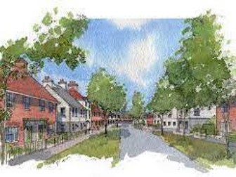
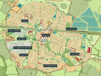
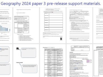
Mock exam to accompany 2024 Geography Pre-Release Booklet for Paper 3. This also includes the Mark Scheme too.
The issue being examined is the England housing crisis/urban sprawl/sustainable settlements with the proposal of Tudeley Village.
There is also another mock exam and mark scheme which can be found under my resources.
https://www.tes.com/teaching-resource/gcse-aqa-paper-3-pre-release-2024-mock-exam-and-mark-scheme-1-geography-tudeley-village-13000591
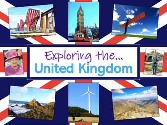
Exploring the UK is a Geography unit suitable for KS1 and lower KS2 (Y2-4).
The planning overview, topic title page and vocabulary page can be downloaded for free here. Lessons include:
L1 – Identifying the countries and capitals of the UK & Ireland (FREE)
L2 – Locating UK cities using compass directions
L3 – Identifying human & physical features of the UK
L4 – Investigating satellite photos of the UK
L5 – Comparing the city and the countryside
L6– Identifying famous features and characteristics of countries of the UK
L7 – Identifying flags of the United Kingdom
L8 – Identifying the four seasons of weather in the UK
Optional lesson – Identifying the countries and capital cities of Europe
Each lesson includes a presentation and differentiated activities/worksheets.
If you like this resource, we would appreciate a review! We will happily send you a free resource in return for a review or useful suggestions/feedback. Contact us at ed@teachitforward.co.uk.
AQA A Level Geography- Contemporary Urban Environments
Lessons include the following content: Urban form, world cities, Urban waste, Urban Climate, precipitation and drainage, megacities, Air quality and river restoration.
Discussion and research tasks which engage students about current issues in our cities- UK and global.
Key case studies include: Birmingham and Mumbai (social and environmental sustainability and regeneration) and the Cheonggyecheon River Restoration Project in Seoul. Emphasis on current global challenges and solutions to them.
Exam questions embedded and structured in most lesson to ensure progress is made towards the exams.
Any questions, please ask.
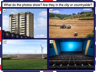
This lesson is part of Exploring the United Kingdom, a Geography unit designed for KS1 and lower KS2 (Y2-4).
This lesson encourages students to identify geographical features found in the city/countryside and think about the similarities and differences between urban and rural areas in the UK.
First the presentation shows small segments of images from around the United Kingdom and challenges students to work out whether they are from the city or countryside.
Children then complete a Venn diagram-based activity which can be done in two ways:
Group activity:
In pairs or trios, children sort images of the city and countryside using a Venn diagram. This can also be done using two PE hoops and makes a nice classroom display.
Individual activity:
Students sort city and countryside vocabulary using a Venn diagram:
Easier – Students sort 12 city/countryside words
Harder – Students sort 18 city/countryside words
If you like this resource, we would appreciate a review! We will happily send you a free resource in return for a review or useful suggestions/feedback. Contact us at ed@teachitforward.co.uk.
Changes in British farming lesson plan, PowerPoint and worksheets.
There is a PDF of all of the files and an editable version of each file (you just need to delete the watermark logo from each of the editable files).
You can find more KS1 Geography lesson plans, worksheets and teaching resources on the Save Teachers’ Sundays website.
Note: This lesson was updated on 21st August 2020. Please download the most recent version of it if you bought it before this date. Please also use the lesson plans that are not in the ‘Combined’ file.
105 lessons for IGCSE geography themes 1, 2 and 3. All lesson are suitable for 50 minutes to 1 hour of teaching time. Includes supporting worksheets for lessons - no additional resources are required.
Population:
1 - Introduction to population
2 - Malthus vs Boserup
3 - Migration
4 - The demographic transition model
5 - Anti-natalist policy, the one-child policy
6 - Over vs underpopulation
7 - Cause of migration
8 - Voluntary vs forced migration - refugees
9 - Ageing population
10 - Population structure
11 - Youthful population
12 - Dense vs sparse population
13 - Jelly baby population
Settlement:
1 - Settlement provision
2 - Settlement structure
3 - Settlement services
4 - Rural settlement service provision
5 - Urban settlement service provision
6 - Burgess model and the CBD
7 - Green and brownfield sites
8 - Problems in urban areas
9 - Manchester
10 - Urban regeneration
11 -Urbanisation
12 - Impacts of urbanisation
13 - Squatter settlements
14 - Squatter settlement case study - Dharavi
Earthquakes and Volcanoes
1 - What are hazards?
2 - Structure of the earth
3 - Types of volcano
4 - Why live in hazardous areas?
5 - Volcano case study
6 - Earthquakes
7 - Disaster response in Haiti
8 - Disaster response in New Zealand
Rivers:
1 - Hydrological cycle and drainage basins
2 - Erosion and deposition
3 - Landforms in the upper course
4 - Landforms in the middle course
5 - Landforms in the lower course
6 - Flooding
7 - Hard and soft engineering
8 - Rivers case study - Somerset
9 - Rivers GIS
Coasts:
1 - Waves
2 - Coastal processes
3 - Landforms processes
4 - Erosional landforms
5 - Depositional landforms
6 - Coral reefs
7 - Threats to coral reefs
8 - Mangroves
9 - Hard and soft engineering
10 - Coastal case study
11 - Assessment
Weather:
1 - Atmospheric circulation
2 - Measuring the weather
3 - Clouds
Climate and Natural Vegetation
1 - Climate zones
2 - Hot deserts
3 - Climate graphs and deserts
4 - Ecosystems
5 - Rainforests
6 - Soil and biodiversity
7 - Opportunities in hot deserts
8 - Causes of deforestation
9 - Impacts of deforestation
10 - Managing the rainforest
11 - Desertification
12 - Sustainable management of the world
Development
1 - Development indicators
2 - Industry
3 - Globalisation
4 - TNCs
5 - TNC case study
6 - Trade game
Food production
1 - Introduction to agriculture
2 - Food shortages
3 - Food supply and shortages (1)
4 - Food supply and shortages (2)
5 -Food production (Indus Valley)
6 - Famine (Horn of Africa)
Industry
1 - Industrial systems
2 - Types of industry
3 - Industrial zones case study
Tourism
1 - Growth of tourism
2 - Pros and cons of tourism growth
3 - Eco tourism
4 - Tourism case study (Jamaica)
Energy
1 - Growing consumption
2 - Non-renewable energy
3 - Renewable energy
4 - Fuelwood and other energy
5 - Nuclear energy
6 - Hydro-electric power case study
7 - Increasing energy
Water
1 - Water supply and use
2 - Water stress
3 - Water management
4 - Lesotho Highland project
Environmental Risk of Development
1 - Soil fertility and threats
2 - Deferestification
3 - Climate change and the enhanced greenhouse effect
4 - Managing the environment
5 - Conserving the environment
For more resources visit This is Geography. Full SoW for all new GCSE specifications - AQA, Edexcel, OCR, CIE IGCSE, Edexcel IGCSE and Eduqas. As well as over 200 lessons for KS3 and KS2. Want something bespoke designing? Email us for further details info@thisisgeography.co.uk
This lesson is part of a wider Geography unit called Great Missenden – A Village Settlement which is designed for students in upper KS2 (Y4-6).
The presentation introduces students to the concept of settlements and asks them to categorise them by size (e.g. hamlet, village, town, city, conurbation). It then introduces them to a range of human geographical features found in settlements (e.g. post offices, sports stadiums).
In the activity students identify a variety of human geographical features found in settlements. It is differentiated two ways:
Easier – Students identify the features of settlements with normal clues.
Harder – Students identify the features of settlements with jumbled up clues.
Extension – Students identify which types of settlements these features are usually found in.
If you like this resource, we would appreciate a review! We will happily send you a free resource in return for a review or useful suggestions/feedback. Contact us at ed@teachitforward.co.uk.
A fully resourced and up to date lesson on aid, introduction to different types of aid, when do we use it and how the UK gives aid to Pakistan
Task 1: Starter - Answer true and false questions about previous learning
Task 2: Define aid then writing the definition on their worksheet
Task 3: Read through the different facts about aid in Pakistan and students are to outline if the facts are positives of negatives to Pakistan
Task 4: Main Task - Long form writing- students to define what aid is, how it can benefit and be a negative to Pakistan. Then they are to state overall if aid is a good or bad thing and justify if the UK should keep giving aid.
Task 5: Plenary - On whiteboards, students to give ideas on how Pakistan can improve development in their country.
**Download contains PowerPoint and worksheet for the lesson. **
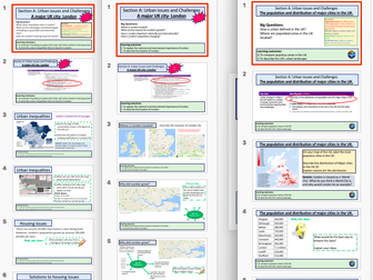
Lessons for the 'Urban Challenges in the UK' section of the new AQA 9-1 Spec. All worksheets for lessons are included as slides at the end of each PPT.
5 Lessons included:
*The UK's distribution of population and major cities
*London CS - Where is London, What is London's population and ethnic mix?
*London CS - What is social deprivation, is it an issue in London? Housing issues, greenfield and brownfield sites, does the green belt solve the issues?
*London CS - Pollution, Waste management and Urban greening.
*London CS - Regeneration Shorditch and Docklands
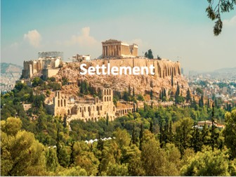
Full unit of work for Settlement. This unit explores the evolution of settlements in the UK and across the world. All lesson are suitable for 50 minutes to 1 hour of teaching time. Includes supporting worksheets for lessons - no additional resources are required. Most suitable for KS3 or high ability KS2.
All lessons have a starter and lesson aim. All PowerPoints in the same signature style.
Lesson sequence:
1 – What is a settlement?
2 – Settlement functions
3 – Site, situation and settlement patterns
4 – Why do settlements change?
5 – Burgess and Hoyt model
6 – Changes in retail
7 – Favelas
8 – Changing London and the effect of the Olympics
9 – GIS and settlement change – A comparison of the UK and Brazil
10 – Brownfield vs Greenfield sites
Also includes Geography Literacy mat and Geography Numeracy/Map Skills mat.
For more resources visit This is Geography. Full SoW for all new GCSE specifications - AQA, Edexcel, OCR, CIE IGCSE, Edexcel IGCSE and Eduqas. As well as over 200 lessons for KS3 and KS2. Want something bespoke designing? Email us for further details info@thisisgeography.co.uk
Map of UK with coordinates. Could be used for history, geography, maths or topic lessons.
Also in my resources, a map of the world with coordinates added.
Children could be asked to find a city and record the coordinates.
Children could be asked which city is in each set of coordinates.
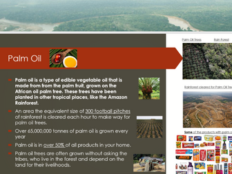
Devised from the Key Stage 2 Geograhy Currciulum, the Power Point explores four key trade links which occour in rainforests (specifically the amazon). Palm Oil - Logging - Cattle and Medicines.
Their is also a slide on Fair Trade and two final slides where children can have a debate on the advantages and disadvantages for specific groups of people - Meeting a key Geography Skill.
LI: To understand the impact of human geography on the rainforest and environmental issues caused by this. (Key Knowledge)
LI: To explain opinions from a range of different points of view. (Key Skill)
There is an Information gathering sheet, which children can stick into their book and answers as they go through the PowerPoint.
The Majority of my Year 6s will do this task independently with the sheet and the PowerPoint
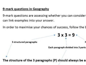
A simple, structured and proven way of getting your students to understand what it takes to perform well in 9-mark questions. Can be used as a stand alone lesson in preparation for assessments or as a reflection activity. Technique is guaranteed to improve student scores if applied. In Trial exam experiments, high achievers improved by 1.5 marks on average after being taught this technique and low achievers improved by an average of 1 mark. For students that used the technique, the improvement was 2.5 marks for high achievers and 2 marks for low achievers.
9-mark example answer to work through following the guidance page on technique with tasks (identify the parts of the answer and correct spellings). Space for students to attempt their own answer to a different questions with sentence starters.
Lesson plan attached.
A quick worksheet where children can match map symbols to their meanings. Makes a good starter for a Geography lessons using ordnance survey (OS) maps.
Following their personal choices in session 1, children research the countries they identified. They mark physical features on their maps, including rivers, lakes, deserts and mountains. They also identify the oceans and seas.
Suitable for years 5 and 6.
These classroom activities work to explore how international trade can both help and hinder people in developing countries as they try to improve their lives. Through real-life examples, pupils are encouraged to consider the notion of ‘fairness’ and think about the positive impact of buying products that have been fairly traded upon the lives of people in developing countries.
 Quick View