Sea Level Rise in the Maldives and East England
PowerPoint and resources to be used for AQA A - Rising Sea Levels.
A comparison of the impacts of sea level rise on both the Maldives and the UK. Pupils can annotate facts around a map of the Maldives, create a table of the social, economic, environmental and political impacts of SLR. Pupils can use the ripple diagram, to identify, global, regional and local scale impacts. Compare to the issues that could result if sea levels rise in East England, and answer an exam style question with mark scheme.
 Quick View
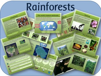
The Rainforest - powerpoint lessons and activities
Series of lessons looking at where the rainforests of the world are, what they are like, their climate, flora and fauna, with a case study of the Amazon Rainforest.
INTERACTIVE WHITEBOARD RESOURCES (POWERPOINTS)
Rainforest introduction: A beginning to the topic, asking what children already know. It shows where all the world’s rainforests are located on a map, and describes the four main areas where rainforests grow. It explains the definitions of a tropical rainforest, and how it differs from a temperate rainforest. It ends with questions.
Rainforest climate: Explains the difference between climate and weather, and looks at world climate zones, and what they are called. It describes temperature, rainfall and humidity in tropical rainforests.
Rainforest plants: Looks at, and explains the different layers that grow in a rainforest. It explains plant adaptations, with questions on how different plants have adapted to living in the rainforest.
Natural resources in the rainforest: Looks at the different natural resources that are found in rainforest areas, such as palm oil, wood, the cacao tree, the rubber tree, and medicines. It explains their uses in a global society.
Saving the rainforest: Explores all the different reasons why the rainforest is disappearing - logging, settlement, agriculture, cattle rearing, road building, and extraction of natural resources. Discusses why it is important to save the rainforests, and what could happen if they disappear. It looks at different viewpoints - governments, companies, inhabitants, and the global community. It explains what is being done to save the rainforests, and what we can do to help.
The Amazon Rainforest: Locates the Amazon Rainforest, river, and basin on maps, and shows the different countries that the Amazon rainforest spans. Looks at the history of the rainforest, the people who live there, and the animals. Explains interdependence, and how important plants and animals in the rainforest are to each other. It explains the current threats to the rainforest, and why it is so important to the rest of the world.
PRINTABLE WORKSHEETS (PDF)
Locating the rainforests: A blank world map, for the children to locate the rainforests.
Rainforest layers: Drawing of the layers in the forest for the children to label and describe.
Extreme living around the world
Power Point Presentation on the worlds most extreme places to live including the hottest, coldest, wettest.
Highest highway, tallest waterfall and extreme houses included.
Weather - Scheme of work, whole unit
Geography unit of work for KS3
Lessons include:
L1 - Introduction to weather/How does weather impact the lives of people
L2 - Measuring Weather
L3 - Rainfall and Clouds (Includes Videos)
L4 - Why is our weather so changeable
L5 and 6 - Boscastle Floods
L7 - Climate and Climate Graphs
L8 - Factors that influence Climate
L9 - Assessment - Attached.
All lessons include PowerPoint. Worksheets are also available. Assessment also available.
undefined
Lesson 3 - China's Climate
To start students decide what it is like to live in China?
They use photograph to show what they think best represent the climate in China and give reasons why. Students are introduced to a climate graph, showing them temperature and rainfall in a city or country. Students are then to complete a small exam Question: Describe what the climate in Beijing is like. They use the climate graph to help them with this and then can peer assess their partners answer. Students are then to complete a living graph. They decide where 9 statements ‘best’ fit on the climate graph and write the statements around the graph then draw an arrow to the place that you think it belongs to. An extension task of giving reasons "Where did you put your statements and why?" can be completed. Finally students are to compare Beijing’s to London’s - showing the difference in the type of weather they/we get at different times of the year.
WEATHER BOXES
Activities and resources for different types of weather. Great to have ready to use whatever the weather.
How are humans increasing the greenhouse effect
This lesson focusses on the effect that humans are having on teh greenhosue effect.
They are also shown how the greenhouse effect works and then have an exam practise question to do.
comparing hot and cold weather/climate
3 worksheets differentiated for la/ma/ha
chn cut and stick or draw items to pack for a hot and cold country
Tourism in the Arctic
A lesson designed to teach students about the various tourist activities in the Arctic and the potential positive or negative impacts this may have on the area. I used this lesson with a low mixed ability year 7 class.
The lesson contains differentiated resources and a structured homework task (to design a postcard for the Arctic).
Sale
Travel Guide Writing based on the NEW Geography Curriculum N/SAmerica Study and NEW English KPIs
2 Resources to support a personal study on a US state, supporting the NEW Geography KS2 Curriculum.
1. An example Travel Guide Text based on the USA State of Montana. Aimed at higher end of expected level.
2. A planning format for students to plan each paragraph of own chosen US State (North America/South America)
Students can research chosen state during lessons or for homework using planning frame.
Meets many of the NEW English reading and writing KPIs
- parenthesis, managing clause structures and manipulating for effect.
End of Unit AfL task for Global Warming and Climate Change
An open-ended assessment task for pupils who have recently studied global warming. The task focuses on the effects and consequences of global warming rather than the causes, but also includes an extension activity requiring pupils to consider how the process of global warming may be stopped or slowed down.
Suitable for KS3 and KS4 geography
The resource is provided with two levels of differentiated support and also includes teacher's notes.
Carbon offsetting and storage lesson
A lesson designed to teach students about possible solutions to increasing CO2 levels, specifically offsetting and storage. This was used in an observation lesson with a year ten environmental science class.
The lesson includes differentiation for higher and foundation abilities, independent learning, collaborative working, progress checks, modelled answers and peer assessment. The resources are very detailed.
Flooding
a range of activities that could be used as a round robin exercise on flooding in the uk, and flood defences, the pictures at the end could be used as a way of assessing progress each pupils has one on the board that they can move along at the completion of a task
Snow Day or Winter Theme 10 Activity Pack. Engaging and Educational Full Colour Worksheets
This pack is perfect if you are snowed in at school or just need some wintery work to keep your class occupied. Contains 10 fun and educational activities that are highly creative and will keep your class busy for hours. Contains colour worksheets including English activities, artistic activities, research activities and topical learning to do with the cold! Suitable for individual or partner work and can be used with either KS1 and KS2.
Hurricane Katrina DME (Tropical Storms)
I have just started teaching tropical storms and I wanted to do a DME with my students. I couldn't find any good resources out there so I have created one myself based on Hurricane Katrina. The lesson is called "Can you save New Orleans from Katrina?".
Many of you will have seen the DME based on the Montserrat eruption. I have used the basis for that DME to create this lesson. It involves a series of events being revealed on the board. In group's of 4 they must make decisions about the management of New Orleans for an impending disaster (Katrina). They are given 3 options and must write down the information about the event as well as which decision they make. Students are given an A3 map of the Gulf of Mexico and must track the tropical storm and annotate as much information as possible. Students are also given a flood map of New Orleans; information appears about flooding in New Orleans due to the storm surge, which students must add to the map and complete the key.
At the end of the lesson, 10 points are given for every decision they get correct (in line with what really happened). The correct decision (worth 10 points) can be found in italics below the corresponding event on the word document. 20 bonus points are available for the accuracy of the two maps, which is up to the teacher to award whilst students answer the plenary questions (10 points maximum per map).
I think this is a really nice lesson. It worked very well with my students and got them engaged in what is a very challenging topic. The idea is that students make better decisions than the government officials made and make comparisons between their own plan and what really happened.
I have spent hours making the resources and hope you like them. All information and data is accurate as I spent a lot of time researching and corresponding the correct response to the accurate time period.
Earthquakes Full SoW
Comprehensive Scheme of Work about Earthquakes, their effects and how they affect people. Written for Y8/9 EBSD boys. I use promethean and if you look at my planning there are hyperlinks to stuff too.
 Quick View
Desertification
Comprehensive KS3 desertification lesson
Includes tasks, homework and video framework
Originally designed as part of an Extreme Environments UOW, available for £8 on the This is Geography shop
For more resources visit This is Geography. Full SoW for all new GCSE specifications - AQA, Edexcel, OCR, CIE IGCSE, Edexcel IGCSE and Eduqas. As well as over 200 lessons for KS3 and KS2. Want something bespoke designing? Email us for further details info@thisisgeography.co.uk
 Quick View
Extreme tourism - Antarctica
This lesson explores extreme tourism in Antarctica. Suitable for GCSE Human Geography.
For more resources visit This is Geography. Full SoW for all new GCSE specifications - AQA, Edexcel, OCR, CIE IGCSE, Edexcel IGCSE and Eduqas. As well as over 200 lessons for KS3 and KS2. Want something bespoke designing? Email us for further details info@thisisgeography.co.uk
 Quick View
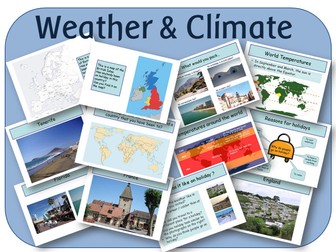
KS2 Geography: Weather and climate zones around the world topic - powerpoints and activities
A set of resources looking at holidays and world climate zones. It contains 5 PowerPoint lessons to use on an interactive whiteboard, and 4 pdf activities to print out.
POWERPOINTS:
Holidays: Where have we been on holiday; why do people go on holiday, with photo prompts, maps and explanations
World Climates: Description of Tropical, Temperate and Polar climates, where they are in the world, and a brief explanation why.
Planning a holiday: Description of 4 people to plan a holiday for. Links to online resources.
Country Research: Links to good websites for the children to research.
What do we need to pack: 4 locations for the children to look at and pack for.
PDF FILES
My packing list - to fit in with the PowerPoint file.
Printable world map - for the children to plan their holiday route.
Postcard - Blank postcard for the children to write.
Passport of places visited - for the children to fill in at the end of the topic.