pdf, 248.17 KB
pdf, 248.17 KB

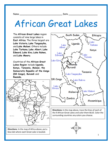
Introduce your learners to the African Great Lakes with two printable worksheets (plus answer key). Simple map activity and reading comprehension questions. Your students will read a short passage about the African Great Lakes, trace the lines of each of the 9 Great Lakes on map 1 and color the lakes and surrounding countries. The African Great Lakes include: Lake Victoria, Lake Tanganyika, Lake Malawi, Lake Turkana, Lake Albert, Lake Edward, Lake Kivu, Lake Rukwa, and Lake Mweru. On map 2, a small map of Africa, place a blue dot to show the location of each of the 9 Great Lakes, then using the maps, answer 5 multiple choice questions on page 2.

Countries of the African Great Lakes Region included on this map: Uganda, Kenya, Tanzania, Malawi, the Democratic Republic of the Congo (DR Congo), Burundi and Rwanda. Also included on map: Mozambique, Zambia, Ethiopia and South Sudan.

If you’d like to introduce your learners to the 10 COUNTRIES of the African Great Lakes region, do so one country at a time with a printable worksheet for each country! Available individually or as a discounted bundle! Please click on this link for more info: https://www.tes.com/teaching-resource/african-great-lakes-region-countries-introductory-worksheets-bundle-12777435

Thank you so much for using my Geography worksheets in your classroom! I hope you find them useful. Reviews are welcome and very much appreciated. Please browse this store for a selection of printable Geography worksheets to introduce your students to the countries of the world!

Get this resource as part of a bundle and save up to 27%

A bundle is a package of resources grouped together to teach a particular topic, or a series of lessons, in one place.

Bundle

African Great Lakes Region Countries Introductory Worksheets Bundle

Introduce your learners to the 10 countries of the African Great Lakes Region one country at a time with a printable worksheet for each country! Simple map activity and reading comprehension questions for each country. For each country, your learners will read a brief introduction (location, capital, flag, language), write the capital next to the star on the map, color the map, and use the map and compass to answer questions on page 2. Two printable worksheets plus answer key for each country. Colored pencils and a pen or pencil are needed for this activity. No other prep needed. Basic Geography worksheets with simple maps to introduce each country and practice cardinal and ordinal directions. Countries included in this bundle: Burundi, DR Congo, Ethiopia, Kenya, Malawi, Mozambique, Rwanda, Tanzania, Uganda, Zambia. *For use with Interactive Notebooks*: After the worksheets for a country are completed, students can cut out the map and flag and paste into the notebook under the topic of African Great Lakes Region / Sub-Topic: (country). Under the map and flag, students can write a summary in their own words about what they now know about this country. Add each country until the countries of the African Great Lakes Region are completed! Also included in this bundle: -African Great Lakes Introductory Worksheet -African Great Lakes - Map and Word Search Puzzle Thank you so much for using my Geography worksheets in your classroom! I hope you find them useful. Reviews are welcome and very much appreciated! Please browse this store for more printables to introduce your learners to the countries of the world!

$12.00

Reviews

Something went wrong, please try again later.

This resource hasn't been reviewed yet

To ensure quality for our reviews, only customers who have purchased this resource can review it

Report this resourceto let us know if it violates our terms and conditions.
Our customer service team will review your report and will be in touch.