Hero image

Interactive Printables

Average Rating4.56
(based on 33 reviews)

Thank you for visiting! Here you will find a selection of printable, interactive worksheets for your classroom: Basic Geography worksheets with simple maps, ESL, Spanish, Bible, Reading Comprehension and more. I hope you find the resources useful! Reviews are welcome and very much appreciated. Thank you so much.

437Uploads

338k+Views

9k+Downloads

Thank you for visiting! Here you will find a selection of printable, interactive worksheets for your classroom: Basic Geography worksheets with simple maps, ESL, Spanish, Bible, Reading Comprehension and more. I hope you find the resources useful! Reviews are welcome and very much appreciated. Thank you so much.
St Patrick's Day Printable  Handout
tspeelmantspeelman

St Patrick's Day Printable Handout

(0)
Why is St. Patrick’s Day celebrated on March 17? Why do people wear green? What are shamrocks and why do we see them everywhere on St. Patrick’s Day? Find the answers in this printable handout! Your students will read a short passage about St. Patrick’s Day and answer the questions that follow. Includes multiple-choice questions, cloze activity/fill in the blank. Two printable worksheets (plus answer key). Thank you for using my worksheets in your classroom! I hope you find them useful. Reviews are welcome and very much appreciated! Reading comprehension, vocabulary building, ESL.
BOLIVIA - Introductory Geography Worksheet
tspeelmantspeelman

BOLIVIA - Introductory Geography Worksheet

(0)
Introduce your students to Bolivia with this printable handout of two worksheets (plus answer key). Your students will read a brief overview of Bolivia (location, capital, flag, language), write 'Sucre' next to the star on the map to show the capital, color the small map and flag, and use the map and compass to answer 7 questions. Colored pencils and a pen or pencil are needed for this activity. No other prep needed. Basic Geography worksheet with a simple map to introduce Bolivia and practice cardinal and ordinal directions. For use with Interactive Notebooks: After the handout is completed, students can cut out the map and flag and paste into the notebook under the topic of South America/Sub-topic: Bolivia. Under the map, students will write a summary in their own words of what they now know about this country. Collect handouts for other countries of South America to add to the notebook! Please browse this store for a selection of printable handouts for other countries of South America (and beyond!). Thank you so much for using my Geography worksheets in your classroom!
Tales of a Fourth Grade Nothing by Judy Blume Printable worksheets for each chapter
tspeelmantspeelman

Tales of a Fourth Grade Nothing by Judy Blume Printable worksheets for each chapter

(0)
This packet includes a worksheet for each chapter of ‘Tales of a Fourth Grade Nothing’ by Judy Blume. After reading each chapter, readers can complete the worksheet/s for that chapter. Includes word search puzzles, fill-in-the-blanks, matching activities, sequencing and crosswords for reading comprehension and vocabulary building. 17 pages. Answer Key included. Worksheets are black and white (with small pictures to color as an option). Thank you for using this pack of worksheets! I hope you find them useful! Reviews are welcome and very much appreciated. If you are continuing with the Fudge series, printable worksheets for each chapter of Fudge-A-Mania are also available! Thank you again.
Map of Europe Coloring Page
tspeelmantspeelman

Map of Europe Coloring Page

(0)
Color the map of Europe. Printable handout of 1 page includes a map of Europe to color and learn. Countries of Europe included: Albania, Andorra, Armenia, Austria, Azerbaijan, Belarus, Belgium, Bosnia and Herzegovina, Bulgaria, Croatia, Cyprus, Czech Republic, Denmark, Estonia, Finland, France, Georgia, Germany, Greece, Hungary, Iceland, Ireland, Italy, Kazakhstan, Kosovo, Latvia, Lithuania, Luxembourg, Macedonia, Malta, Moldova, Monaco, Montenegro, Netherlands, Norway, Poland, Portugal, Romania, Russia, San Marino, Serbia, Slovakia, Slovenia, Spain, Sweden, Switzerland, Turkey, Ukraine, United Kingdom, Vatican City. Thank you for using my Geography worksheets in your classroom! I hope you find them useful. Reviews are welcome and very much appreciated. Please browse this store for a selection of worksheets to introduce your students to the countries of the world!
POLAND - Introductory Geography Worksheet with map and flag
tspeelmantspeelman

POLAND - Introductory Geography Worksheet with map and flag

(0)
Introduce your students to Poland with this printable handout of 2 worksheets (plus answer key). Your students will read a brief introduction to Poland (location, capital, flag, language), write 'Warsaw' next to the star on the map to show the location of the capital, color the small map and flag, and use the map and compass to answer 7 questions on page 2. Colored pencils and a pen or pencil are needed for this activity. No other prep needed. Basic Geography worksheet with a simple map to introduce Poland and practice cardinal and ordinal directions. For use with Interactive Notebooks: After the worksheets for Poland are completed, students can cut out the map and flag and paste into the notebook under the topic of Europe/Sub-Topic: Poland. Under the map, your students can write a summary in their own words of what they now know about Poland. Collect worksheets for other countries of Europe to add to the notebook! Please browse this store for worksheets for other countries of Europe - and beyond! Thank you so much for using my Geography worksheets in your classroom! I hope you find them useful and fun. Reviews are welcome and very much appreciated!
Central America - Countries and Capitals - Printable Handout
tspeelmantspeelman

Central America - Countries and Capitals - Printable Handout

(0)
Teach your students the countries of Central America with this printable handout (2 worksheets plus answer key). Students will read a brief overview of Central America, write the capital next to the star of each country, write NORTH AMERICA on the upper left side of the map and SOUTH AMERICA on the lower right, color the map, then answer the questions that follow. Colored pencils and a pen or pencil are needed for this activity. No other prep needed. This printable handout can be used after the handouts of each individual country of Central America are complete (Belize, Guatemala, Honduras, El Salvador, Nicaragua, Costa Rica, Panama) or on its own. Thank you for using my printable handouts in your classroom! I hope you find them useful. Reviews are welcome and very much appreciated.
CALIFORNIA - Introductory Geography Worksheet
tspeelmantspeelman

CALIFORNIA - Introductory Geography Worksheet

(0)
Introduce your learners to the state of California in the USA with this printable handout of two worksheets (plus answer key). Your students will read a brief introduction to California (location, capital, flag, state bird, state flower), write ‘Sacramento’ next to the star on the map to show the capital, color the small map, and use the map and compass to answer 8 questions on page 2. Colored pencils and a pen or pencil are needed for this activity. No other prep needed. Basic Geography worksheet with a simple map to introduce California and practice cardinal and ordinal directions. For use with Interactive Notebooks: After the worksheets are completed, students can cut out the map and flag of California and paste into the notebook under the topic of United States / Sub-Topic: California. Under the map, students can write a summary in their own words of what they now know about this state. Collect worksheets for states of the US and more to add to the notebook! Please browse this store for a selection of printable worksheets for other states of the USA (and beyond!). Thank you for using my Geography worksheets in your classroom! I hope you find them useful. Reviews are welcome and very much appreciated.
SOUTH AFRICA - Introductory Geography Worksheet
tspeelmantspeelman

SOUTH AFRICA - Introductory Geography Worksheet

(0)
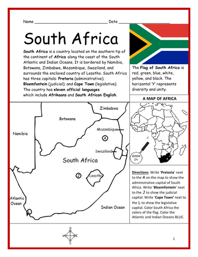
Introduce your students to the country of SOUTH AFRICA with two worksheets (plus answer key). Your students will read a brief introduction to South Africa (location, capitals, flag, language), write ‘Pretoria’ next to the ‘A’ on the map to show the administrative capital; write ‘Bloemfontein’ next to the ‘J’ to show the judicial capital; write ‘Cape Town’ next to the ‘L’ on the map to show the legislative capital, color the small map, and use the map and compass to answer 9 questions on page 2. Basic Geography Worksheet with a simple map to introduce South Africa and practice cardinal and ordinal directions. Colored pencils and a pen or pencil are needed for this activity. For use with Interactive Notebooks: After the worksheets are completed, students can cut out the map and flag and paste into the notebook under the topic of Africa / Sub-Topic: South Africa. Under the map, students can write a summary in their own words of what they now know about this country. Collect worksheets for other countries of Africa to add to the notebook! Please browse this store for a selection of worksheets for other countries of Africa (and beyond!). Thank you so much for using my Geography worksheets in your classroom! I hope you find them useful. Reviews are welcome and very much appreciated.
SPANISH SPEAKING COUNTRIES WORD SEARCH PUZZLE
tspeelmantspeelman

SPANISH SPEAKING COUNTRIES WORD SEARCH PUZZLE

(0)
Find the 21 Spanish-Speaking Countries in the Word Search Puzzle! One printable Word Search Puzzle (plus answer key). Countries to find in the Word Search Puzzle: Argentina, Bolivia, Chile, Colombia, Costa Rica, Cuba, Dominican Republic, Ecuador, El Salvador, Equatorial Guinea, Guatemala, Honduras, Mexico, Nicaragua, Panama, Paraguay, Peru, Puerto Rico, Spain Uruguay, Venezuela. Flags for each country included! Please browse this store for other worksheets to introduce your learners to the Spanish-Speaking Countries! SPANISH-SPEAKING COUNTRIES FILL IN THE BLANKS, SPANISH-SPEAKING COUNTRIES SCRAMBLE, and more! Worksheets also available to introduce your learners to each Spanish-Speaking country! Thank you so much for using my worksheets in your classroom! I hope you find them useful and fun. Reviews are welcome and very much appreciated. Please FOLLOW THIS STORE!!
SPAIN - Introductory Geography Worksheet
tspeelmantspeelman

SPAIN - Introductory Geography Worksheet

(3)
Introduce your students to Spain with two worksheets (plus answer key). Your students will read a brief introduction to Spain (location, capital, flag, language), write ‘Madrid’ next to the star on the map to show the location of the capital, color the flag and map, and use the map and compass to answer 7 questions on page 2. Colored pencils and a pen or pencil are needed for this activity. No other prep needed. Basic Geography worksheet includes a simple map to introduce Spain and practice cardinal/ordinal directions. For use with Interactive Notebooks: After completing the worksheets, students can cut out the map and flag and paste into the notebook under the topic of Europe (or Spanish-Speaking Countries), Sub-Topic: Spain. Under the map and flag, students can write a summary in their own words of what they now know about this country. Collect worksheets for other countries of Europe to add to the notebook! Please browse this store for a selection of worksheets for other countries of Europe (and beyond!). Thank you so much for using my worksheets in your classroom! I hope you find them useful. Reviews are welcome and very much appreciated.
OCEANIA Word Search Puzzle with Map
tspeelmantspeelman

OCEANIA Word Search Puzzle with Map

(0)
Using the map of the continent of Oceania, find the 14 island countries in the Word Search Puzzle. They can be found forward or backward. One printable worksheet (plus answer key). Countries included: Australia, Papua New Guinea, New Zealand, Fiji, Solomon Islands, Vanuatu, Samoa, Kiribati, Micronesia, Tonga, Marshall Islands, Palau, Tuvalu, Nauru. Thank you so much for using my Geography worksheets! I hope you find them useful. Reviews are welcome and very much appreciated. Please browse this store for more Geography worksheets and Word Search Puzzles.
ISRAEL - Introductory Geography Worksheet
tspeelmantspeelman

ISRAEL - Introductory Geography Worksheet

(0)
Introduce your students to ISRAEL with this printable handout of two worksheets (plus answer key). Your students will read a brief introduction to Israel (location, capital, flag, language), write ‘Jerusalem’ next to the star on the map to show the location of the capital, color the small map, and use the map and compass to answer 9 questions on page 2. Colored pencils and a pen or pencil are needed for this activity. No other prep needed. Basic Geography worksheet with a simple map to introduce Israel and practice cardinal/ordinal directions. For use with Interactive Notebooks: After the worksheets are completed, students can cut out the map and flag and paste into the notebook under the topic of Asia / Sub-topic: Israel. Under the map and flag, your students can write a summary in their own words of what they now know about Israel. Collect handouts for other countries of Asia to add to the notebook! Please browse this store for a selection of worksheets for all other countries of Asia (and beyond)! Thank you so much for using my Geography worksheets in your classroom! I hope you find them useful. Reviews are welcome and very much appreciated. Included: Mediterranean Sea, Red Sea, Dead Sea, Holy Land, Lebanon, Syria, Jordan, Egypt, Saudi Arabia, Tel Aviv, Bethlehem, Nazareth, Palestinian territories West Bank and Gaza, Star of David, Tallit.
ICELAND - Introductory Geography Worksheet
tspeelmantspeelman

ICELAND - Introductory Geography Worksheet

(0)
Introduce your students to ICELAND with two worksheets (plus answer key). Your students will read a brief overview of Iceland (location, capital, flag, language), write ‘Reykjavík’ next to the star on the map to show the location of the capital, color the map, and use the map and compass to answer 6 questions on page 2. Colored pencils and a pen or pencil are needed for this activity. No other prep needed. Basic Geography worksheet with a simple map to introduce Iceland and practice cardinal/ordinal directions. For use with Interactive Notebooks: After completing the worksheets, students can cut out the map and flag and paste into the notebook under the topic of Europe / Sub-Topic: Iceland. Under the map and flag, students can write a summary in their own words of what they now know about this country. Collect worksheets for other countries of Europe to add to the notebook! Please browse this store for worksheets for other countries of Europe (and beyond!). Thank you so much for using my worksheets in your classroom! I hope you find them useful. Reviews are welcome and very much appreciated!
1 Corinthians 13:4-7 Printable
tspeelmantspeelman

1 Corinthians 13:4-7 Printable

(0)
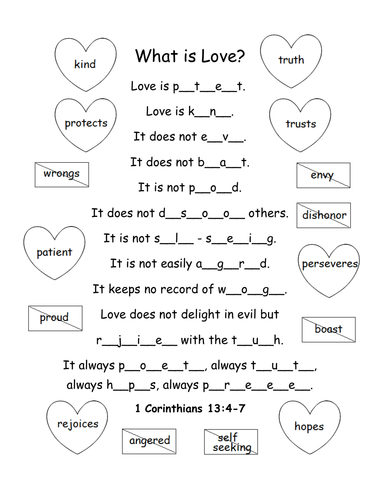
Printable activity/coloring page for 1 Corinthians 13:4-7. What is love? Fill in the blank letters for each word to complete the bible verse. Love is patient, love is kind. It does not envy, it does not boast, it is not proud. It does not dishonor others, it is not self-seeking, it is not easily angered, it keeps no record of wrongs. Love does not delight in evil but rejoices with the truth. It always protects, always trusts, always hopes, always perseveres. 1 Corinthians 13:4-7 (NIV) Thank you so much! God bless!
COUNTRY FACT SHEET BLANK PRINTABLE WORKSHEET
tspeelmantspeelman

COUNTRY FACT SHEET BLANK PRINTABLE WORKSHEET

(0)
Assign a country or have your students choose a country to learn about on their own. With this printable blank ‘Country Fact Sheet,’ your students will write the name of the assigned country, find the location of that country on the map of the 7 continents, write the country’s capital, language, president, climate, size, population, and list any other interesting facts they learned in their research. Great for homework and independent study. Thank you so much for using my printable handouts in your classroom! I hope you find them useful. Reviews are welcome and very much appreciated! Please browse this store for more worksheets to introduce your learners to the countries of the world!
COUNTRIES OF AFRICA PRINTABLE MAP AND WORD SEARCH PUZZLE
tspeelmantspeelman

COUNTRIES OF AFRICA PRINTABLE MAP AND WORD SEARCH PUZZLE

(0)
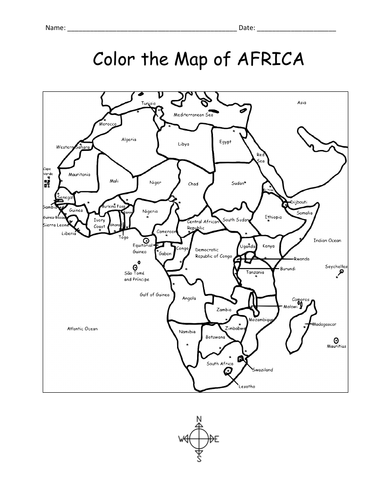
Using the map, find the 54 countries of Africa in this printable Word Search Puzzle! One printable word search puzzle with map (plus answer key). Countries to find: ALGERIA, ANGOLA, BENIN, BOTSWANA, BURKINA FASO, BURUNDI, CAMEROON, CAPE VERDE, CENTRAL AFRICAN REPUBLIC, CHAD, COMOROS, DJIBOUTI, ESWATINI, GABON, KENYA, EGYPT, EQUATORIAL GUINEA, ERITREA, ETHIOPIA, DR CONGO, CONGO, THE GAMBIA, GHANA, GUINEA, GUINEA-BISSAU, IVORY COAST, LESOTHO, LIBERIA, LIBYA, MADAGASCAR, MALAWI, MALI, MAURITANIA, MAURITIUS, MOROCCO, MOZAMBIQUE, NAMIBIA, NIGER, NIGERIA, RWANDA, SAO TOME AND PRINCIPE, SENEGAL, SEYCHELLES, SIERRA LEONE, SOMALIA, SOUTH AFRICA, SOUTH SUDAN, SUDAN, TANZANIA, TOGO, TUNISIA, UGANDA, WESTERN SAHARA, ZIMBABWE To introduce your learners to each country of Africa, please browse this store for printable worksheets! Thank you so much for using my Geography worksheets in your classroom! I hope you find them useful. Reviews are welcome and very much appreciated.
IRELAND - Introductory Geography Worksheet
tspeelmantspeelman

IRELAND - Introductory Geography Worksheet

(1)
Introduce your learners to Ireland with this printable handout of two worksheets (plus answer key). Your students will read a brief overview of Ireland (location, capital, flag, language), write ‘Dublin’ next to the star on the map to show the location of the capital, color the small map and flag, and use the map and compass to answer 6 multiple-choice questions on page 2. Colored pencils or and a pen or pencil are needed for this activity. No other prep needed. Basic Geography worksheet with a simple map to introduce the country of Ireland. For use with Interactive Notebooks: After completing the worksheets, students can cut out the map and flag and paste it into the notebook under the topic of Europe / Sub-Topic: Ireland. Under the map, students will write a summary in their own words of what they now know about this country. Collect worksheets for other countries of Europe to add to the notebook! Please browse this store for a selection of worksheets for other countries of Europe (and beyond!). Thank you so much for using my Geography worksheets in your classroom! I hope you find them useful. Reviews are welcome and very much appreciated.
Bilingual Picture Dictionary - Español e Inglés - Spanish and English
tspeelmantspeelman

Bilingual Picture Dictionary - Español e Inglés - Spanish and English

(6)
Teach Spanish and English to beginners with this printable dual-language, interactive picture dictionary. This includes 54 printable handouts with over 200 everyday, basic vocabulary words in Spanish and English with pictures to color and learn. Words are grouped into 25 topics with 6-9 pictures to color on each page, followed by a Word Review page. Teachers can cover one topic at a time. Students will save all completed handouts and staple it into a book to keep. A Cover Page, Table of Contents, and Index are included. Colored pencils or crayons are needed for this activity. No other prep needed. Topics include: English: bathroom, classroom, clothing, communication, containers, face, farm animals, foot, fruit, hand, kitchen, kitchen items, living room, nature, numbers, pets, sports, summer, table setting, tools, traffic light, transportation, vegetables, verbs, wild animals, winter. Español: el baño, el salón de clases, la ropa, comunicación, contenedores, la cara, animales de la granja, el pie, la fruta, la mano, la cocina, cosas de la cocina, la sala, la naturaleza, los numeros, mascotas, los deportes, el verano, en la mesa, herramientas, el semáforo, el transporte, las verduras, verbos – acciones, animales salvajes, el invierno Reinforce new vocabulary in Spanish and English with supplemental packets! Please click on the following links for supplemental worksheets to use with this book: VEGETABLES / LAS VERDURAS : https://www.tes.com/teaching-resource/spanish-and-english-vegetables-12005291 NUMBERS 1-10: https://www.tes.com/teaching-resource/bilingual-numbers-1-10-spanish-and-english-12014759 The supplemental packets include 7 printable worksheets to use after completing the topic with the bilingual picture dictionary. With this supplemental packet, your students will read and write each new word, match the word in English and Spanish with the correct picture, find all new words in the Word Search, Fill-in-the-Blanks, and take the quiz. Answer key included in each packet.** Thank you so much for using my worksheets in your classroom! Illustrations used with permission from Pro Lingua Associates, publisher of 'Coloring in English - A Vocabulary Builder for Beginners, by Tracy Speelman. Coloring in English includes 400 everyday, basic vocabulary words in English with pictures to color and learn: http://www.prolinguaassociates.com/ Translations by Javier Morales, Bilingual Special Education Advocate and Founder of Parents Ask - Understanding Disabilities One Question at a Time. https://parentsask.net/
Cuba - Printable Handout (British English)
tspeelmantspeelman

Cuba - Printable Handout (British English)

(0)
Teach your students about Cuba with this printable handout of 2 worksheets (plus answer key). Your students will read a brief overview of Cuba (location, capital, flag), write ‘Havana’ next to the star on the map to show the capital, then colour the flag and map of Cuba and surrounding. Then they will use the map and compass to answer 5 multiple-choice questions on page 2. Four use with Interactive Notebooks: After the handout is completed and the map and flag are coloured, cut out the map, flag and compass and paste into the notebook under the topic of CUBA. Under the map, your students will write a summary in their own words of what they now know about Cuba. Thank you four using my Geography worksheets in your classroom! Cuba and surrounding: Jamaica, Haiti, Dominican Republic, Mexico, Belize, Guatemala, Honduras, United States, Florida, the Bahamas, Caribbean Sea, Atlantic Ocean, Gulf of Mexico. North America, Central America. Cardinal, ordinal directions. Isla dae la Juventud. Note: This handout is in British English. For American English, please visit this link:
Books of the New Testament Free Printable Word Search Puzzle Activity with Bible Verse
tspeelmantspeelman

Books of the New Testament Free Printable Word Search Puzzle Activity with Bible Verse

(0)
Find each book of the New Testament in this free printable Word Search puzzle! They can be found forward or backward. Then write all remaining letters for the bible verse. Print and go! Bible verse: With God, all things are possible. Matthew 19:26 Books to find: Matthew, Mark, Luke, John, Acts, Romans, 1 Corinthians, 2 Corinthians, Galatians, Ephesians, Philippians, Colossians, 1 Thessalonians, 2 Thessalonians, 1 Timothy, 2 Timothy, Titus, Philemon, Hebrews, James, 1 Peter, 2 Peter, 1 John, 2 John, 3 John, Jude, Revelation Thank you so much for using my printables! I hope you find them useful. Please browse this store for more!!