
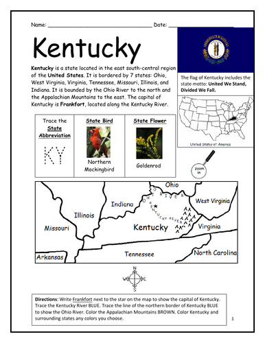
Introduce your students to the state of Kentucky with this printable handout of 2 worksheets (plus answer key). Your students will read a brief overview of Kentucky (location, capital, flag, state bird, state flower, abbreviation), write ‘Frankfort’ next to the star on the map to show the capital, trace the northern border of Kentucky blue to show the Ohio River, color a small map of Kentucky and surrounding states, and then use the map and compass to answer 10 questions on page 2. Colored pencils or crayons and a pen or pencil are needed for this activity. No other prep needed.
For use with Interactive Notebooks: After the handout is completed, students can cut out the map of Kentucky and paste into the notebook under the topic of United States / Sub-Topic: Kentucky. Under the map, your students will write a summary in their own words of what they now know about Kentucky. They can also cut and paste the state bird (Northern Cardinal), state flower (Goldenrod), and flag onto the page for Kentucky. Collect handouts for other states to add to notebook.
Thank you so much for using my Geography worksheets in your classroom! Reviews are welcome and very much appreciated.
Ordinal and cardinal directions. Kentucky borders seven states: West Virginia to the east; Virginia to the southeast; Tennessee to the south; Missouri to the west; Illinois and Indiana to the northwest; Ohio to the north and northeast. Appalachian mountains.
Something went wrong, please try again later.
This resource hasn't been reviewed yet
To ensure quality for our reviews, only customers who have purchased this resource can review it
Report this resourceto let us know if it violates our terms and conditions.
Our customer service team will review your report and will be in touch.
$1.50