


River Landforms of the Upper Course
Content:
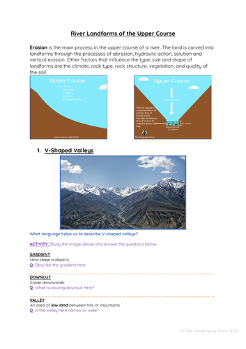
- Describes the formation of V-Shaped valleys, river rapids, potholes and waterfalls.
- Includes step-by-step descriptions supported by diagrams and key terminology.
Resources are:
FACE TO FACE READY Word Document/PDF/PowerPoint- printable resources for delivery in the classroom.
REMOTE READY Suitable for online digital learning with links to Google Docs and Google Slides that can be directly posted onto Google Classroom. Students can use digital devices to work independently on the activities from home.
Bonus Materials:
- Knowledge Organizer
- Interactive assessments (Self-marking Google Form, Keyword Quizlet, Multiple Choice Quizizz)
Each resource includes:
- Worksheet with activities.
- Teacher PowerPoint with diagrams and answer key provided directly onto the slides or in notes section of each slide.
- Activate- a starter, an introduction, a stimulus.
- Content- The Geographical knowledge- supported by short activities, images, graphs, diagrams.
- Review- a plenary, recall activity, AFL, knowledge check.
- Useful links- to video clips, websites etc.
Don’t want to purchase the full resource? CHECK OUT THE ‘MINI’ RESOURCE (Knowledge organiser and AFL activities)
What’s included:
- A word document worksheet that includes step by step descriptions of how the landforms are created. These are supported by diagrams.
- The word document is 9 pages.
- This worksheet is also provided as a PDF.
- A PowerPoint version of diagrams and answers
- The PowerPoint is 23 slides
Get this resource as part of a bundle and save up to 16%
A bundle is a package of resources grouped together to teach a particular topic, or a series of lessons, in one place.
Something went wrong, please try again later.
This resource hasn't been reviewed yet
To ensure quality for our reviews, only customers who have purchased this resource can review it
Report this resourceto let us know if it violates our terms and conditions.
Our customer service team will review your report and will be in touch.
£3.40