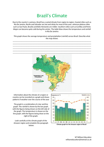
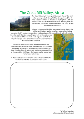
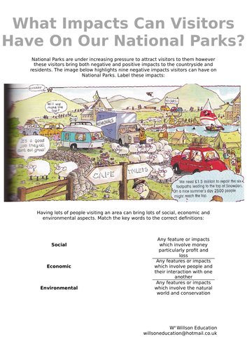
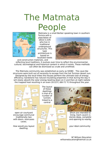
I'm a Geography teacher with experience educating at various levels, ranging from mainstream schools, SEN and extra-curricular tuition. I also have experience in teaching humanities, English and PSHE topics. My resources are designed primarily as schemes of works for mainly Geographical topics with all levels considered
The Three Gorges is a narrow, steep sided part of the Yangtze River, at five thousand kilometres one of the world’s longest rivers. The valley is home to over four hundred million people and provides over sixty per cent of Chinas rice crop.
In 1992 the Chinese government agreed to building the Three Gorges Dam. At an estimated cost of between £17 - £21 Billion and more than two kilometres long and one hundred and fifty meters high it will be the biggest dam in the world at completion in 2009.
These worksheets look at the positive and negatives of building the dam, the consiquences and leads to the opposrtunity of a class debate as to whether the Chinese government were right to build the dam.
Coastal management depends on the understanding and pulling together of the different people who use the coastline to cope with the physical processes impacting on the area. The different techniques used will have positive and negative impacts depending on their interests.
Tourism, industry, fishing, trade and transport are all land uses along the coastline but with varying interests. These worksheets helps students to understand these different interests and how they can cause problems to one another. The different types fo hard and soft enginerring techniques are discussed as well as whether they think our coastlines should be protected or left to develop naturally.
This 28 page booklet allows students to study how our coastlines are formed, the conflicts with may arise along them and their management. Topics include:
Coastal Processes
Erosional Landforms
Depositional Landforms
Coastal Features On Maps
Coastal Management
Coastal Assessment - Dorset – Its Landforms, Uses And Conflicts
This printable booklet helps students to understand what an ecosystem is, where the world deserts are and their climates. They also look at life in the desert through plants, animals and the San People
This booklet looks primarily at the rainforest and covers how plants adapt to their environments, food webs, the water cycle, how humans us the rainforest and how it can be sustainable. Tasks include wordsearchs, word fills, match ups, comprehension and writing a report
This booklet helps students understand the development gap by completing activities about:
Key Words, A World Divided, How We Measure Development, Adult Literacy, How Does The Development Gap Grow?, The Cycle Of Hunger, Fairtrade and Aid
These worksheets look at the large companies and their locations around the work, then focus primarily on a Nike case study in China and the positives and negatives it brings to LEDCs
When looking at maps we can find it difficult to imagine what the landscape looks like if we were actually there. This worksheet explains how to draw a cross-section of Jeju Island, South Korea, by using the contours on a map and following a simple flow diagram.
Please like and follow us on Facebook @WillsonEducation or Pinterest @willsoned for more exciting resources, activities, and upcoming events to incorporate into your lessons.
England is often thought of as a multicultural society due to the huge diversity which exists within it. London especially is incredibly diverse, with over 250 different languages spoken there every day, and so it’s referred to as being ‘super-diverse’. This diversity has evolved over many years.
These worksheets help your students to explore the make up of the English people as well as discuss why so many people move to England and the benefits and problems these people may be considered to bring with them. They are asked to express their opinion while backing these up with facts. A chance is also given to explore where their families have moved too and from.
This 17 page booklet allows students to investigate our National Parks. It covers a number of Geographical topics including map work, impacts of tourism and solutions to these and discussion on whether National Parks are still considered important.
Some of the titles included in this booklet are:
What Is A National Park?,
What Makes The New Forest National Park A Honey Pot Site?,
What Impacts Can Visitors Have On Our National Parks?,
Should The South Downs Have Been Included In Britain’s National Parks?
Do We Still Need National Parks?
Dark tourism has been around for many hundreds, if not thousands of years, but is only now coming to the fore. Dark tourism refers to the specific locations’ tourists visit due to their links to death or tragedy. There are many theories as to why people are attracted to these places.
This worksheet is a simple introduction to the topic looking at how similar destinations advertise themselves, whether it is thought right to advertise these places as ‘attractions’ and whether there is a location they would like to visit of the same genre.
These questions could be an interesting way to begin a unit on a tragic episode in our planets history and explain how we could learn from our past.
Please like and follow us on Facebook @WillsonEducation or Pinterest @willsoned for more exciting resources, activities, and upcoming events to incorporate into your lessons.
This 20 page booklet allows students to discover and explore the original seven wonders of the world though individual and group activities. Chapters include:
The Colossus Of Rhodes
The Great Pyramid Of Giza
The Hanging Baskets Of Babylon
The Lighthouse Of Alexandria
The Mausoleum At Halicarnassus
The Statue Of Zeus At Olympia
The Temple Of Artemis At Ephesus
This worksheet helps students to understand the structure and layers of the rainforest through poetry and using their artistic skills. A wordfill is used to further explore the rainforest’s structure and the animals and ecosystems found there, concluding with questions explaining the high iron and aluminium contents in the soil.
A range of individual and group activities are incorporated within this worksheet including interpreting poetry and using their knowledge to complete a wordfill paragraph.
Please like and follow us on Facebook @WillsonEducation, Instagram @willsoneducation and Pinterest @willsoned for more exciting resources, activities, and upcoming events to incorporate into your lessons.
This booklet introduces the students to some of the many tribes still found around the world, it helps them to understand their individualities, as well as their struggles and accomplishes over their harsh environment, be it the rainforest, mountains, deserts, or an island, and the ever changing modern and outside world. Tribe’s studies are:
The Kayapo Tribe
The Yanomami Tribe
The Matsés Tribe
The Awá
The Chagga People
The Sherpa People
The Quechua Tribe
The San People
The Matmata People
The Pitcairn People
The Inuit People
The Maasai Tribe
A suitable settlement site is investigated before discussing what is meant by an indigenous tribe and their locations around the world. The booklet concludes with the students creating their own tribe and explaining their various characteristics.
A range of individual and group activities are incorporated within this booklet, including, gathering research from print and video, annotating maps, their thoughts, and ideas, drawing graphs and story boards, face painting and peer assessing.
Please like and follow us on Facebook @WillsonEducation or Pinterest @willsoned for more exciting resources, activities, and upcoming events to incorporate into your lessons.
This 15 page booklets allows the students to explore and discover the Seven Original and New Wonders of the World and Natural World through a range of different activities including individual and group tasks. Wonders include:
The New Seven Wonders Of The World
Chichen Itza
Christ The Redeemer
The Great Wall Of China
The Taj Mahal
Machu Picchu
Petra
The Roman Colosseum
This unit of work is a fun way to teach tourism and to include films in your lesson. It helps students to explore the connection between geography and media, specifically through movie-induced tourism.
First to be explored is the representation of place through books and film and the different impressions they can give to one place. The motivation of tourism is discussed through push and pull factors in relation to place, performance, and personality.
Local Area Promotion is investigated before, during and after a film’s release. We look at the impacts this can have both positively and negatively in terms of socially, economically, and environmentally on the local area. To this end a case study is completed regarding Bourne Woods, Surrey, England which is the backdrop of many major blockbusters and whether the students believe it should advertise this, in addition to its natural beauty by the Forestry Commission.
Measuring the number of tourists or visitors to some areas in respect to what led then there can be difficult and the students suggest the best procedures in collecting this information.
The unit of work concludes with the students investigating pre-existing movie tours and designing their own which is then peer-assessed.
File also includes two PowerPoints, a video, and worksheets
Please like and follow us on Facebook @WillsonEducation or Pinterest @willsoned for more exciting resources, activities, and upcoming events to incorporate into your lessons.
This 32 page booklet helps students to study and understand deserts. Topic titles include:
What Is An Ecosystem?
Where Do Deserts Form And Why?
Deserts Above
Climate Of Deserts
Interpreting The Deserts Climate
Animals Of The Desert
Plants Of The Desert
People Of The Desert
Why Is Las Vega So Thirsty?
The Lie Of The Land
Sand Dunes
Desertification
Desert At The Bottom Of The World
Tourism In The Desert
This Unit Of Work helps students to define ‘food deserts’ and outline research which has attempted to identify these within the United Kingdom. They will be able to explain how the location of food outlets within the United Kingdom and America influence the geography of affordable health food baskets and identify what is meant by ‘obesogenic environments.’ In addition, they will be able to establish whether the physical environment has an impact to exercise and whether there is a link between social deprivation and fast-food availability.
A range of individual and group activities are incorporated within this booklet for students including; drawing and explaining their thoughts and ideas, drawing maps and graphs and interpreting all of these.
Please like and follow us on Facebook @WillsonEducation or Pinterest @willsoned for more exciting resources, activities, and upcoming events to incorporate into your lessons.
This booklet introduces students to the essential graphs used in most subjects including Maths, Science and Geography, and how to draw them.
Graphs discussed are:
Line Graphs
Bar Graphs
Divided Bar Graphs
Pie Charts
Pictograms
Proportional Arrows
Please like and follow us on Facebook @WillsonEducation and Pinterest @willsoned for more exciting resources, activities, and upcoming events to incorporate into your lessons.