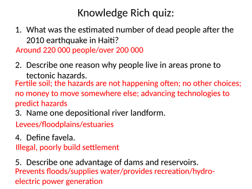
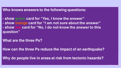
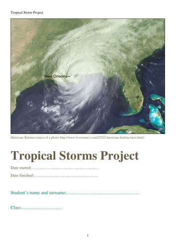
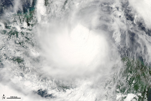
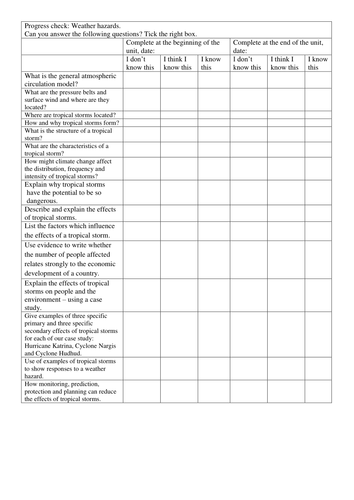
I have prepared this resource, after 2022 exam marking session for AQA, to help my students to understand exam answers’ structure even more and develop them further. I understand that not all of them will get the maximum marks but even if everyone of them can improve their answers to reach the next level then my job is done.
The resource has answer structures for 4, 6 and 9 markers for all command words I came across in the new specification past papers starting from 2018. The resource also has some connectives to help students to develop their answers.
Hope it helps you too.
The lesson is based on investigating land use around the school I teach in.
You will need tracing paper for this task.
Students start investigating the land use around the school using secondary data (Google maps), then they collect their own data using systematic sampling, then using stratify sampling. The lesson finishes with comparison of three overlays and discussion about the importance of sampling strategies in getting the most reliable data.
All resources are included apart from tracing paper, but you will have to change the satellite image of my school to a satellite image of yours.
Enjoy teaching
The lesson concentrates on collecting, presenting and analysing infiltration data collected by students. Detailed instructions in the PPT. You will need to prepare some infiltration measuring equipment if your school lacks them, i.e.: funnels = cut a plastic bottle half and use the half part as a funnel.
All paper based resources are provided in the PPT.
Enjoy teaching
Students plan and conduct their own fieldwork based on what they have learned on our previous lessons. That lesson would take at least 2 teaching hours.
All resources attached or in the PPT.
Enjoy teaching
All paper resources are provided
L1: question and hypotheses
L2: sampling and land use
L3: questionnaire
L4: transect line and litter pollution
L5: students own fieldwork
L6: infiltration fieldwork
Enjoy teaching
The worksheet is based on p.298-299 of the AQA GCSE (9-1) Geography by Hodder Education textbook and covers the sustainability aspects of UK industry with Nissan as an example.
Hope you find it useful.
The worksheets were designed to cover the following sections of the AQA specification:
changes in the UK economy
post-industrial economy
science and business parks
They are based on the two textbooks:
GCSE 9-1 Geography AQA by Oxford University Press p. 234-237
AQA GCSE (9-1) Geography by Hodder Education p.288-289
Hope you find it useful.
The worksheet focuses on population growth and decline in rural areas and on social and economic implications of those changes.
It goes with GCSE 9-1 Geography AQA by Oxford University Press textbook p.242-243
Hope you find it useful.
This lesson covers section 5.4 abc of the Edexcel A Level Geography specification.
The lesson is based on two textbooks:
Geography for Edexcel A Level Year 2 by Oxford
Edexcel A Level Book 2 Geography by Hodder Education
All resources are included within the PPT
The lesson introduces fieldwork to students. Focuses on setting the enquiry question and hypotheses.
All resources are included in the PPT.
Enjoy teaching
The lesson is based around questionnaire design based on secondary data and presenting and analyzing data after the student collects it in their own class. I always collect additional data from other classes that I teach and they have a more reliable picture overall. Students enjoy the data processing and presentation aspects. It most definitely take you more than one lesson.
All resources needed are in the PPT or attached.
Enjoy teaching
The lesson concentrates on collecting data using a transect lines and then comparing different areas of school. The lesson is based on my school but that can be quickly changed into yours.
Students present data using scatter and radar graphs.
All resources needed are included in the PPT or attached.
Enjoy teaching
How does water flow into rivers? is a second lesson in the KS3 Geography Rivers scheme of work. Key ideas: OS map reading (geographical skills), terminology definitions (knowledge), reading comprehension (understanding), assessment focus ‘describe a sequence of…’ (exam skills).
Full introduction lesson to Rivers unit for KS3 Geography national curriculum.
Key ideas: definitions of ‘river’ and ‘landscape’ (knowledge), examples of UK rivers (map skills), command word for an assessment ‘describe’ (exam skills), examples of rivers importance (knowledge).
Lesson 5 focuses on waterfall formation, using the High Force Waterfall on the River Tees as an example.
Key ideas: using a photo of a waterfall to identify some features of this landform (geographical skills), key terminology and names of waterfall features (knowledge), using resources, i.e.: photos (application of knowledge), assessment type questions ‘explain’ and ‘label’ (exam skills), knowledge recall (knowledge), making 3D model of a waterfall (creativity).
Lesson 4 focuses on long and cross profiles of the River Tees. This lesson requires ‘Progress in Geography KS3’ textbook by Hodder Education. Key ideas: drawing a long profile using data and cross profile using an OS map (geographical skills), key terminology and characteristics of upper, middle and lower course of a river (knowledge), using resources, i.e.: OS maps (application of knowledge), assessment type questions ‘describe’ and ‘compare’ (exam skills), knowledge recall (knowledge).
Lesson 3 focuses on river processes. Key ideas: photo and diagram analysis (geographical and exam skills), key terminology (knowledge), using resources (application of knowledge), resource based assessment type question (exam skills), knowledge recall (knowledge).
Lesson 7 focuses on formation of floodplains and levees. This lesson requires ‘AQA 9-1 GCSE Geography’ textbook by Hodder Education.
Key ideas:
Geographical skills: analyzing diagrams and an OS map, using an OS map extract to simplify it, calculating distance using 1:50000 scale
Exam skills: assessment type questions ‘working with an OS map’, time management, knowledge recall
Knowledge: key terms definitions, sequence of a floodplain and levees formation