Thank you for visiting! Here you will find a selection of printable, interactive worksheets for your classroom: Basic Geography worksheets with simple maps, ESL, Spanish, Bible, Reading Comprehension and more. I hope you find the resources useful! Reviews are welcome and very much appreciated. Thank you so much.
Thank you for visiting! Here you will find a selection of printable, interactive worksheets for your classroom: Basic Geography worksheets with simple maps, ESL, Spanish, Bible, Reading Comprehension and more. I hope you find the resources useful! Reviews are welcome and very much appreciated. Thank you so much.
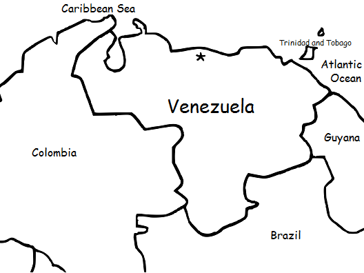
Introduce your students to Venezuela with this printable handout of two worksheets (plus answer key). Your students will read a brief overview of Venezuela (location, capital, language, flag), write 'Caracas' next to the star on the map to show the capital, color the small map of Venezuela and surrounding countries, and use the map and compass to answer (6) questions. Basic Geography worksheet with a simple map to introduce the country of Venezuela and practice cardinal and ordinal directions.
For use with Interactive Notebooks: After the handout is completed, students can cut out the map and flag of Venezuela and paste into the notebook under the topic of South America/Sub-Topic: Venezuela. Under the map, students can write a summary in their own words of what they now know about this country. Collect handouts for other countries of South America (or Spanish-speaking countries) to add to the notebook. Please browse this store for a selection of printable handouts for other countries of South America (and beyond!).
Thank you so much for using my Geography worksheets in your classroom! I hope you find them useful. Reviews are welcome and very much appreciated.
Thank you again!
Key Words: coloring page, color, cardinal, ordinal, Trinidad and Tobago, Spanish, Caribbean Sea, Atlantic Ocean
This packet of printable handouts can be used as a supplement to the printable book https://www.tes.com/teaching-resource/my-spanish-picture-dictionary-11829384 or on its own.
This packet includes WINTER vocabulary words in SPANISH: winter, coat, hat, gloves, mittens, snowman, boots, scarf, sled, skate. Español: el invierno, el patín, las botas, el abrigo, el trineo, el muñeco de nieve, la bufanda, los mitones, los guantes, el gorro
Page 1: Read and write the Winter word in Spanish. 1-5
Page 2: Read and write the Winter word in Spanish. 6-9
Page 3: Match the Winter word in Spanish with the correct picture.
Page 4: Word Search - Find the Winter words in Spanish.
Page 5: QUIZ: Write the correct Winter word in Spanish next to each picture.
Page 6: Quiz Answer Key.
Page 7: Word Search Answer Key.
Thank you so much for using my printable worksheets in your classroom!
Introduce your students to Belarus with two worksheets (plus answer key). Your students will read a brief introduction to Belarus (location, capital, flag, language), write 'Minsk' next to the star on the map to show the location of the capital, color the small map and flag, and use the map and compass to answer 6 questions on page 2. Colored pencils and a pen or pencil are needed for this activity. No other prep needed. Basic Geography worksheet with a simple map to introduce Belarus and practice cardinal/ordinal directions.
For use with Interactive Notebooks: After the worksheets are completed, students can cut out the map and flag and paste into the notebook under the topic of Europe/Sub-topic: Belarus. Under the map, students can write a summary in their own words of what they now know about this country. Collect worksheets for other countries of Europe to add to the notebook! All available in this store. Please browse this store for a selection of worksheets for other countries of Europe (and beyond!).
Thank you so much for using my Geography worksheets in your classroom! I hope you find them useful. Reviews are welcome and very much appreciated.
Introduce your students to Argentina with this printable handout of two worksheets (plus answer key). Your students will read a brief overview of Argentina (location, capital, flag, language), write 'Buenos Aires' next to the star on the map to show the capital, color the small map and flag, and use the map and compass to answer 7 questions. Colored pencils and a pen or pencil are needed for this activity. No other prep needed. Basic Geography worksheet with a simple map to introduce Argentina and practice cardinal and ordinal directions.
For use with Interactive Notebooks: After the worksheets are completed, students can cut out the map and paste into the notebook under the topic of South America/Sub-topic: Argentina. Under the map, students can write a summary in their own words of what they now know about this country. Collect worksheets for other countries of South America to add to the notebook! Please browse this store for a selection of printable worksheets for other countries of South America (and beyond)!
Thank you so much for using my Geography worksheets in your classroom!
Introduce your learners to AUSTRIA with two worksheets (plus answer key). Your students will read a brief introduction to Austria (location, capital, flag, language), write ‘Vienna’ next to the star on the map to show the location of the capital, color the small map and flag, and use the map and compass to answer 7 questions on page 2. Colored pencils and a pen or pencil are needed for this activity. No other prep needed. Basic Geography worksheet with a simple map to introduce Austria and practice cardinal and ordinal directions.
For use with Interactive Notebooks: After the worksheets are completed, students can cut out the map and flag and paste into the notebook under the topic of Europe / Sub-topic: Austria. Under the map, students can write a summary in their own words of what they now know about Austria. Collect worksheets for other countries of Europe to add to the notebook! All available in this store! Please browse this store for a selection of printable Geography worksheets for other countries of Europe (and beyond!).
Thank you for using my Geography worksheets in your classroom! I hope you find them useful. Reviews are welcome and very much appreciated!
German
Introduce your learners to Finland with two worksheets (plus answer key). Your students will read a brief introduction to Finland (location, capital, flag, language), write 'Helsinki' next to the star on the map to show the location of the capital, color the map, and use the map and compass to answer 6 questions on page 2. Colored pencils and a pen or pencil are needed for this activity. No other prep needed. Basic Geography worksheet with a simple map to introduce Finland and practice cardinal and ordinal directions.
For use with Interactive Notebooks: After completing the worksheets, students can cut out the map and flag and paste it into the notebook under the topic of Europe / Sub-Topic: Finland. Under the map and flag, students can write a summary in their own words of what they now know about Finland. Collect worksheets for other countries of Europe to add to the notebook! Please browse this store for worksheets for other countries of Europe (and beyond!)
Thank you so much for using my worksheets in your classroom!
Introduce your students to Hungary with two worksheets (plus answer key). Your students will read a brief introduction to Hungary (location, capital, flag, language), write 'Budapest' next to the star on the map to show the location of the capital, color the small map and flag, and use the map and compass to answer 9 questions on page 2. Colored pencils and a pen or pencil are needed for this activity. No other prep needed. Basic Geography worksheet with a simple map to introduce Hungary and practice cardinal and ordinal directions.
For use with Interactive Notebooks: After completing the worksheets, students can cut out the map and flag and paste it into the notebook under the topic of Europe / Sub-Topic: Hungary. Under the map and flag, students can write a summary in their own words of what they now know about this country. Collect worksheets for other countries of Europe to add to the notebook! Please browse this store for a selection of worksheets for other countries of Europe (and beyond!).
Thank you so much for using my Geography worksheets in your classroom! Reviews are welcome and very much appreciated.
Introduce your students to Czech Republic with this printable handout of two worksheets (plus answer key). Your students will read a brief overview of Czech Republic (location, capital, flag, language), write 'Prague' next to the star on the map to show the capital, color the small flag and map, and use the map and compass to answer 7 questions. Colored pencils and a pen or pencil are needed for this activity. No other prep needed.
For use with Interactive Notebooks: After completing the handout, students can cut out the map and flag and paste it into the notebook under the topic of Europe / Sub-Topic: Czech Republic. Under the map and flag, students can write a summary in their own words of what they now know about Czech Republic. Collect handouts for all countries of Europe to add to notebook.
Thank you so much for using my Geography worksheets in your classroom! Reviews are welcome and very much appreciated. Please follow my store for more Geography worksheets.
Thank you again!
cardinal, ordinal, directions, Czechoslovakia, north, south, east, west.
Introduce your students to the country of Paraguay in South America with this printable handout of two worksheets (plus answer key). Your students will read a brief introduction to Paraguay (location, capital, flag, language), write 'Asunción' next to the star on the map to show the location of the capital, color the map and flag, and use the map and compass to answer 6 questions on page 2. Colored pencils and a pen or pencil are needed for this activity. No other prep needed. Basic Geography worksheet with a simple map to introduce the country of Paraguay and practice cardinal and ordinal directions.
For use with Interactive Notebooks: After the worksheets for Paraguay are completed, students can cut out the map and flag and paste into the notebook under the topic of South America/Sub-Topic: Paraguay. Under the map, students can write a summary in their own words of what they now know about this country. Please browse this store for a selection of worksheets for other countries of South America (and beyond!)
Thank you so much for using my Geography worksheets in your classroom! Reviews are welcome and very much appreciated!
Introduce your learners to South America one country at a time with printable handouts for each country. For each country of South America, your students will read a brief overview of the country (location, capital, flag, language), write the capital next to the star on the map, color the small map and flag, and use the map and compass to answer questions and identify the locations of surrounding countries. Printable handouts for countries of South America include: Argentina, Bolivia, Brazil, Chile, Colombia, Ecuador, Guyana, Paraguay, Peru, Suriname, Uruguay, Venezuela, and French Guiana. Colored pencils and a pen or pencil are needed for this activity. Cover one country a day or one country a week. Use the printable handouts for South America (South America List of Countries and Capitals, Fill in the Blanks, Word Search) after individual countries are completed. For use with Interactive Notebooks: After your student completes the handout for a country, cut out the map and flag and paste into the notebook under the topic of South America / Sub-Topic (country). Under the map and flag, the student will write a summary in their own words about what they now know about that country.
Thank you for using my Geography worksheets in your classroom!
Introduce your students to Uruguay with this printable handout of two worksheets (plus answer key). Your students will read a brief overview of Uruguay (location, capital, language, flag), write 'Montevideo' next to the star on the map to show the capital, color the small map and flag, and use the map and compass to answer 7 questions. Basic Geography worksheet with a simple map to introduce Uruguay and practice cardinal and ordinal directions.
For use with Interactive Notebooks: After the handout is completed, students can cut out the map and flag and paste into the notebook under the topic of South America/Sub-Topic: Uruguay. Under the map, your students will write a summary in their own words of what they now know about this country. Collect handouts for other countries of South America to add to the notebook! Please browse this store for a selection of printable Geography worksheets for other countries of South America (and beyond!).
Thank you so much for using my Geography worksheets in your classroom! I hope you find them useful. Reviews are welcome and very much appreciated. Please follow this store for more printables.
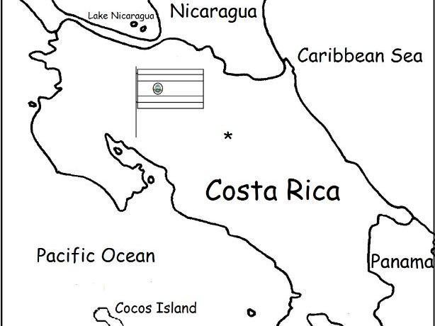
Introduce your students to Costa Rica with two worksheets (plus answer key). Your students will read a brief introduction to Costa Rica (location, capital, language, flag), write 'San José' next to the star on the map to show the location of the capital, color the small flag and map, and use the map and compass to answer 6 questions on page 2. Colored pencils and a pen or pencil are needed for this activity. No other prep needed. Basic Geography worksheet with a simple map to introduce Costa Rica and practice cardinal and ordinal directions.
For use with Interactive Notebooks: After the worksheets are completed, students can cut out the map and flag and paste into the notebook under the topic of Central America (or Spanish-Speaking Countries) /Sub-Topic: Costa Rica. Under the map and flag, students can write a summary in their own words of what they now know about this country. Collect worksheets for other countries of Central America (or Spanish-Speaking Countries) to add to the notebook! Worksheets for all countries available in this store! Please browse this store for a selection of printable Geography worksheets for other countries of Central America and beyond!
Thank you so much for using my Geography worksheets in your classroom! I hope you find them useful. Reviews are welcome and very much appreciated! Please browse this store for a selection of worksheets to introduce your learners to the countries of the world!
Teach Spanish to beginners with this printable interactive picture dictionary. This includes 56 handouts and 200 words in Spanish with pictures to color. Topics include fruit, vegetables, animals, sports, action verbs, numbers, and more (list of topics below). Every page includes a group of 7-10 words on a specific topic with pictures to color, followed by a Word Review page where your students can write the definition in their own word/s. As your students complete each page, they can use the Spanish Pronunciation Guide to practice saying each word. Teachers can do one topic (2 handouts) per day or one topic per week. Your students will save every completed coloring page and Word Review page and when all topics are completed, they will staple it into their own book to keep. A Cover Page, Table of Contents, Spanish Pronunciation Guide, and Index are included. Crayons or colored pencils and a pen or pencil are needed for this activity. No other prep needed.
List of topics:
bathroom - el baño
classroom - el salón de clases
clothing - la ropa
communication - comunicación
containers - contenedores
face - la cara
farm animals - animales de la granja
foot - el pie
fruit - la fruta
hand - la mano
kitchen - la cocina
kitchen things - cosas de la cocina
living room - la sala
nature - la naturaleza
numbers - los numeros
pets - mascotas
sports - los deportes
summer - el verano
table setting - en la mesa
tools - herramientas
traffic light - el semáforo
transportation - el transporte
vegetables - los vegetales
verbs – Action - verbos – Acciones
wild animals - animales salvajes
winter - el invierno
Illustrations used with permission from Pro Lingua Associates, publisher of ESL resources and Coloring in English - A Vocabulary Builder for Beginners, by Tracy Speelman. 'Coloring in English' includes an additional 200 words in English with pictures to color and learn. www.Prolinguaassociates.com
Thank you!
Teach VEGETABLES in SPANISH with this printable packet of 7 worksheets. This packet can be used as a supplement to the printable book (My Spanish Picture Dictionary), or on its own. No prep needed. Vegetables included: broccoli, corn, celery, onion, lettuce, tomato, cucumber, pepper, carrot.
Page 1/2: Your students will read and write the word in Spanish next to the picture of each vegetable.
Page 3: Match the vegetable with the correct word.
Page 4: Word Search: Find the name of each vegetable in Spanish.
Page 5: Fill in the blank to complete each word.
Page 6: QUIZ: Write the word in Spanish next to each vegetable.
Page 7: Answer Key.
Introduce your students to French Guiana with this printable handout of 2 worksheets (plus answer key). Your students will read a brief overview of French Guiana (location, capital, language, flag), write 'Cayenne' next to the star on the map to show the capital, color a small map and flag, and use the map and compass to answer 6 questions. Basic Geography worksheet with a simple map to introduce French Guiana and practice cardinal and ordinal directions.
For use with Interactive Notebooks: After the handout is completed, students can cut out the map and flag and paste into the notebook under the topic South America/Sub-Topic: French Guiana. Under the map, your students can write a summary in their own words of what they now know about French Guiana. Collect handouts for other countries of South America to add to the notebook. Please browse this store for a selection of printable handouts of other countries of South America (and beyond!).
Thank you so much for using my Geography worksheets in your classroom! Reviews are welcome and very much appreciated.
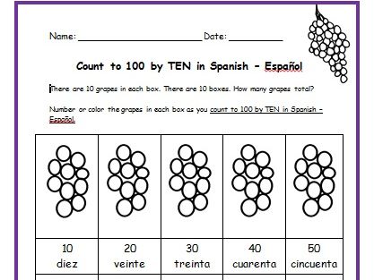
Teach your students how to count to 100 by TEN in Spanish with this packet of printable handouts. Colored pencils and a pen or pencil are needed for this activity.
Page 1: There are 10 grapes in 10 boxes. Each box is numbered by tens in Spanish. Directions for student: Number and/or color the grapes in each box.
Page 2: Write the word in Spanish (10, 20, 30, 40, 50)
Page 3: Write the word in Spanish - Page 2 (60, 70, 80, 90, 100)
Page 4: Match the word in Spanish with the correct number. Then check your own
answers using your coloring page.
Page 5: Word Search: Find each word in Spanish.
Page 6: Fill in the blank.
Page 7: Quiz: Write the correct word in Spanish next to each number.
Page 8: Answer Key.
Teach Spanish and English to beginners with this printable bilingual, interactive picture dictionary. This includes 54 printable handouts and over 200 everyday, basic vocabulary words in Spanish and English with pictures to color and learn. Words are grouped into 25 topics with 6-9 pictures to color on each page, followed by a Word Review page. Teachers can cover one topic at a time. Students will save all completed handouts and staple it into a book to keep. A Cover Page, Table of Contents, and Index are included. Colored pencils or crayons are needed for this activity. No other prep needed.
Topics include: bathroom, classroom, clothing, communication, containers, face, farm animals, foot, fruit, hand, kitchen, kitchen items, living room, nature, numbers, pets, sports, summer, table setting, tools, traffic light, transportation, vegetables, verbs, wild animals, winter. Español: el baño, el salón de clases, la ropa, comunicación, contenedores, la cara
animales de la granja, el pie, la fruta, la mano, la cocina, cosas de la cocina, la sala, la naturaleza, los numeros, mascotas, los deportes, el verano, en la mesa, herramientas, el semáforo, el transporte, las verduras, verbos – acciones, animales salvajes, el invierno
Illustrations used with permission from Pro Lingua Associates, publisher of Coloring in English - A Vocabulary Builder for Beginners, by Tracy Speelman. http://www.prolinguaassociates.com/
Translations by Javier Morales, Bilingual Special Education Advocate and Founder of Parents Ask - Understanding Disabilities One Question at a Time. https://parentsask.net/
This printable handout includes a map of Ecuador and surrounding countries. Directions: Write ‘Quito’ next to the star on the map to show the capital of Ecuador. Fill in the blanks on the map for each country (Ecuador, Peru, Colombia, Pacific Ocean). Color the map. Then using your map and compass, answer 4 questions on page 2.
Crayons or colored pencils are needed for this activity. No other prep needed.
This printable handout of 2 pages (plus answer key) includes a map and flag of Colombia. Your students will fill in the blanks for each Colombia and surrounding countries (Venezuela, Brazil, Peru, Ecuador, and Panama) and the Atlantic and Pacific Ocean, write Bogotá next to the star on the map to show the capital of Colombia, color the flag and map, and then use the map and compass to answer 7 questions.
Mexico is located south of the United States and north of Central America. Introduce your learners to Mexico and surrounding with this printable map activity! Two worksheets (plus answer key).
Page 1:
FILL IN THE BLANKS on the map for each of the following: Alabama, Arizona, Arkansas, Atlantic Ocean, Belize, California, Caribbean Sea, Costa Rica, Cuba, El Salvador, Florida, Georgia, Guatemala, Gulf of Mexico, Honduras, Louisiana, Mexico, Mississippi, New Mexico, Nicaragua, Oklahoma, Pacific Ocean, Panama, South Carolina, Texas.
COLOR CODE: Choose a color for the United States, Mexico, Central America, and Bodies of Water. Then color the map.
Page 2: Use your completed map and compass to answer 7 questions.
Page 3: Answer Key.
Colored pencils and a pen or pencil are needed for this activity. No other prep needed.
Thank you so much for using my printables with your learners! I hope you find them useful. Reviews are welcome and very much appreciated. Please browse this store for more worksheets to introduce your learners to the countries of the world!