Thank you for visiting! Here you will find a selection of printable, interactive worksheets for your classroom: Basic Geography worksheets with simple maps, ESL, Spanish, Bible, Reading Comprehension and more. I hope you find the resources useful! Reviews are welcome and very much appreciated. Thank you so much.
Thank you for visiting! Here you will find a selection of printable, interactive worksheets for your classroom: Basic Geography worksheets with simple maps, ESL, Spanish, Bible, Reading Comprehension and more. I hope you find the resources useful! Reviews are welcome and very much appreciated. Thank you so much.
Introduce your students to Spain with two worksheets (plus answer key). Your students will read a brief introduction to Spain (location, capital, flag, language), write ‘Madrid’ next to the star on the map to show the location of the capital, color the flag and map, and use the map and compass to answer 7 questions on page 2. Colored pencils and a pen or pencil are needed for this activity. No other prep needed. Basic Geography worksheet includes a simple map to introduce Spain and practice cardinal/ordinal directions.
For use with Interactive Notebooks: After completing the worksheets, students can cut out the map and flag and paste into the notebook under the topic of Europe (or Spanish-Speaking Countries), Sub-Topic: Spain. Under the map and flag, students can write a summary in their own words of what they now know about this country. Collect worksheets for other countries of Europe to add to the notebook! Please browse this store for a selection of worksheets for other countries of Europe (and beyond!).
Thank you so much for using my worksheets in your classroom! I hope you find them useful. Reviews are welcome and very much appreciated.
Teach Spanish and English to beginners with this printable dual-language, interactive picture dictionary. This includes 54 printable handouts with over 200 everyday, basic vocabulary words in Spanish and English with pictures to color and learn. Words are grouped into 25 topics with 6-9 pictures to color on each page, followed by a Word Review page. Teachers can cover one topic at a time. Students will save all completed handouts and staple it into a book to keep. A Cover Page, Table of Contents, and Index are included. Colored pencils or crayons are needed for this activity. No other prep needed.
Topics include:
English: bathroom, classroom, clothing, communication, containers, face, farm animals, foot, fruit, hand, kitchen, kitchen items, living room, nature, numbers, pets, sports, summer, table setting, tools, traffic light, transportation, vegetables, verbs, wild animals, winter.
Español: el baño, el salón de clases, la ropa, comunicación, contenedores, la cara, animales de la granja, el pie, la fruta, la mano, la cocina, cosas de la cocina, la sala, la naturaleza, los numeros, mascotas, los deportes, el verano, en la mesa, herramientas, el semáforo, el transporte, las verduras, verbos – acciones, animales salvajes, el invierno
Reinforce new vocabulary in Spanish and English with supplemental packets! Please click on the following links for supplemental worksheets to use with this book:
VEGETABLES / LAS VERDURAS : https://www.tes.com/teaching-resource/spanish-and-english-vegetables-12005291
NUMBERS 1-10: https://www.tes.com/teaching-resource/bilingual-numbers-1-10-spanish-and-english-12014759
The supplemental packets include 7 printable worksheets to use after completing the topic with the bilingual picture dictionary. With this supplemental packet, your students will read and write each new word, match the word in English and Spanish with the correct picture, find all new words in the Word Search, Fill-in-the-Blanks, and take the quiz. Answer key included in each packet.**
Thank you so much for using my worksheets in your classroom!
Illustrations used with permission from Pro Lingua Associates, publisher of 'Coloring in English - A Vocabulary Builder for Beginners, by Tracy Speelman. Coloring in English includes 400 everyday, basic vocabulary words in English with pictures to color and learn: http://www.prolinguaassociates.com/
Translations by Javier Morales, Bilingual Special Education Advocate and Founder of Parents Ask - Understanding Disabilities One Question at a Time. https://parentsask.net/
Introduce your students to UKRAINE with this printable handout of two worksheets (plus answer key). Your students will read a brief introduction to Ukraine (location, capital, flag, language), write 'Kiev' next to the star on the map to show the location of the capital, color the small map and flag, and use the map and compass to answer 7 questions on page 2. Colored pencils and a pen or pencil are needed for this activity. No other prep needed. Basic Geography worksheet with a simple map to introduce the Ukraine and practice cardinal and ordinal directions.
For use with Interactive Notebooks: After the worksheets are completed, students can cut out the map and flag and paste into the notebook under the topic of Europe/Sub-Topic: Ukraine. Under the map, students can write a summary in their own words of what they now know about this country. Collect worksheets for other countries of Europe to add to the notebook! All available in this store. Please browse this store for a selection of printable handouts for other countries of Europe (and beyond!).
Thank you so much for using my Geography worksheets in your classroom! I hope you find them useful. Reviews are welcome and very much appreciated!
Introduce your students to Guatemala with two printable worksheets (plus answer key). Your students will read a brief introduction to Guatemala (location, capital, flag, language), write ‘Guatemala City’ next to the star on the map to show the location of the capital, color the small flag and map, and use the map and compass to answer 7 questions on page 2. Colored pencils and a pen or pencil are needed for this activity. No other prep needed. Basic Geography worksheet with a simple map to introduce Guatemala and practice cardinal and ordinal directions.
For use with Interactive Notebooks: After the worksheets are completed, students can cut out the map and flag and paste into the notebook under the topic of Central America (or Spanish-Speaking Countries)/ Sub-Topic: Guatemala. Under the map and flag, students can write a summary in their own words about what they now know about this country. Collect worksheets for other countries to add to the notebook! Please browse this store for worksheets for other countries of Central America and beyond!!
Thank you so much for using my Geography worksheets in your classroom! I hope you find them useful. Reviews are welcome and very much appreciated. Please browse this store for worksheets to introduce your students to the countries of the world!
Libertad 15 de Septiembre de 1821, cardinal, ordinal directions, Spanish, Mexico, Belize, Honduras, El Salvador, Caribbean Sea, Pacific Ocean.
This printable handout includes a map of the United States to color and learn. Crayons or colored pencils are needed for this activity. No other prep needed.
Introduce your students to Nicaragua with two printable worksheets (plus answer key). Your students will read a brief introduction to Nicaragua (location, capital, flag, language), write ‘Managua’ next to the star on the map to show the location of the capital, color the small flag and map, and use the map and compass to answer 7 questions on page 2. Colored pencils and a pen or pencil are needed for this activity. No other prep needed. Basic Geography worksheet with a simple map to introduce Nicaragua and practice cardinal and ordinal directions.
For use with Interactive Notebooks: After the worksheets are completed, students can cut out the map and flag and paste into the notebook under the topic of Central America (or Spanish-speaking countries) /Sub-Topic: Nicaragua. Under the map and flag, students can write a summary in their own words of what they now know about this country. Collect worksheets for other countries of Central America to add to the notebook! Please browse this store for a selection of printable handouts for other countries of Central America (and beyond!)
Thank you so much for using my Geography worksheets in your classroom! I hope you find them useful. Reviews are welcome and very much appreciated! Please browse this store for worksheets to introduce your students to the countries of the world!
This printable handout includes a Spanish Pronunciation Quick Guide for vowels and consonants with 5 words and pictures to practice. Directions: Use the Spanish Pronunciation Guide on the left to pronounce the words on the right.
Words/Pictures included in Spanish:
chicken - la gallina
frog - la rana
carrot - la zanahoria
hammer - el martillo
bathtub - la bañera
This is a great activity to prepare your students to increase their Spanish vocabulary. From here, your students can begin creating their own Spanish Picture Dictionary and continue to expand vocabulary with use of this pronunciation guide. For more information, please visit ‘My Spanish Picture Dictionary’ https://www.tes.com/teaching-resource/my-spanish-picture-dictionary-11829384 in my shop.
Thank you so much!!
Printable Handout (1 page plus answer key) ‘A Summer Day at the Beach.’ Students will fill in the blanks using the word bank of past-tense verbs: parked, swam, collected, drove, decided, watched, walked, sat, read, ate, packed, carried.
Cloze activity for ESL, EFL, ELL, ESOL. Vocabulary building, Reading Comprehension, Grammar.
Introduce your students to NEW ZEALAND with this printable handout of two worksheets (plus answer key). Your students will read a brief overview of New Zealand (location, capital, flag, language), write ‘Wellington’ next to the star on the map to show the capital, color the small map, and use the map and compass to answer 7 questions. Colored pencils and a pen or pencil are needed for this activity. Basic Geography worksheet with a simple map to introduce New Zealand and practice cardinal and ordinal directions.
For use with Interactive Notebooks: After the handout is completed, students can cut out the map and flag of New Zealand and paste into the notebook. Under the map and flag, students can write a summary in their own words of what they now know about New Zealand. Collect handouts for other countries to add to the notebook. Please check out my store for a selection of worksheets for other countries!
Thank you so much for using my Geography worksheets in your classroom. I hope you find them useful. Reviews are welcome and very much appreciated! Happy Teaching!
Included: Auckland, North Island, South Island, Cook Strait, Stewart Island, Pacific Ocean, Tasman Sea.
Introduce your students to Uganda with two worksheets (plus answer key). Your students will read a brief introduction to Uganda (location, capital, flag, language), write ‘Kampala’ next to the star on the map to show the location of the capital, color the small map, and use the map and compass to answer 8 questions on page 2. Colored pencils and a pen or pencil are needed for this activity. No other prep needed. Basic Geography worksheet with a simple map to introduce the country of Uganda and practice cardinal/ordinal directions.
For use with Interactive Notebooks: After the worksheets are completed, students can cut out the map and flag and paste into the notebook under the topic of Africa / Sub-topic: Uganda. Under the map and flag, your students can write a summary in their own words of what they now know about this country. Collect worksheets for other countries of Africa to add to the notebook! Please browse this store for a selection of worksheets for other countries of Africa (and beyond!).
Thank you so much for using my Geography worksheets in your classroom! I hope you find them useful. Reviews are welcome and very much appreciated!
Introduce your learners to MADAGASCAR in Africa with two worksheets (plus answer key). Your students will read a brief introduction to Madagascar (location, capital, flag, language), write ‘Antananarivo’ next to the star on the map to show the location of the capital, color the small map, and use the map and compass to answer 6 multiple-choice questions on page 2. Colored pencils and a pen or pencil are needed for this activity. No other prep needed. Basic Geography worksheet with a simple map to introduce the country of Madagascar and practice cardinal/ordinal directions.
For use with Interactive Notebooks: After the worksheets are completed, students can cut out the map and flag and paste into the notebook under the topic of Africa / Sub-topic: Madagascar. Under the map and flag, your students can write a summary in their own words of what they now know about this country. Collect worksheets for other countries of Africa to add to the notebook! All available in this store!
Thank you so much for using my Geography worksheets in your classroom! I hope you find them useful. Reviews are welcome and very much appreciated! Please browse this store for worksheets to introduce your learners to all countries of Africa and the world!
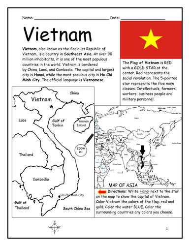
Introduce your students to VIETNAM with this printable handout of two worksheets (plus answer key). Your students will read a brief introduction to Vietnam (location, capital, flag, language), write 'Hanoi’ next to the star on the map to show the capital, color the small map of Vietnam and surrounding, and use the map and compass to answer 7 questions on page 2. Colored pencils and a pen or pencil are needed for this activity. No other prep needed. Basic Geography worksheet with a simple map to introduce Vietnam and practice cardinal and ordinal directions.
For use with Interactive Notebooks: After the worksheets are completed, students can cut out the map and flag and paste into the notebook under the topic of Asia/Sub-Topic: Vietnam. Under the map and flag, your students can write a summary in their own words of what they now know about Vietnam. Collect handouts for other countries of Asia to add to the notebook! All available in this store. Please browse this store for a selection of printable Geography worksheets for countries of Asia (and beyond!).
Thank you for using my Geography worksheets in your classroom! I hope you find them useful. Reviews are welcome and very much appreciated!
Introduce your learners to South America one country at a time with printable handouts for each country. For each country of South America, your students will read a brief overview of the country (location, capital, flag, language), write the capital next to the star on the map, color the small map and flag, and use the map and compass to answer questions and identify the locations of surrounding countries. Printable handouts for countries of South America include: Argentina, Bolivia, Brazil, Chile, Colombia, Ecuador, Guyana, Paraguay, Peru, Suriname, Uruguay, Venezuela, and French Guiana. Colored pencils and a pen or pencil are needed for this activity. Cover one country a day or one country a week. Use the printable handouts for South America (South America List of Countries and Capitals, Fill in the Blanks, Word Search) after individual countries are completed. For use with Interactive Notebooks: After your student completes the handout for a country, cut out the map and flag and paste into the notebook under the topic of South America / Sub-Topic (country). Under the map and flag, the student will write a summary in their own words about what they now know about that country.
Thank you for using my Geography worksheets in your classroom!
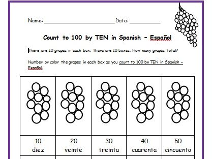
Teach your students how to count to 100 by TEN in Spanish with this packet of printable handouts. Colored pencils and a pen or pencil are needed for this activity.
Page 1: There are 10 grapes in 10 boxes. Each box is numbered by tens in Spanish. Directions for student: Number and/or color the grapes in each box.
Page 2: Write the word in Spanish (10, 20, 30, 40, 50)
Page 3: Write the word in Spanish - Page 2 (60, 70, 80, 90, 100)
Page 4: Match the word in Spanish with the correct number. Then check your own
answers using your coloring page.
Page 5: Word Search: Find each word in Spanish.
Page 6: Fill in the blank.
Page 7: Quiz: Write the correct word in Spanish next to each number.
Page 8: Answer Key.
Introduce your learners to Panama with two printable worksheets (plus answer key). Your students will read a brief introduction to Panama (location, capital, flag, language), write ‘Panama City’ next to the star on the map to show the location of the capital, color the small flag and map, and use the map and compass to answer 10 questions on page 2. Colored pencils and a pen or pencil are needed for this activity. No other prep needed. Basic Geography worksheet with a simple map to introduce Panama and practice cardinal and ordinal directions.
For use with Interactive Notebooks: After the worksheets are completed, students can cut out the map and flag and paste into the notebook under the topic of (example): Central America or Spanish-Speaking Countries / Sub-Topic: Panama. Under the map and flag, students can write a summary in their own words about what they now know about this country. Collect worksheets for other countries of Central America (or Spanish-Speaking Countries) to add to the notebook! All available in this store! Please browse this store for worksheets for countries of Central America and beyond!
Thank you so much for using my Geography worksheets in your classroom! I hope you find them useful. Reviews are welcome and very much appreciated! Please browse this store for worksheets to introduce your learners to the countries of the world!
Key words: Panama canal, Spanish, cardinal, ordinal directions.
Introduce your students to Mexico with two printable worksheets (plus answer key). Your students will read a brief introduction to Mexico (location, capital, flag, language), write ‘Mexico City’ next to the star on the map to show the location of the capital, write ‘U.S.’ in each state of the United States, write ‘C.A.’ in each country of Central America, color the map and flag of Mexico, and use the map and compass to answer 7 questions on page 2. Colored pencils and a pen or pencil are needed for this activity. No other prep needed. Basic Geography worksheet with a simple map to introduce Mexico and practice cardinal and ordinal directions.
For use with Interactive Notebooks: After the worksheets are completed, students can cut out the map and flag and paste into the notebook under the topic of (example): Spanish-Speaking Countries / Sub-Topic: Mexico. Under the map, your students can write a summary in their own words of what they now know about this country. Collect worksheets for other Spanish-speaking countries to add to the notebook! All available in this store!
Thank you so much for using my worksheets in your classroom! I hope you find them useful. Reviews are welcome and very much appreciated! Please browse this store for a selection of worksheets to introduce your learners to the countries of the world!
Find the books of the Old Testament in the Word Search Puzzle. They can be found forward or backward. After all the books are found, write the remaining letters on the lines below for the bible verse.
Bible verse: When I am afraid, I will put my trust in you. Psalm 56:3.
Books of the Old Testament:
Genesis, Exodus, Leviticus, Numbers, Deuteronomy, Joshua, Judges, Ruth, 1 Samuel, 2 Samuel, 1 Kings, 2 Kings, 1 Chronicles, 2 Chronicles, Ezra, Nehemiah, Esther, Job, Psalms, Proverbs, Ecclesiastes, Song of Solomon, Isaiah, Jeremiah, Lamentations, Ezekiel, Daniel, Hosea, Joel, Amos, Obadiah, Jonah, Micah, Nahum, Habakkuk, Zephaniah, Haggai, Zechariah, Malachi
Introduce your learners to Ireland with this printable handout of two worksheets (plus answer key). Your students will read a brief overview of Ireland (location, capital, flag, language), write ‘Dublin’ next to the star on the map to show the location of the capital, color the small map and flag, and use the map and compass to answer 6 multiple-choice questions on page 2. Colored pencils or and a pen or pencil are needed for this activity. No other prep needed. Basic Geography worksheet with a simple map to introduce the country of Ireland.
For use with Interactive Notebooks: After completing the worksheets, students can cut out the map and flag and paste it into the notebook under the topic of Europe / Sub-Topic: Ireland. Under the map, students will write a summary in their own words of what they now know about this country. Collect worksheets for other countries of Europe to add to the notebook! Please browse this store for a selection of worksheets for other countries of Europe (and beyond!).
Thank you so much for using my Geography worksheets in your classroom! I hope you find them useful. Reviews are welcome and very much appreciated.
Teach your students how to count to 100 by TEN with this printable worksheet. There are 10 grapes in 10 boxes. Each box is numbered by ten. Directions for student: Number and/or Color the grapes in each box until you get to 100.
Introduce your learners to Cuba with this printable handout of 2 worksheets (plus answer key). Your students will read a brief introduction to Cuba (location, capital, flag), write ‘Havana’ next to the star on the map to show the location of the capital, color color the flag and map of Cuba, then use the map and compass to answer 5 multiple-choice questions on page 2. Colored pencils and a pen or pencil are needed for this activity. No other prep needed. Basic Geography worksheet with a simple map to introduce Cuba and practice cardinal and ordinal directions.
For use with Interactive Notebooks: After the worksheets are completed, students can cut out the map and flag and paste into the notebook under the topic of Caribbean / Sub-topic: CUBA. Under the map, your students can write a summary in their own words of what they now know about Cuba. Collect worksheets for other countries to add to the notebook! Please browse this store for a selection of worksheets for other countries of the Caribbean (and beyond!).
Thank you so much for using my Geography worksheets in your classroom! I hope you find them useful. Reviews are welcome and very much appreciated!
Cuba and surrounding: Jamaica, Haiti, Dominican Republic, Mexico, Belize, Guatemala, Honduras, United States, Florida, the Bahamas, Caribbean Sea, Atlantic Ocean, Gulf of Mexico. North America, Central America. Cardinal, ordinal directions. Isla de la Juventud.
Note: This handout is in American English. For British English, please visit this link: https://www.tes.com/teaching-resource/cuba-printable-handout-british-english-11997673