Thank you for visiting! Here you will find a selection of printable, interactive worksheets for your classroom: Basic Geography worksheets with simple maps, ESL, Spanish, Bible, Reading Comprehension and more. I hope you find the resources useful! Reviews are welcome and very much appreciated. Thank you so much.
Thank you for visiting! Here you will find a selection of printable, interactive worksheets for your classroom: Basic Geography worksheets with simple maps, ESL, Spanish, Bible, Reading Comprehension and more. I hope you find the resources useful! Reviews are welcome and very much appreciated. Thank you so much.
Color the map of Europe. Printable handout of 1 page includes a map of Europe to color and learn.
Countries of Europe included: Albania, Andorra, Armenia, Austria, Azerbaijan, Belarus, Belgium, Bosnia and Herzegovina, Bulgaria, Croatia, Cyprus, Czech Republic, Denmark, Estonia, Finland, France, Georgia, Germany, Greece, Hungary, Iceland, Ireland, Italy, Kazakhstan, Kosovo, Latvia, Lithuania, Luxembourg, Macedonia, Malta, Moldova, Monaco, Montenegro, Netherlands, Norway, Poland, Portugal, Romania, Russia, San Marino, Serbia, Slovakia, Slovenia, Spain, Sweden, Switzerland, Turkey, Ukraine, United Kingdom, Vatican City.
Thank you for using my Geography worksheets in your classroom! I hope you find them useful. Reviews are welcome and very much appreciated. Please browse this store for a selection of worksheets to introduce your students to the countries of the world!
Using the map of the continent of Oceania, find the 14 island countries in the Word Search Puzzle. They can be found forward or backward. One printable worksheet (plus answer key). Countries included: Australia, Papua New Guinea, New Zealand, Fiji, Solomon Islands, Vanuatu, Samoa, Kiribati, Micronesia, Tonga, Marshall Islands, Palau, Tuvalu, Nauru.
Thank you so much for using my Geography worksheets! I hope you find them useful. Reviews are welcome and very much appreciated. Please browse this store for more Geography worksheets and Word Search Puzzles.
Printable handout of the map of the United States. Write the name of each state on the map (the first letter of each state is listed on the map as clues). Answer key included.
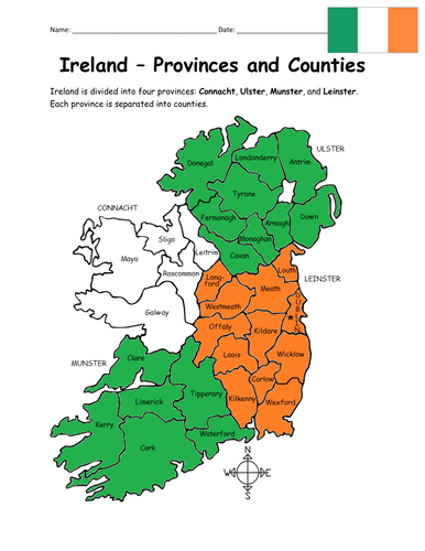
Introduce your learners to the 4 provinces and 32 counties of Ireland! Your students will use the map of Ireland to answer 10 multiple-choice questions on page 2. Answer key included. Basic Geography worksheet with a simple map to introduce the provinces and counties of Ireland. 2 worksheets (plus answer key).
Provinces and Counties included:
Connacht: Galway, Leitrim, Mayo, Roscommon, Sligo
Ulster: Antrim, Armagh, Cavan, Donegal, Down, Fermanagh, Londonderry, Monaghan, Tyrone
Munster: Cork, Kerry, Limerick, Tipperary, Waterford, Clare
Leinster: Carlow, Dublin, Kildare, Kilkenny, Laois, Longford, Louth, Meath, Offaly, Westmeath, Wexford, Wicklow
Thank you so much for using my Geography worksheets! I hope you find them useful. Reviews are welcome and very much appreciated. Please browse this store for a selection of worksheets to introduce your learners to the countries of the world!
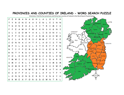
Using the map of Ireland, find the four provinces and thirty-two counties of Ireland in the Word Search Puzzle! They can be found forward or backward.
Provinces and Counties included:
Connacht: Galway, Leitrim, Mayo, Roscommon, Sligo
Ulster: Antrim, Armagh, Cavan, Donegal, Down, Fermanagh, Londonderry, Monaghan, Tyrone
Munster: Cork, Kerry, Limerick, Tipperary, Waterford, Clare
Leinster: Carlow, Dublin, Kildare, Kilkenny, Laois, Longford, Louth, Meath, Offaly, Westmeath, Wexford, Wicklow
One printable word search puzzle (plus answer key).
You may also be interested in:
IRELAND - INTRODUCTORY GEOGRAPHY WORKSHEET
IRELAND - PROVINCES AND COUNTIES INTRODUCTORY WORKSHEET
Thank you so much for using my Geography worksheets to introduce your learners to the countries of the world! I hope you find them useful. Reviews are welcome and very much appreciated.
Introduce your students to Poland with this printable handout of 2 worksheets (plus answer key). Your students will read a brief introduction to Poland (location, capital, flag, language), write 'Warsaw' next to the star on the map to show the location of the capital, color the small map and flag, and use the map and compass to answer 7 questions on page 2. Colored pencils and a pen or pencil are needed for this activity. No other prep needed. Basic Geography worksheet with a simple map to introduce Poland and practice cardinal and ordinal directions.
For use with Interactive Notebooks: After the worksheets for Poland are completed, students can cut out the map and flag and paste into the notebook under the topic of Europe/Sub-Topic: Poland. Under the map, your students can write a summary in their own words of what they now know about Poland. Collect worksheets for other countries of Europe to add to the notebook! Please browse this store for worksheets for other countries of Europe - and beyond!
Thank you so much for using my Geography worksheets in your classroom! I hope you find them useful and fun. Reviews are welcome and very much appreciated!
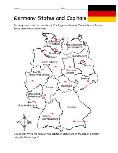
Introduce your students to the 16 states and capital cities of Germany with three worksheets (plus answer key). Using the list of states and capitals on page 2, your students will write the capital city of each state on the map of Germany (page 1). Then answer 8 true/false questions on page 3.
States - Capitals included:
Baden-Württemberg - Stuttgart
Bavaria - Munich
Berlin - Berlin
Brandenburg - Potsdam
Bremen - Bremen
Hamburg - Hamburg
Hesse - Wiesbaden
Lower Saxony - Hanover
Mecklenburg-Vorpommern - Shwerin
North Rhine-Westphalia - Düsseldorf
Rhineland-Palatinate - Mainz
Saarland - Saarbrücken
Saxony - Dresden
Saxony-Anhalt - Magdeburg
Schleswig-Holstein - Kiel
Thuringia - Erfurt
Thank you so much for using my worksheets in your classroom! I hope you find them useful. Reviews are welcome and very much appreciated. Please browse this store for more Geography worksheets!
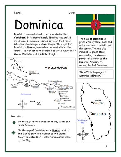
Introduce your learners to the island country of Dominica with two printable worksheets (plus answer key). Simple map activity and reading comprehension questions. Your students will read a brief introduction to Dominica (location, capital, flag, language), locate and circle Dominica on the map of the Caribbean (map 1), write ‘Roseau’ next to the star on the map of Dominica (map 2) to show the location of the capital, color the map, and use the reading passage, maps and compass to answer 10 true/false questions on page 2. Colored pencils and a pen or pencil are needed for this activity. No other prep needed. Basic Geography worksheet with a simple map to introduce Dominica and practice cardinal and ordinal directions. Print and Go!
For use with Interactive Notebooks: After the worksheets are completed, students can cut out the map and flag and paste into the notebook under the topic of (example) The Caribbean / Sub-topic: Dominica. Under the map, your students can write a summary in their own words of what they now know about Dominica. Collect worksheets of other countries of the Caribbean (or North America) to add to the notebook! All available in this store.
Thank you so much for using my Geography worksheets in your classroom! I hope you find them useful. Reviews are welcome and very much appreciated! Please browse this store for more worksheets to introduce your learners to the countries of the world!
Introduce your students to the country of Slovenia in Europe with two worksheets (plus answer key). Your students will read a brief introduction to Slovenia (location, capital, flag, language), write Ljubljana next to the star on the map to show the location of the capital, color the small map, and use the map and compass to answer 9 questions on page 2. Colored pencils and a pen or pencil are needed for this activity. No other prep needed. Basic Geography worksheet with a simple map to introduce Slovenia and practice cardinal and ordinal directions.
For use with Interactive Notebooks: After completing the worksheets, students can cut out the map and flag and paste into the notebook under the topic of Europe/Sub-Topic: Slovenia. Under the map and flag, students can write a summary in their own words of what they now know about this country. Collect worksheets for other countries of Europe to add to the notebook! Please browse this store for a list of worksheets for other countries of Europe (and beyond!).
Thank you so much for using my Geography worksheets in your classroom! I hope you find them useful. Reviews are welcome and very much appreciated!
Introduce your students to CHAD with two worksheets (plus answer key). Your students will read a brief introduction to Chad (location, capital, flag, language), write ‘N’Djamena’ next to the star on the map to show the location of the capital, color the small map, and use the map and compass to answer 9 questions on page 2. Colored pencils and a pen or pencil are needed for this activity. No other prep needed. Basic Geography worksheet with a simple map to introduce the country of Chad and practice cardinal/ordinal directions.
For use with Interactive Notebooks: After the worksheets are completed, students can cut out the map and flag and paste into the notebook under the topic of Africa/Sub-topic: Chad. Under the map and flag, your students can write a summary in their own words of what they now know about this country. Collect worksheets for other countries of Africa to add to the notebook! Please browse this store for a selection of worksheets for all other countries of Africa (and beyond!).
Thank you so much for using my Geography worksheets in your classroom! I hope you find them useful. Reviews are welcome and very much appreciated.
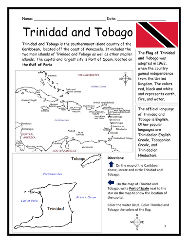
Introduce your learners to Trinidad and Tobago with two printable handouts (plus answer key). Your students will read a brief introduction to Trinidad and Tobago (location, capital, flag, language), write ‘Port of Spain’ next to the star on the map to show the location of the capital, locate and circle Trinidad and Tobago on the map of the Caribbean, color the map, and use the reading passage, maps and compass to answer 9 true/false questions on page 2. Colored pencils and a pen or pencil are needed for this activity. No other prep needed. Basic Geography worksheet with a simple map to introduce Trinidad and Tobago and practice cardinal and ordinal directions. Print and Go!
For use with Interactive Notebooks: After the worksheets are completed, students can cut out the map and flag and paste into the notebook under the topic of (example) The Caribbean / Sub-topic: Trinidad and Tobago. Under the map, your students can write a summary in their own words of what they now know about Trinidad and Tobago. Collect worksheets of other countries of the Caribbean to add to the notebook! All available in this store!
Thank you so much for using my Geography worksheets in your classroom! I hope you find them useful. Reviews are welcome and very much appreciated!
Included: Gulf of Paria, South America, United Kingdom
Introduce your students to Belgium with this printable handout of two worksheets (plus answer key). Your students will read a brief introduction to Belgium (location, capital, flag, language), write ‘Brussels’ next to the star on the map to show the capital, color the small flag and map, and use the map and compass to answer 7 questions on page 2. Colored pencils and a pen or pencil are needed for this activity. No other pep needed. Basic Geography worksheet with a simple map to introduce Belgium and practice cardinal and ordinal directions.
For use with Interactive Notebooks: After the worksheets are completed, students can cut out the map and flag and paste into the notebook under the topic of Europe/Sub-Topic: Belgium. Under the map and flag, students can write a summary in their own words of what they now know about this country. Collect worksheets for other countries of Europe to add to the notebook! All available in this store! Please browse this store for a selection of worksheets for other countries of Europe (and beyond!).
Thank you so much for using my Geography worksheets in your classroom! I hope you find them useful. Reviews are welcome and very much appreciated!
Introduce your learners to United Arab Emirates in the Middle East and Asia with this printable handout of two worksheets (plus answer key). Your students will read a brief introduction to UAE (location, capital, language, flag), write ‘Abu Dhabi’ next to the star on the map to show the location of the capital, color the small map, and use the map and compass to answer 9 questions on page 2. Colored pencils and a pen or pencil are needed for this activity. No other prep needed. Basic Geography worksheet with a simple map to introduce UAE and practice cardinal/ordinal directions.
For use with Interactive Notebooks: After your students complete the worksheets, they can cut out the map and flag of UAE and paste into the notebook under the topic of Asia or Middle East / Sub-topic: United Arab Emirates. Under the map, students can write a summary in their own words of what they now know about this country. Collect worksheets for other countries of Asia or the Middle East to add to the notebook! All available in this store. Please browse this store for a selection of printable worksheets for other countries of Asia, the Middle East, and beyond!
Thank you so much for using my Geography worksheets in your classroom! I hope you find them useful. Reviews are welcome and very much appreciated.
Included: Persian Gulf, Gulf of Oman, Arabian Peninsula, maritime borders, Arabic, Pan-Arab colors, 7 emirates
Introduce your students to Spain with two worksheets (plus answer key). Your students will read a brief introduction to Spain (location, capital, flag, language), write ‘Madrid’ next to the star on the map to show the location of the capital, color the flag and map, and use the map and compass to answer 7 questions on page 2. Colored pencils and a pen or pencil are needed for this activity. No other prep needed. Basic Geography worksheet includes a simple map to introduce Spain and practice cardinal/ordinal directions.
For use with Interactive Notebooks: After completing the worksheets, students can cut out the map and flag and paste into the notebook under the topic of Europe (or Spanish-Speaking Countries), Sub-Topic: Spain. Under the map and flag, students can write a summary in their own words of what they now know about this country. Collect worksheets for other countries of Europe to add to the notebook! Please browse this store for a selection of worksheets for other countries of Europe (and beyond!).
Thank you so much for using my worksheets in your classroom! I hope you find them useful. Reviews are welcome and very much appreciated.
Find the 21 Spanish-Speaking Countries in the Word Search Puzzle! One printable Word Search Puzzle (plus answer key).
Countries to find in the Word Search Puzzle: Argentina, Bolivia, Chile, Colombia, Costa Rica, Cuba, Dominican Republic, Ecuador, El Salvador, Equatorial Guinea, Guatemala, Honduras, Mexico, Nicaragua, Panama, Paraguay, Peru, Puerto Rico, Spain Uruguay, Venezuela.
Flags for each country included!
Please browse this store for other worksheets to introduce your learners to the Spanish-Speaking Countries! SPANISH-SPEAKING COUNTRIES FILL IN THE BLANKS, SPANISH-SPEAKING COUNTRIES SCRAMBLE, and more! Worksheets also available to introduce your learners to each Spanish-Speaking country!
Thank you so much for using my worksheets in your classroom! I hope you find them useful and fun. Reviews are welcome and very much appreciated. Please FOLLOW THIS STORE!!
Introduce your students to the country of SOUTH AFRICA with two worksheets (plus answer key). Your students will read a brief introduction to South Africa (location, capitals, flag, language), write ‘Pretoria’ next to the ‘A’ on the map to show the administrative capital; write ‘Bloemfontein’ next to the ‘J’ to show the judicial capital; write ‘Cape Town’ next to the ‘L’ on the map to show the legislative capital, color the small map, and use the map and compass to answer 9 questions on page 2. Basic Geography Worksheet with a simple map to introduce South Africa and practice cardinal and ordinal directions. Colored pencils and a pen or pencil are needed for this activity.
For use with Interactive Notebooks: After the worksheets are completed, students can cut out the map and flag and paste into the notebook under the topic of Africa / Sub-Topic: South Africa. Under the map, students can write a summary in their own words of what they now know about this country. Collect worksheets for other countries of Africa to add to the notebook! Please browse this store for a selection of worksheets for other countries of Africa (and beyond!).
Thank you so much for using my Geography worksheets in your classroom! I hope you find them useful. Reviews are welcome and very much appreciated.
Introduce your students to ISRAEL with this printable handout of two worksheets (plus answer key). Your students will read a brief introduction to Israel (location, capital, flag, language), write ‘Jerusalem’ next to the star on the map to show the location of the capital, color the small map, and use the map and compass to answer 9 questions on page 2. Colored pencils and a pen or pencil are needed for this activity. No other prep needed. Basic Geography worksheet with a simple map to introduce Israel and practice cardinal/ordinal directions.
For use with Interactive Notebooks: After the worksheets are completed, students can cut out the map and flag and paste into the notebook under the topic of Asia / Sub-topic: Israel. Under the map and flag, your students can write a summary in their own words of what they now know about Israel. Collect handouts for other countries of Asia to add to the notebook! Please browse this store for a selection of worksheets for all other countries of Asia (and beyond)!
Thank you so much for using my Geography worksheets in your classroom! I hope you find them useful. Reviews are welcome and very much appreciated.
Included: Mediterranean Sea, Red Sea, Dead Sea, Holy Land, Lebanon, Syria, Jordan, Egypt, Saudi Arabia, Tel Aviv, Bethlehem, Nazareth, Palestinian territories West Bank and Gaza, Star of David, Tallit.
Teach Spanish and English to beginners with this printable dual-language, interactive picture dictionary. This includes 54 printable handouts with over 200 everyday, basic vocabulary words in Spanish and English with pictures to color and learn. Words are grouped into 25 topics with 6-9 pictures to color on each page, followed by a Word Review page. Teachers can cover one topic at a time. Students will save all completed handouts and staple it into a book to keep. A Cover Page, Table of Contents, and Index are included. Colored pencils or crayons are needed for this activity. No other prep needed.
Topics include:
English: bathroom, classroom, clothing, communication, containers, face, farm animals, foot, fruit, hand, kitchen, kitchen items, living room, nature, numbers, pets, sports, summer, table setting, tools, traffic light, transportation, vegetables, verbs, wild animals, winter.
Español: el baño, el salón de clases, la ropa, comunicación, contenedores, la cara, animales de la granja, el pie, la fruta, la mano, la cocina, cosas de la cocina, la sala, la naturaleza, los numeros, mascotas, los deportes, el verano, en la mesa, herramientas, el semáforo, el transporte, las verduras, verbos – acciones, animales salvajes, el invierno
Reinforce new vocabulary in Spanish and English with supplemental packets! Please click on the following links for supplemental worksheets to use with this book:
VEGETABLES / LAS VERDURAS : https://www.tes.com/teaching-resource/spanish-and-english-vegetables-12005291
NUMBERS 1-10: https://www.tes.com/teaching-resource/bilingual-numbers-1-10-spanish-and-english-12014759
The supplemental packets include 7 printable worksheets to use after completing the topic with the bilingual picture dictionary. With this supplemental packet, your students will read and write each new word, match the word in English and Spanish with the correct picture, find all new words in the Word Search, Fill-in-the-Blanks, and take the quiz. Answer key included in each packet.**
Thank you so much for using my worksheets in your classroom!
Illustrations used with permission from Pro Lingua Associates, publisher of 'Coloring in English - A Vocabulary Builder for Beginners, by Tracy Speelman. Coloring in English includes 400 everyday, basic vocabulary words in English with pictures to color and learn: http://www.prolinguaassociates.com/
Translations by Javier Morales, Bilingual Special Education Advocate and Founder of Parents Ask - Understanding Disabilities One Question at a Time. https://parentsask.net/
Teach your students about Cuba with this printable handout of 2 worksheets (plus answer key). Your students will read a brief overview of Cuba (location, capital, flag), write ‘Havana’ next to the star on the map to show the capital, then colour the flag and map of Cuba and surrounding. Then they will use the map and compass to answer 5 multiple-choice questions on page 2.
Four use with Interactive Notebooks: After the handout is completed and the map and flag are coloured, cut out the map, flag and compass and paste into the notebook under the topic of CUBA. Under the map, your students will write a summary in their own words of what they now know about Cuba.
Thank you four using my Geography worksheets in your classroom!
Cuba and surrounding: Jamaica, Haiti, Dominican Republic, Mexico, Belize, Guatemala, Honduras, United States, Florida, the Bahamas, Caribbean Sea, Atlantic Ocean, Gulf of Mexico. North America, Central America. Cardinal, ordinal directions. Isla dae la Juventud.
Note: This handout is in British English. For American English, please visit this link:
Find each book of the New Testament in this free printable Word Search puzzle! They can be found forward or backward. Then write all remaining letters for the bible verse. Print and go!
Bible verse: With God, all things are possible. Matthew 19:26
Books to find: Matthew, Mark, Luke, John, Acts, Romans, 1 Corinthians, 2 Corinthians, Galatians, Ephesians, Philippians, Colossians, 1 Thessalonians, 2 Thessalonians, 1 Timothy, 2 Timothy, Titus, Philemon, Hebrews, James, 1 Peter, 2 Peter, 1 John, 2 John, 3 John, Jude, Revelation
Thank you so much for using my printables! I hope you find them useful. Please browse this store for more!!