A while ago I uploaded a set of resources on calculating the areas of shapes on flags, see here:
https://www.tes.com/teaching-resource/areas-of-flags-6327719
A number of people messaged me asking if I had one for circles - and here is is now! I had to get creative with finding flags I could use, and I’d recommend that you have already had a lesson on Area and Circumference before this, as the questions get very challenging! Thank you to @1hannahjones for making a number of corrections and clarifications!
If you like this resource, then please check out the rest of my stuff! https://www.tes.com/teaching-resources/search/?f=authorId[2095097]
3 Lessons of Powerpoints and Worksheets covering the areas of Rectangles, Triangles, Parallelograms and Trapeziums. The pupils have to find areas of different colours on national flags which are all the above area, and also using other mathematical topics. You will need to write on the powerpoints quite a bit on the starters, plenaries and examples! If you like this resource then please check out my other stuff on here!
Thank you to @1hannahjones for making a number of corrections and clarifications!
See here an extra lesson for circles! https://www.tes.com/teaching-resource/areas-of-flags-with-circles-11164206
In this lesson for learners with SEN, they look at the many different types of flags around the world. Learners understand that flags do not just represent countries but also communities and organisations. Learners explore 3 individual flags (union jack, rainbow flag, and the Olympic flag) and present their findings according to ability back to the group.The notes provide language which would be appropriate for SLD SEN group.For more materials associated with this resource, please follow the links provided.
Hessian flags with precursive lettering for areas within the classroom could also be used outside. Includes:
Maths, Writing, Playdough, Construction, Small World, Investigation and Reading.
You will also need to make a booklet with the flags in. Students need to measure two sides and the included angle and use the formula for area of a triangle using sine to find the area covered by each colour on each flag.Also added older format as requested.
Waving the flag! Using the Olympic timeline the children identify the last four countries and cities to host the Summer Olympic Games. The flag for Great Britain is pulled apart to see which countries make up the Union Jack.
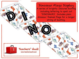
Dinosaur Flags Display: A series of brightly coloured bunting including lettering to spell out ‘DINOSAURS’. Includes plain dinosaur themed flags for a longer string of bunting. Makes a great addition to any dinosaur display or role play area.
For more Outstanding Resources for Outstanding Teachers, please visit my website www.teachersvault.co.uk
American flag bunting coloring sheet, plus three other bunting coloring sheets. The USA flag bunting is a great Flag day resource or any American celebration. For more Flag Day printables or American flag resources, check our Flag Day resources page. These Flag Day printables are great to decorate any elementary school classroom and are free to download. We also have a new AMERICAN section, full of US classroom printables covering areas like American role play areas, US Holidays and Celebrations, Classroom Organisation and Math. Plus 1000s more educational printables all FREE to download.
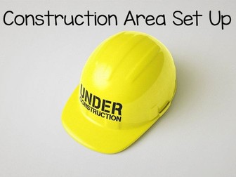
Transform your learning space into an engaging construction zone that sparks curiosity and creativity. This bunting set features vibrant ‘Construction Area’ flags flanked by two further flags adorned with playful truck designs. Also included six posters of common construction vehicles. Also, a further 7 large posters to zone the area and 8 small signs for pupils to use on and around their work. Elevate your teaching environment and inspire young minds to build, explore and construct with this eye-catching display.
Included:
Bunting with the words ‘Construction Area’
Two flags featuring truck designs
One flag with a cute hard hat design
6 construction vehicle posters
7 large construction area signs
8 small signs
You might also be interested in these construction resources:
https://www.tes.com/teaching-resource/construction-cards-human-and-physical-features-12569843
https://www.tes.com/teaching-resource/harvest-construction-cards-12713039
or these display resources:
https://www.tes.com/teaching-resource/book-corner-reading-area-display-boho-colours-12887795
https://www.tes.com/teaching-resource/growth-mindset-questions-display-12363753
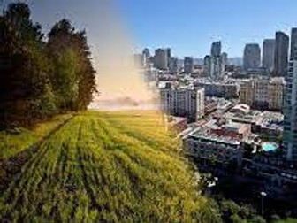
A lesson allowing students to work independently and to look at urban vs rural areas. A game of splat is included as well as re-cap opportunities for students. Guess the country flag powerpoint too!
This big savings bundle includes three more themed packs' (Easter, UK, Italy and France). Plus Y6 maths and more themed fun activities to do in class. Grab the opportunity by downloading them all for £5.
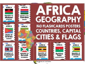
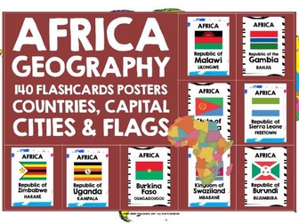
GEOGRAPHY AFRICAN COUNTRIES, CAPITAL CITIES & FLAGS FLASHCARDS POSTERS an instant and comprehensive introduction to Africa, perfect for developing locational knowledge, as well as awareness of world countries and continents
Create an instant introduction to Africa and brighten up your learning environment with this set of 54 posters / flashcards showing African countries, capital cities and flags They also give your classroom a great multicultural look and feel. They are a really useful visual prompt when you are discussing world geography in general, and Africa in particular. There may be a number of countries and capital cities that students do not know, or are not aware of, so the posters help students develop their general awareness, knowledge and understanding of Africa and its geography.
Use them as flashcards to introduce and practise the countries, capitals and flags too - it’s a traditional and successful low-tech teaching method, which gives students a welcome break from the whiteboard - varying teaching methodologies in the language learning classroom is always a good idea, and I also encourage my students to take the role of the teacher too, which they find really motivating.
The posters can be displayed horizontally across a particular learning area - alphabetically works well, though non-alphabetically is perfect for a country quest activity. There are two backgrounds to choose from - world map or black wave. I always laminate my posters / flashcards, as they are far easier to use, and they do last for years, so it's definitely worth the extra prep time and expense.
Have a browse in my store for more Geography posters / flashcards, and a wide range of other geography teaching and learning materials, with special offer bundles, resource boxes, and lots of freebies too!
The resource is non-editable file in a zipped format. It is copyright, all rights reserved. It may not be copied, rewritten, amended, shared or distributed outside your own classroom in any way. The license for purchase is a single-user license only. Please read the Terms of Use carefully.
THANK YOU AND ENJOY YOUR JOURNEY ACROSS AFRICA!
Use Our American Flag webquest of 12 informative questions to learn about Flag Day,Fourth of July and flag history. In addition to the webquest there are 7 extension activities.I always try to include a multi-curricular idea such as writing in the content area with my activities. There are also 16 fun facts about the American flag, flags of the world and the Fourth of July. After students in small groups complete the webquest activity, discuss the information learned as a class. Students can also create a short comprehension review of 5-7 questions to exchange with another group to answer. Grades 4 and up.
Use on Flag Day or any day you have an opportunity to discuss the American Flag with your students!
Help your students develop their number skills, and also provide a cross curricular link with Geography.
This National Flags Activity Pack includes
- 3 activity sheets with answers,
- National Flags 1 (Multiplication facts)
- National Flags 2 (Division facts)
- Find the flags crossword
- information sheets about 15 different countries.
The data provided in the information sheets can be used to promote discussion on concepts such as population size, population density and measurement of physical features of the landscape.
Students can also be introduced to the variety of currency used, pictures of which are readily available online.
The pack is aimed at pupils in upper KS2 and lower KS3.
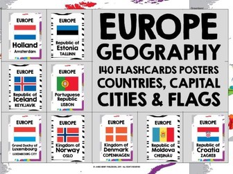
GEOGRAPHY EUROPE EUROPEAN COUNTRIES, CAPITAL CITIES AND FLAGS POSTERS / FLASHCARDS an instant and comprehensive introduction to Europe in your classroom, perfect for developing knowledge of world countries and continents 140 posters showing European countries, capital cities and flags, giving your classroom a great multicultural look and feel. They are also a great visual prompt when you are discussing world geography in general, and Europe in particular. There may be a number of countries and capital cities that students do not know, or are not aware of, so the posters help students develop their general awareness, knowledge and understanding of Europe and its geography.
I’ve included a range of islands, such as the Faroe Islands, to extend students’ knowledge of Europe a little further, and I’ve also shown some countries, for example Armenia, that are often classed as belonging either to Europe or to Asia. I’ve also included two posters for some countries, such as Greece, officially known as the Hellenic Republic - you can choose either the more frequently-used Greece or the Hellenic Republic to display. The posters look great displayed horizontally across a particular learning area - alphabetically works well, though non-alphabetically is perfect for a country quest activity! They're ideal for the annual Europe Day and European Day of Languages celebration, as well as an all year round display. There are two backgrounds to choose from - Europe map or black wave. Laminate for longevity - you'll be able to display your Europe posters for years to come!
My students find this list of Europe Countries & Capital Cities useful too - it's free to download here:
EUROPE COUNTRIES AND CAPITAL CITIES REFERENCE
https://www.tes.com/teaching-resource/geography-europe-countries-and-capital-cities-reference-12128929
The resource is non-editable in a zipped format. It is copyright, all rights reserved. It may not be copied, rewritten, shared or distributed in any way. Please read the Terms of Use carefully.
THANK YOU AND ENJOY YOUR JOURNEY ACROSS EUROPE!
GEOGRAPHY AFRICAN COUNTRIES, CAPITAL CITIES & FLAGS FLASHCARDS POSTERS an instant and comprehensive introduction to Africa, perfect for developing locational knowledge, as well as awareness of world countries and continents
Create an instant introduction to Africa and brighten up your learning environment with this set of 54 posters / flashcards showing African countries, capital cities and flags . They also give your classroom a great multicultural look and feel. They are a really useful visual prompt when you are discussing world geography in general, and Africa in particular. There may be a number of countries and capital cities that students do not know, or are not aware of, so the posters help students develop their general awareness, knowledge and understanding of Africa and its geography.
Use them as flashcards to introduce and practice the countries, capitals and flags too - it’s a traditional and successful low-tech teaching method, which gives students a welcome break from the whiteboard - varying teaching methodologies in the language learning classroom is always a good idea, and I also encourage my students to take the role of the teacher too, which they find really motivating.
The posters can be displayed horizontally across a particular learning area - alphabetically works well, though non-alphabetically is perfect for a country quest activity. There are two backgrounds to choose from - world map or black wave. I always laminate my posters / flashcards, as they are far easier to use, and they do last for years, so it’s definitely worth the extra prep time and expense.
My students find this list of Africa Countries & Capital Cities useful too - it’s free to download here:
AFRICA COUNTRIES AND CAPITAL CITIES REFERENCE LIST
https://www.tes.com/teaching-resource/geography-africa-countries-and-capital-cities-list-12446712
Have a browse in my store for more Geography posters / flashcards, and a wide range of other geography teaching and learning materials, with dollar deals, special offer bundles, and lots of freebies too!
The resource is non-editable file in a zipped format. It is copyright, all rights reserved. It may not be copied, rewritten, amended, shared or distributed outside your own classroom in any way. The license for purchase is a single-user license only. Please read the Terms of Use carefully.
THANK YOU AND ENJOY YOUR JOURNEY ACROSS AFRICA!