Hero image

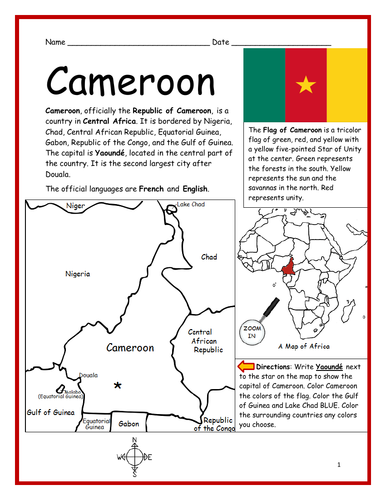
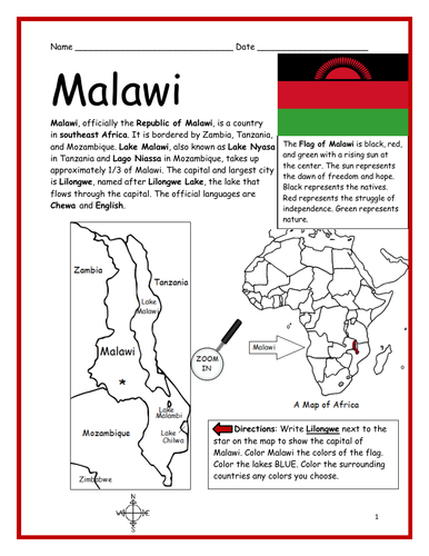
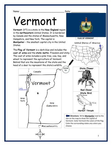
Interactive Printables

Average Rating4.56
(based on 33 reviews)

Thank you for visiting! Here you will find a selection of printable, interactive worksheets for your classroom: Basic Geography worksheets with simple maps, ESL, Spanish, Bible, Reading Comprehension and more. I hope you find the resources useful! Reviews are welcome and very much appreciated. Thank you so much.

437Uploads

346k+Views

9k+Downloads

Thank you for visiting! Here you will find a selection of printable, interactive worksheets for your classroom: Basic Geography worksheets with simple maps, ESL, Spanish, Bible, Reading Comprehension and more. I hope you find the resources useful! Reviews are welcome and very much appreciated. Thank you so much.
CHINA - Introductory Geography Worksheet
tspeelmantspeelman

CHINA - Introductory Geography Worksheet

(0)
Introduce your learners to CHINA with this printable handout of two worksheets (plus answer key). Your students will read a brief introduction to China (location, capital, language, flag), write ‘Beijing’ next to the star on the map to show the location of the capital, color the flag and map, and use the map and compass to answer 10 questions on page 2. Colored pencils and a pen or pencil are needed for this activity. No other prep needed. Basic Geography worksheet with a simple map to introduce China and practice cardinal/ordinal directions. For use with Interactive Notebooks: After your students complete the worksheets, they can cut out the map and paste into the notebook under the topic Asia/Sub-topic: China. Under the map, your students can write a summary in their own words of what they now know about China. Collect worksheets for other countries of Asia to add to the notebook! Please browse this store for a selection of printable Geography worksheets for other countries of Asia (and beyond!). Thank you so much for using my Geography worksheets in your classroom! I hope you find them useful! Reviews are welcome and very much appreciated. Notes: China shares land borders with 14 countries: Vietnam, Laos, Myanmar, India, Bhutan, Nepal, Afghanistan, Pakistan, Tajikistan, Kyrgyzstan, Kazakhstan, Russia, Mongolia, and North Korea. Pacific Ocean.
13 Colonies - United States of America
tspeelmantspeelman

13 Colonies - United States of America

(0)
Introduce your students to the 13 original colonies with this printable handout (1 worksheet plus answer key). This handout includes the list of 13 colonies and the year each was founded before declaring independence and becoming the United States in 1776. Students will write the name of each colony in the order it was founded, then write the number of each on the map. Includes Virginia, New Hampshire, New York, Massachusetts, Maryland, Connecticut, Rhode Island, Delaware, North Carolina, South Carolina, New Jersey, Pennsylvania, Georgia. Thank you so much for using my worksheets in your classroom!
GREENLAND - Introductory Geography Worksheet
tspeelmantspeelman

GREENLAND - Introductory Geography Worksheet

(0)
Introduce your learners to GREENLAND with this printable handout of two worksheets (plus answer key). Your students will read a brief introduction to Greenland (location, capital, flag, language), write ‘Nuuk’ next to the star on the map to show the location of the capital, color the small map, and use the map and compass to answer 7 multiple-choice questions on page 2. Colored pencils or crayons and a pen or pencil are needed for this activity. No other prep needed. Basic Geography worksheet with a simple map to introduce Greenland and practice cardinal and ordinal directions. For use with Interactive Notebooks: After the worksheets are completed, students can cut out the map and flag of Greenland and paste into the notebook under the topic of North America/Sub-Topic: Greenland. Under the map and flag, students can write a summary in their own words of what they now know about Greenland. Collect worksheets for other countries of North America to add to the notebook! Please browse this store for a selection of worksheets for other countries of North America (and beyond!). Thank you so much for using my Geography worksheets in your classroom! I hope you find them useful. Reviews are welcome and very much appreciated.
KAZAKHSTAN - Printable handout with simple map and flag
tspeelmantspeelman

KAZAKHSTAN - Printable handout with simple map and flag

(0)
Introduce your students to the country of KAZAKHSTAN with this printable handout of two worksheets (plus answer key). Your students will read a brief overview of Kazakhstan (location, capital, flag, language), write ‘Astana’ next to the star on the map to show the capital, trace the dotted line to show the border of Europe and Asia, color the small map, and use the map and compass to answer 8 questions. Colored pencils and a pen or pencil are needed for this activity. Basic Geography worksheet with a simple map to introduce Kazakhstan and practice cardinal and ordinal directions. Reading comprehension strategies. For use with Interactive Notebooks: After completing the handout, students can cut out the map and flag of Kazakhstan and paste into the notebook under the topic of Europe or Asia / Sub-Topic: Kazakhstan. Under the map and flag, students will write a summary in their own words of what they now know about this country. Collect handouts for other countries of Europe or Asia to add to the notebook. Please check out my store for a selection of printable handouts for countries of Europe, Asia, and beyond! Thank you so much for using my Geography worksheets in your classroom!
Sierra Leone - Introductory Geography Worksheet
tspeelmantspeelman

Sierra Leone - Introductory Geography Worksheet

(0)
Introduce your students to Sierra Leone with two worksheets (plus answer key). Your students will read a brief introduction to Sierra Leone (location, capital, flag, language), write ‘Freetown’ next to the star on the map to show the location of the capital, color the small map, and use the map and compass to answer 6 questions on page 2. Colored pencils and a pen or pencil are needed for this activity. Basic Geography worksheet with a simple map to introduce Sierra Leone and practice cardinal and ordinal directions. For use with Interactive Notebooks: After the worksheets are completed, students can cut out the map and flag and paste into the notebook under the topic of Africa/Sub-topic: Sierra Leone. Under the map and flag, your students can write a summary in their own words of what they now know about this country. Collect worksheets for other countries of Africa to add to the notebook! Please browse this store for a selection of worksheets for other countries of Africa (and beyond!) Thank you so much for using my Geography worksheets in your classroom! I hope you find them useful. Reviews are welcome and very much appreciated.
MADAGASCAR - Introductory Geography Worksheet
tspeelmantspeelman

MADAGASCAR - Introductory Geography Worksheet

(1)
Introduce your learners to MADAGASCAR in Africa with two worksheets (plus answer key). Your students will read a brief introduction to Madagascar (location, capital, flag, language), write ‘Antananarivo’ next to the star on the map to show the location of the capital, color the small map, and use the map and compass to answer 6 multiple-choice questions on page 2. Colored pencils and a pen or pencil are needed for this activity. No other prep needed. Basic Geography worksheet with a simple map to introduce the country of Madagascar and practice cardinal/ordinal directions. For use with Interactive Notebooks: After the worksheets are completed, students can cut out the map and flag and paste into the notebook under the topic of Africa / Sub-topic: Madagascar. Under the map and flag, your students can write a summary in their own words of what they now know about this country. Collect worksheets for other countries of Africa to add to the notebook! All available in this store! Thank you so much for using my Geography worksheets in your classroom! I hope you find them useful. Reviews are welcome and very much appreciated! Please browse this store for worksheets to introduce your learners to all countries of Africa and the world!
IVORY COAST - Introductory Geography Worksheet
tspeelmantspeelman

IVORY COAST - Introductory Geography Worksheet

(0)
Introduce your learners to IVORY COAST (Côte d’Ivoire) in Africa with two worksheets (plus answer key). Your students will read a brief introduction to Ivory Coast (location, capital, flag, language), write ‘Yamoussoukro’ next to the ‘P’ on the map to show the political capital of Ivory Coast, write ‘Abidjan’ next to the ‘E’ to show the economic capital, color the small map, and use the map and compass to answer 9 questions on page 2. Colored pencils and a pen or pencil are needed for this activity. No other prep needed. Basic Geography worksheet with a simple map to introduce Ivory Coast and practice cardinal and ordinal directions. For use with Interactive Notebooks: After the worksheets are completed, students can cut out the map and flag and paste into the notebook under the topic of Africa/Sub-topic: Ivory Coast. Under the map and flag, students can write a summary in their own words of what they now know about this country. Collect worksheets for other countries of Africa to add to the notebook! Please browse this store for a selection of worksheets for other countries of Africa (and beyond!). Thank you so much for using my worksheets in your classroom! Reviews are welcome and very much appreciated!
Democratic Republic of Congo - Introductory Geography Worksheet
tspeelmantspeelman

Democratic Republic of Congo - Introductory Geography Worksheet

(0)
Introduce your students to the Democratic Republic of Congo (DR Congo) with this printable handout of two worksheets (plus answer key). Your students will read a brief introduction to DR Congo (location, capital, flag, language), write ‘Kinshasa’ next to the star on the map to show the capital, trace the lines to show the location of the equator and Congo River, color the small map, and use the map and compass to answer 9 questions on page 2. Colored pencils and a pen or pencil are needed for this activity. No other prep needed. Basic Geography worksheet with a simple map to introduce DR Congo and practice cardinal and ordinal directions. For use with Interactive Notebooks: After the worksheets are completed, students can cut out the map and flag and paste into the notebook under the topic of Africa/Sub-topic: DR Congo. Under the map and flag, your students can write a summary in their own words of what they now know about this country. Collect handouts for other countries of Africa to add to the notebook! Please browse this store for a selection of printable worksheets for other countries of Africa (and beyond!). Thank you so much for using my Geography worksheets in your classroom! I hope you find them useful! Reviews are welcome and very much appreciated!
ZIMBABWE - Introductory Geography Worksheet
tspeelmantspeelman

ZIMBABWE - Introductory Geography Worksheet

(0)
Introduce your students to ZIMBABWE in Africa with this printable handout of two worksheets (plus answer key). Your students will read a brief introduction to Zimbabwe (location, capital, flag, language), write ‘Harare’ next to the star on the map to show the capital, color the small map, and use the map and compass to answer 9 questions on page 2. Colored pencils and a pen or pencil are needed for this activity. No other prep needed. Basic Geography worksheet includes a simple map to introduce the country of Zimbabwe and practice cardinal/ordinal directions. For use with Interactive Notebooks: After the worksheets are completed, students can cut out the map and flag and paste into the notebook under the topic of Africa/Sub-topic: Zimbabwe. Under the map and flag, your students can write a summary in their own words of what they now know about this country. Collect handouts for other countries of Africa to add to the notebook! Please browse this store for a selection of printable handouts for other countries of Africa (and beyond!). Thank you so much for using my Geography worksheets in your classroom! Included in resource: Lake Kariba, Zambezi River, Limpopo River, South Africa, Botswana, Zambia, Mozambique. Resource Room
SOMALIA - Introductory Geography Worksheet
tspeelmantspeelman

SOMALIA - Introductory Geography Worksheet

(0)
Introduce your students to SOMALIA in Africa with this printable handout of two worksheets (plus answer key). Your students will read a brief introduction to Somalia (location, capital, flag, language), write ‘Mogadishu’ next to the star on the map to show the capital, trace the line of the equator, color the small map, and use the map and compass to answer 9 questions on page 2. Colored pencils and a pen or pencil are needed for this activity. No other prep needed. Basic Geography worksheet includes a simple map to introduce Somalia and practice cardinal/ordinal directions. For use with Interactive Notebooks: After the worksheets are completed, students can cut out the map and flag and paste into the notebook under the topic of Africa/Sub-topic: Somalia (or Horn of Africa). Under the map and flag, your students can write a summary in their own words of what they now know about this country. Collect handouts for other countries of Africa to add to the notebook! Please browse this store for a selection of printable handouts for other countries of Africa (and beyond!). Thank you for using my Geography worksheets in your classroom! I hope you find them useful. Reviews are welcome and very much appreciated! Included on map: Horn of Africa, Ethiopia, Djibouti, Kenya, Gulf of Aden, Somali Sea, Indian Ocean, Equator
MONTHS IN SPANISH - WORD SEARCH PUZZLE
tspeelmantspeelman

MONTHS IN SPANISH - WORD SEARCH PUZZLE

(0)
Find each month in Spanish in the Word Search Puzzle. They can be found forward or backward. January - ENERO February - FEBRERO March - MARZO April - ABRIL May - MAYO June - JUNIO July - JULIO August - AGOSTO September - SEPTIEMBRE October - OCTUBRE November - NOVIEMBRE December - DICIEMBRE Thank you for using my handouts in your classroom!
SOUTHEAST REGION OF THE UNITED STATES - Printable handout
tspeelmantspeelman

SOUTHEAST REGION OF THE UNITED STATES - Printable handout

(0)
Introduce your students to the SOUTHEAST REGION of the United States with this printable handout of one page (plus answer key). Using the map of the Southeast Region, find the twelve states in the word search puzzle: Virginia, North Carolina, South Carolina, Georgia, Florida, Alabama, Arkansas, Kentucky, Louisiana, Mississippi, Tennessee, West Virginia. Handouts also available for other regions! Please check out this store for: -SOUTHWEST REGION MAP AND WORD SEARCH -NORTHEAST REGION MAP AND WORD SEARCH -MIDWEST REGION MAP AND WORD SEARCH -WEST REGION MAP AND WORD SEARCH Thank you so much for using my Geography worksheets in your classroom!
TASMANIA - Introductory Geography Worksheet
tspeelmantspeelman

TASMANIA - Introductory Geography Worksheet

(0)
Introduce your students to TASMANIA, the island state of Australia, with this printable handout of two worksheets (plus answer key). Your students will read a brief overview of Tasmania (location, capital, flag), write ‘Hobart’ next to the star on the map to show the capital, color the small map, and use the map and compass to answer 6 questions on page 2. Colored pencils and a pen or pencil are needed for this activity. Basic Geography worksheet with a simple map to introduce Tasmania and practice cardinal and ordinal directions. For use with Interactive Notebooks: After the handout is completed, students can cut out the map and flag of Tasmania and paste into the notebook under Australia/Sub-Topic: Tasmania. Under the map and flag, students can write a summary in their own words of what they now know about Tasmania. Collect handouts for other countries to add to the notebook. Please browse this store for a selection of printable Geography worksheets! Thank you so much for using my Geography worksheets in your classroom.
WESTERN REGION OF THE UNITED STATES - Printable handout
tspeelmantspeelman

WESTERN REGION OF THE UNITED STATES - Printable handout

(0)
Introduce your students to the WESTERN REGION of the United States with this printable handout of one page (plus answer key). Using the map of the West Region, find the eleven states in the word search puzzle: Alaska, California, Colorado, Hawaii, Idaho, Montana, Nevada, Oregon, Utah, Washington, Wyoming. Printable handouts for other regions also available! SOUTHWEST REGION MAP AND WORD SEARCH NORTHEAST REGION MAP AND WORD SEARCH SOUTHEAST REGION MAP AND WORD SEARCH MIDWEST REGION MAP AND WORD SEARCH Thank you so much for using my Geography worksheets in your classroom!
COLOR THE MAP OF AFRICA
tspeelmantspeelman

COLOR THE MAP OF AFRICA

(0)
Print and color the map of Africa! This printable coloring sheet of one page includes the 54 countries of Africa to color and learn. Thank you so much for using my Geography worksheets and coloring pages. Please browse this store for a selection of printable worksheets for countries of Africa and beyond!
SAMOA - Introductory Geography Worksheet
tspeelmantspeelman

SAMOA - Introductory Geography Worksheet

(0)
Introduce your learners to the country of Samoa in Oceania with two interactive worksheets (plus answer key). Your students will read a brief introduction to Samoa (location, capital, flag, language), locate and circle Samoa on the map of Oceania, write ‘Apia’ next to the star on the map of Samoa to show the location of the capital, color the small map, and use the map and compass to answer 7 multiple-choice questions on page 2. Colored pencils and a pen or pencil are needed for this activity. No other prep needed. Basic Geography worksheet with a simple map to introduce Samoa and practice cardinal and ordinal directions. For use with Interactive Notebooks: After your students complete the worksheets, they can cut out the map and flag and paste into the notebook under the topic of (example) Oceania/Sub-Topic: Samoa. Under the map and flag, students can write a summary in their own words of what they now know about Samoa. Collect worksheets for other countries of Oceania to add to the notebook! Please browse this store for a selection of worksheets for other countries of Oceania (and beyond!). Thank you so much for using my Geography worksheets in your classroom! I hope you find them useful and fun. Reviews are welcome and very much appreciated.
COLOR THE MAP OF ASIA
tspeelmantspeelman

COLOR THE MAP OF ASIA

(0)
Color and learn the map of Asia with this printable coloring page. Colored pencils or crayons are needed for this activity. No other prep needed. Countries included: Afghanistan, Armenia, Azerbaijan, Bahrain, Bangladesh, Bhutan, Brunei, Cambodia, China, Cyprus, Georgia, India, Indonesia, Iran, Iraq, Israel, Japan, Jordan, Kazakhstan, Kuwait, Kyrgyzstan, Laos, Lebanon, Malaysia, Maldives, Mongolia, Myanmar, Nepal, North Korea, Oman, Pakistan, Palestine, Philippines, Qatar, Russia, Saudi Arabia, Singapore, South Korea, Sri Lanka, Syria, Taiwan, Tajikistan, Thailand, Timor-Leste, Turkey, Turkmenistan, UAE (United Arab Emirates) , Uzbekistan, Vietnam, and Yemen. Also the Arctic Ocean, Pacific Ocean, Indian Ocean and surrounding parts of Europe and Africa. Thank you for using my Geography worksheets and coloring pages!
THE GREAT LAKES OF NORTH AMERICA Printable Worksheets
tspeelmantspeelman

THE GREAT LAKES OF NORTH AMERICA Printable Worksheets

(0)
Introduce your learners to the GREAT LAKES of North America with this printable handout of two worksheets (plus answer key). Your students will write the names of the 5 Great Lakes on the map, color the map (Great Lakes, Canada, United States) and use the map to answer 9 questions on page 2. Included on this map: Lake Superior; Lake Michigan; Lake Huron; Lake Erie; Lake Ontario; Canada Provinces Ontario and Quebec; US States: Minnesota; Wisconsin; Iowa; Illinois; Indiana; Michigan; Ohio; Pennsylvania; New York. Thank you for using my Geography worksheets! Please browse this store for a selection of printable Geography worksheets for North America and beyond.
The Emirates Word Search Puzzle
tspeelmantspeelman

The Emirates Word Search Puzzle

(0)
The United Arab Emirates consists of 7 emirates. Using the map of UAE, find the 7 emirates in this word search puzzle! 7 emirates include: Abu Dhabi, Ajman, Dubai, Fujairah, Ras al Khaimah, Sharjah, Umm al Quwain. 1 printable word search puzzle (plus answer key). Thank you so much for using my printable worksheets in your classroom! Reviews are welcome and very much appreciated. Please browse this store for more Word Search Puzzles and Geography worksheets!
MALAYSIA - Introductory Geography Worksheet
tspeelmantspeelman

MALAYSIA - Introductory Geography Worksheet

(0)
Introduce your learners to the country of Malaysia in Southeast Asia with this printable handout of two worksheets (plus answer key). Your students will read a brief overview of Malaysia (location, capital, language, flag), write ‘Kuala Lumpur’ next to the star on the map to show the location of the capital, color the small map, and use the map and compass to answer 8 questions on page 2. Colored pencils and a pen or pencil are needed for this activity. No other prep needed. Basic Geography worksheet with a simple map to introduce Malaysia. For use with Interactive Notebooks: After your students complete the worksheets, they can cut out the map and flag of Malaysia and paste into the notebook under the topic of Asia / Sub-topic: Malaysia. Under the map, students can write a summary in their own words of what they now know about this country. Collect worksheets for other countries of Asia to add to the notebook! Please browse this store for a selection of printable worksheets for other countries of Asia (and beyond!). Thank you so much for using my Geography worksheets in your classroom! Reviews are welcome and very much appreciated. Included: China Sea, Malay, Peninsular Malaysia, Borneo’s East Malaysia, Thailand, Singapore, Vietnam, Indonesia, Brunei, Philippines, Vietnam. Stripes of Glory. Jalur Gemilang.