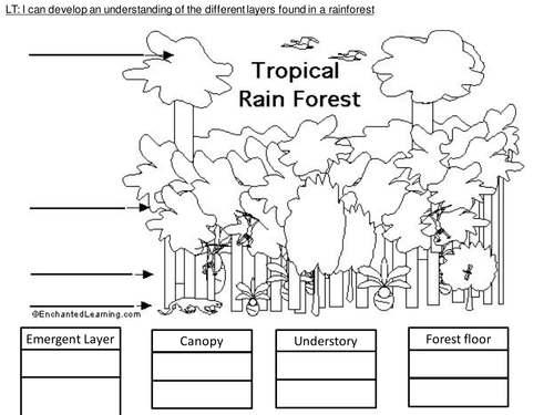
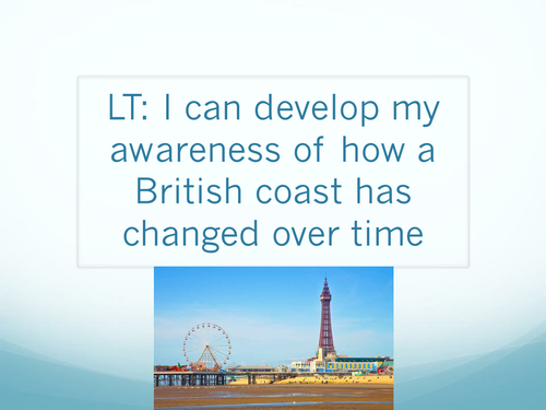
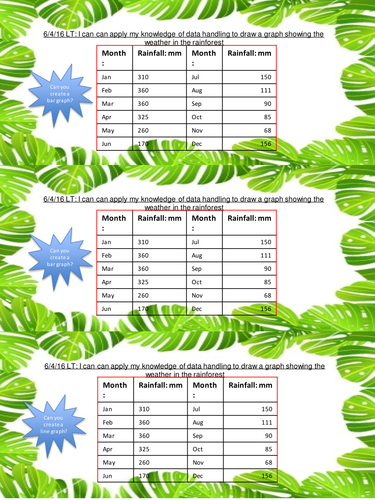
Hero image

50Uploads

53k+Views

2k+Downloads

4 way differentiated Rainforests of the world atlas/map skills activity sheets
matthewewilmotmatthewewilmot

4 way differentiated Rainforests of the world atlas/map skills activity sheets

(0)
4 world maps with the main Rainforest areas highlighted in Green for children to use their atlas skills to label as follows SEN Use the Atlas to try and find the names of the 5 countries highlighted where Tropical Rainforests are located! BA Use the Atlas to try and find the names of the 5 countries highlighted where Tropical Rainforests are located! Also can you name the 6 continents in the circles? A Use the Atlas to try and find the names of the 5 countries highlighted where Tropical Rainforests are located! Also can you name the 6 continents in the circles? In addition please label the two dotted lines. What do they represent? AA/G&T Use the Atlas to try and find the names of the 5 countries highlighted where Tropical Rainforests are located! Also can you name the 6 continents in the circles? In addition please label the two dotted lines and the solid line. What do they represent?
4 way differentiated Layers of the Rainforest worksheets
matthewewilmotmatthewewilmot

4 way differentiated Layers of the Rainforest worksheets

(0)
4 worksheets for children to demonstrate their knowledge and understanding of the names of and differences and key facts associated with the different layers of the rainforest BA a picture of the rainforest layers to colour and cut and stick information cards provided on the next page to the appropriate layer A a segmented picture of the layers of the Rainforest with space for children to record the name and some key facts about each layer AA a picture of the layers of the Rainforest in the middle of the page for children to annotate with their knowledge G&T a table with space to record information from their own research about the 4 layers and the conditions, plants and animals they might find
Bar and Line graph worksheet for amounts of Rain in the Rainforest
matthewewilmotmatthewewilmot

Bar and Line graph worksheet for amounts of Rain in the Rainforest

(0)
4 way differentiated challenge strips asking children to create either a bar or line graph from data provided about the amount of rain in the Rainforest each month Red simple bar chart about rain in the Rainforest Yellow comparative bar chart about rain in the Rainforest and in Birmingham Green line graph about rain in the Rainforest Blue comparative line graph about rain in the Rainforest and in Birmingham
Weather graphs comprehension exercise comparing the UK and France
matthewewilmotmatthewewilmot

Weather graphs comprehension exercise comparing the UK and France

(0)
A 3 way differentiated set of graphs and questions looking at comparing the weather in France and the UK For the BA they have to read and answer simple questions based on a bar chart For the A they have to read and answer slightly more challenging questions based on a comparative bar chart For the MA they have to read a line graph and answer more challenging questions
Blackpool timeline activity, 4 differentiated worksheets and a information PowerPoint
matthewewilmotmatthewewilmot

Blackpool timeline activity, 4 differentiated worksheets and a information PowerPoint

(0)
A detailed information PowerPoint about Blackpool and how it has changed and developed over time from the 1700's to modern day discussing changes in technology and the economy to fit in with the change over time of a locality strand of the Geography national curriculum Also included are 4 timeline worksheets to accompany the PowerPoint For the SEN they can cut and stick the events and order with answer sheet provided BA they have a blank timeline to write the key events on A a table to complete adding information about Transport, tourism and jobs in pre 1700's Blackpool, Victorian Blackpool and modern day Blackpool AA/G&T a similarities and differences table to complete about Blackpool in the past and Blackpool now