
44Uploads
245k+Views
135k+Downloads
All resources
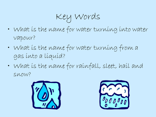
Three types of Rainfall
The objectives of the Powerpoint, animation, video and various worksheets are to identify the three different types of rainfall (frontal, convectional and relief). To investigate and understand the mechanisms behind the different types of rainfall, and to identify and explain the link between areas of high altitude and relief rainfall.
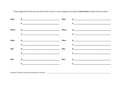
Deserts & Plant Adaptations
Pupils will be able to enquire and ask / research a series of questions, using a data capture sheet. Pupils will know what the definition of a desert is and name an example of at least one and know how desert plants are adapted to their environment.
The resources are differentiated so that higher ability pupils can ask further / higher level questions and the structure of the enquiry sheet can suggest/prompt lower ability pupils for answers. the plenery is a fun idea and it works well with year 8 pupils... surprising how much they can recall.
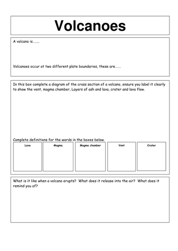
Earthquakes & Avalanches & Volcanoes
Three data capture sheets for research on Volcanoes, Avalanches and Earthquakes, useful for both KS3 and KS4; the worksheets can be used as a writing frame for video notes, Internet research or Library research.
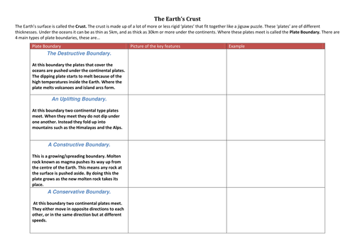
The Earth's crust (plate boundaries)
There are a number of different types of plate boundaries. For each plate boundary you will need to be able to describe (i) the movement (ii) processes which occur and (iii) an example
A differentiated set of worksheets for pupils to complete that achieves the above objective.

D-Day Assembly
A brief overview of D-Day and reflecting on the 80th Anniversary suitable for secondary aged pupils 11-18.

Eduqas Geog B Revision guide
A variety of activities to support the Eduqas Geography B Spec.
Useful for Exam preparation and revision.
Including elements of topics including: Tropical rainforests, Semi-arid environments, global atmospheric circulation, Rivers, Global Cities & Development
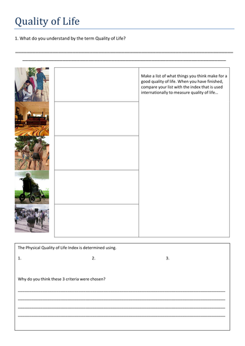
Quality of Life
Learning objectives:
To explore the idea of quality of life
To understand the ways that the international community tries to define quality of life
To compare the lifestyles of people with differing qualities of life.
Powerpoint and accompanying worksheet exploring Quality of Life, development, sustainable communities.
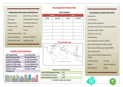
Development Word Mat
A useful word bank for KS3 Development also vocabulary / revision aid for economic and/or sustainable development.
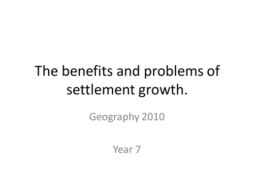
benefits and problems of settlement growth
A clear easy to follow powerpoint with activities included. some slides can be printed off individually and given to pupils as handouts.
Lesson objectives: To know how changes in the growth of settlements benefit some people more than others.
To recognise there are both good (positive) and bad (negative) points of settlement growth.
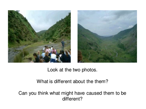
Landforms found at Plate Boundaries
AQA syllabus KS4 Tectonics Powerpoint on the landforms found at plate boundaries.
Why fold mountains and ocean trenches form at destructive plate margins.
The difference between composite volcanoes which are associated with destructive plate margins and shield volcanoes which are associated with constructive plate margins.
Glaciers Nature's Bulldozers
A worksheet and complimentary powerpoint introducing KS3 pupils to Glaciation and how Ice shapes the land.
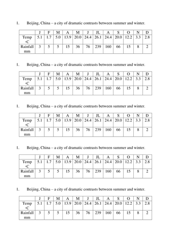
A Close up on China
A fill in the gaps worksheet activity regarding the economic development of China.
Also useful handouts: A Blank outline map of China and Climatic data for Beijing. Each are useful with Geog.3 lessons on China.
The Chilean Earthquake 2015
A PowerPoint, newspaper article, card sort and data capture sheet (Facts, Causes, Effects and Responses) on The Chilean Earthquake of 2015.
Learning Objective: to understand that Hazard resistant design and preparation procedures (& evacuation) are key factors in reducing the effects i.e deaths of high magnitude earthquakes.
Students work towards answering the question: why did only 13 people die in an 8.7 magnitude earthquake? Higher level students can read the newspaper article and classify the statements in to facts, causes, effects, responses, or you could use the card sort.

Characteristics of the CBD
A 'Fill in the Blanks' worksheet that revises the characteristics of the Central Business District.
Useful for Land Use Zones, Urban Structure, Settlements.

Investigating Coasts
A planning matrix of 10 lessons investigating the coastal environment, specifically designed for SEN pupils in KS3.
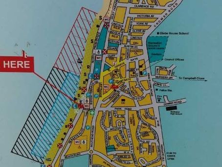
Hunstanton Clone Town Survey (Virtual Fieldwork)
Geographical Investigation: Does Hunstanton need its own identity?
A clone town survey identifies the number of independent shops that are remaining in the UK’s high streets, compared to chain stores.
Use Google Street View and the sheets to calculate the clone town score for Hunstanton. Is Hunstanton a clone town?
Is Hunstanton a good example of a sustainable community?
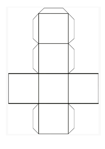
Plate tectonics cube display (4 types of plate margin)
A Geography display that shows the different types of plate boundaries/margins. (destructive, constructive, collision and conservative)
The aim is for pupils to draw 4 labelled diagrams on the blank template of the four types of plate margins.
Pupils then cut out the cube template, fold and stick together and they can then be hung up as a display using string.... The more colourful the better! They are also good for revision aids!
*Please be sure to instruct your pupils to draw their diagrams the correct way round so the diagrams can be read when the cube is glued together!
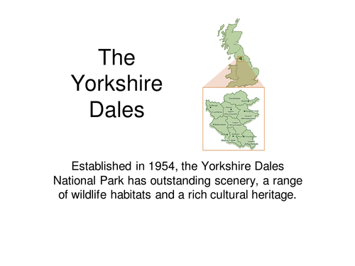
Yorkshire Dales
A useful revision aid to the Yorkshire Dales Limestone (Karst) landscape, features found in the Yorkshire Dales National Park
OCR Geography B (Enquiring Minds) Topic 1 Global Hazards 1.1 Weather
OCR Geography B (Enquiring Minds) Topic 1 Global Hazards 1.1 How can weather be hazardous?
47 slide PowerPoint activities, films and resources covering:
The Global Circulation system
Climatic zones
Extremes of weather in contrasting countries
Distribution and frequency of tropical storms
El Nino ans La Nina
Drought and desertification case study
Use of GIS and Geographical Skills