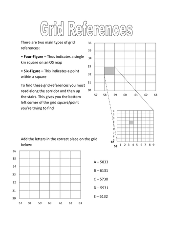
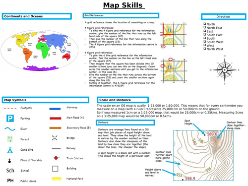
Map skills in geography

Lessons and activities for secondary geography students studying map skills including grid referencing and coordinates, contour lines and compass skills.

Tes Resources Team

Map on a table with a notebook, pen and camera, improving map skills

Support young geographers in learning how to use and interpret maps

Map reading is an important skill for geographers both in the classroom and when participating in schemes such as the Duke of Edinburgh's Award. Secondary students are required to learn the necessary skills to interpret Ordnance Survey maps, use grid references, compasses, contour and scale in addition to topographical and other thematic mapping.

With this in mind, we have gathered together a collection of lessons, worksheets, booklets and activities to support you in teaching map skills to secondary geography students for both classroom and field learning. 

Geography Skills     Map Skills & Symbols
Miss R

Geography Skills Map Skills & Symbols

(19)
Geography Skills Map Skills & Symbols This is a full lesson PP that is part of a humanities curriculum covering History and Geography strands. This lesson is ready to teach and can be used as part of the whole unit that I have uploaded, but each is a standalone lesson so can be taught alone...
Map Skills Worksheet 1
Joshua Liversidge

Map Skills Worksheet 1

(0)
Up to date worksheet for map skills for any Geography curriculum and Key Stage. Includes: 4fig grid references 6fig grid references direction compass scale map symbols and more
Map Symbols Quiz
imarshall1

Map Symbols Quiz

(7)
Here's a Jeopardy style quiz that I put together a while back for students undertaking the Duke of Edinburgh Award. It was designed to conclude a series of navigation and map reading sessions. Ideal revision for symbols used on Ordnance Survey 1:25,000 Maps.
Geography Mapping Skills Work Booklet
Teach Trends

Geography Mapping Skills Work Booklet

(0)
This work booklet guides pupils through vital mapping skills by giving them a 'how to guide' as well as a chance to practise their new skills in a variety of questions and tasks. The booklet is aimed at children in upper KS2 and lower KS3 and can be easily adapted to suit. The booklet can be given a...
Battleships (4 and 6-figure) Grid-Reference Activity
Matt Sherwen

Battleships (4 and 6-figure) Grid-Reference Activity

(0)
Through the classic game of Battleships, this activity will help reinforce the concept of (coordinates), specifically 4 and 6 digit grid-references in a fun way. There are two pages to this download. The first contains a 4-digit grid-reference game and a separate 6-digit game. The second page is th...
6 Figure grid references worksheet
Gnoland

6 Figure grid references worksheet

(1)
This worksheet combines 6 figure grid references with geographical knowledge of Europe. Students will be both following 6 figure grid references and finding them out. This worksheet has been used with years 7-10. Students will need a map of Europe displayed on the board (or most students have a map...
River features on a map activity
BristolAvonRiversTrust

River features on a map activity

(0)
Explore river features on a map. Use map skills and river knowledge to complete this activity. This activity comes with a map of the River Chew. There are things to find and calculations to be done. Find more river related education resources on the [Bristol Avon Rivers Trust website](https://bris...